Stockholm - Stockholm Arlanda
Airport details
| Country | Sweden |
| State | Stockholms län |
| Region | ES |
| Airspace | Sweden Ctr |
| Municipality | Sigtuna kommun |
| Elevation | 137ft (42m) |
| Timezone | GMT +1 |
| Coordinates | 59.65194, 17.91861 |
| Magnetic var | |
| Type | land |
| Available since | X-Plane v10.40 |
| ICAO code | ESSA |
| IATA code | ARN |
| FAA code | n/a |
Communication
| Stockholm Arlanda ATIS | 121.625 |
| Stockholm Arlanda Clearance DEL | 121.825 |
| Stockholm Arlanda Ground Control S | 121.975 |
| Stockholm Arlanda Ground Control N | 121.925 |
| Stockholm Arlanda Ground Control W | 121.700 |
| Stockholm Arlanda Tower | 118.500 |
| Stockholm Arlanda STOCKHOLM CON | 123.750 |
| Stockholm Arlanda Approach 123.750 | 123.750 |
| Stockholm Arlanda Approach 126.650 | 123.650 |
| Stockholm Arlanda Departure 126.650 | 126.650 |
| Stockholm Arlanda Departure 123.750 | 123.750 |
Approach frequencies
| LOC | RW08 | 109.55 | 18.00mi |
| ILS-cat-III | RW01L | 109.9 | 18.00mi |
| ILS-cat-III | RW01R | 109.35 | 18.00mi |
| ILS-cat-III | RW19L | 111.35 | 18.00mi |
| ILS-cat-I | RW19R | 110.7 | 18.00mi |
| ILS-cat-I | RW26 | 110.1 | 18.00mi |
| 3° GS | RW01L | 109.9 | 18.00mi |
| 3° GS | RW26 | 110.1 | 18.00mi |
| 3° GS | RW19L | 111.35 | 18.00mi |
| 3° GS | RW19R | 110.7 | 18.00mi |
| 3° GS | RW01R | 109.35 | 18.00mi |
Nearby Points of Interest:
Husby gamla kyrkskola
-Husby-Ärlinghundra socken
-U Fv1992;157
-Odensala kyrka
-Odensala socken
-Uppland Runic Inscription 442
-Uppland Runic Inscription 448
-Uppland Runic Inscription 453
-Valsta kyrka
-Uppland Runic Inscription 324
-Uppland Runic Inscription 378
-Uppland Runic Inscription 413
-Norrsunda socken
-Uppland Runic Inscription 356
-Lunda socken
-Uppland Runic Inscription 377
-Uppland Runic Inscription 308
-Uppland Runic Inscription 323
-Skånela socken
-Upplands runinskrifter 375
-Vidbo socken
-Uppland Runic Inscription 376
-Uppland Runic Inscription 439
-Uppland Runic Inscription 325
-Markims socken
Runway info
Runway 01L / 19R  | ||
| length | 3296m (10814ft) | |
| bearing | 20° / 200° | |
| width | 45m (148ft) | |
| surface | concrete | |
| Runway 08 / 26 | ||
| length | 2493m (8179ft) | |
| bearing | 83° / 263° | |
| width | 45m (148ft) | |
| surface | concrete | |
| Runway 01R / 19L | ||
| length | 2496m (8189ft) | |
| bearing | 20° / 200° | |
| width | 45m (148ft) | |
| surface | asphalt | |
| blast zone | 59m (194ft) / 0m (0ft) | |
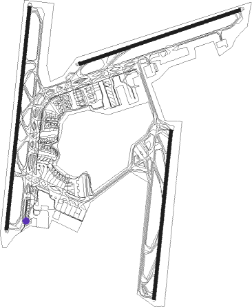
Airport layout - parking location S79
Taxiway locations
|
Parking locations
|
Nearby beacons
| code | identifier | dist | bearing | frequency |
|---|---|---|---|---|
| ARL | ARLANDA (STOCKHOLM) VOR/DME | 0.1 | 290° | 116 |
| WA | ARLANDA (STOCKHOLM) NDB | 0.2 | 320° | 348 |
| ASE | (STOCKHOLM) DME | 1.4 | 111° | 114.45 |
| ANW | (STOCKHOLM) DME | 4.1 | 313° | 112.05 |
| ASW | (STOCKHOLM) DME | 4.8 | 237° | 113.75 |
| ANE | (STOCKHOLM) DME | 4.9 | 73° | 113.30 |
| TEB | TEBBY VOR/DME | 11.2 | 113° | 117.10 |
| LNA | LENA NDB | 18.3 | 259° | 330 |
| ERK | ERKEN NDB | 19.3 | 60° | 383 |
| UP | UPPSALA NDB | 20.7 | 326° | 366 |
| COR | CORNER NDB | 26.9 | 228° | 388 |
| HMR | HAMMAR VOR/DME | 40.2 | 37° | 112.60 |
| TRS | TROSA VOR/DME | 44.7 | 210° | 114.30 |
| PEO | SKAVSTA (STOCKHOLM) NDB | 57.9 | 226° | 398 |
Departure and arrival routes
| Transition altitude | 5000ft |
| SID end points | distance | outbound heading | |
|---|---|---|---|
| RW01L | |||
| RESN4C | 43mi | 8° | |
| TOVR5C | 26mi | 83° | |
| MENG2C, BABA4C | 28mi | 106° | |
| TRS5C | 45mi | 210° | |
| NOSL5C | 40mi | 229° | |
| PETE1C | 38mi | 244° | |
| KOGA4C | 33mi | 302° | |
| RW01R | |||
| RESN3B | 43mi | 8° | |
| TOVR4B | 26mi | 83° | |
| BABA3B | 28mi | 106° | |
| TRS4B | 45mi | 210° | |
| NOSL4B | 40mi | 229° | |
| PETE1B | 38mi | 244° | |
| KOGA3B | 33mi | 302° | |
| RW08 | |||
| RESN3L, LUMA5R | 43mi | 8° | |
| TOVR4L, TOVR4R | 26mi | 83° | |
| BABA3R, BABA3L | 28mi | 106° | |
| TRS5L, GALN3R | 45mi | 210° | |
| DIGL3R, NOSL5L | 40mi | 229° | |
| PETE1L, ABEN3R | 38mi | 244° | |
| TALE5R, KOGA3L | 33mi | 302° | |
| RW19L | |||
| LUMA5Q | 43mi | 8° | |
| TOVR4E | 26mi | 83° | |
| BABA3E | 28mi | 106° | |
| TRS5E, GALN5Q | 45mi | 210° | |
| NOSL5E, DIGL5Q | 40mi | 229° | |
| PETE1E, ABEN5Q | 38mi | 244° | |
| TALE5Q | 33mi | 302° | |
| RW19R | |||
| RESN5G | 43mi | 8° | |
| TOVR5G | 26mi | 83° | |
| BABA4G | 28mi | 106° | |
| TRS5G | 45mi | 210° | |
| NOSL5G | 40mi | 229° | |
| PETE1G | 38mi | 244° | |
| KOGA5G | 33mi | 302° | |
| RW26 | |||
| RESN3K | 43mi | 8° | |
| TOVR4K | 26mi | 83° | |
| BABA3K | 28mi | 106° | |
| TRS3K | 45mi | 210° | |
| NOSL3K | 40mi | 229° | |
| PETE1K | 38mi | 244° | |
| KOGA3K | 33mi | 302° | |
| STAR starting points | distance | inbound heading | |
|---|---|---|---|
| RW01 (ALL) | |||
| NILU2M | 50.2 | 2° | |
| ELTO7M | 29.9 | 101° | |
| HMR5M | 40.2 | 217° | |
| XILA4M | 35.1 | 270° | |
| RW01L | |||
| NILU2J | 50.2 | 2° | |
| ELTO3J | 29.9 | 101° | |
| HMR3J | 40.2 | 217° | |
| XILA3J | 35.1 | 270° | |
| RW08 | |||
| NILU2S | 50.2 | 2° | |
| ELTO7S | 29.9 | 101° | |
| HMR5S | 40.2 | 217° | |
| XILA4S | 35.1 | 270° | |
| RW19 (ALL) | |||
| NILU2P | 50.2 | 2° | |
| ELTO7P | 29.9 | 101° | |
| HMR4P | 40.2 | 217° | |
| XILA5P | 35.1 | 270° | |
| RW19R | |||
| NILU2N | 50.2 | 2° | |
| ELTO3N | 29.9 | 101° | |
| HMR3N | 40.2 | 217° | |
| XILA3N | 35.1 | 270° | |
| RW26 | |||
| NILU2T, NILU2V | 50.2 | 2° | |
| ELTO2H, ELTO4T, ELTO3V | 29.9 | 101° | |
| HMR3V, HMR4T | 40.2 | 217° | |
| XILA3V, XILA5T | 35.1 | 270° | |
Instrument approach procedures
| runway | airway (heading) | route (dist, bearing) |
|---|---|---|
| RW01LY | ALJAC (76°) | ALJAC 4000ft SA731 (5mi, 96°) 4000ft |
| RNAV | SA731 4000ft SA732 (3mi, 96°) 3500ft SA733 (5mi, 71°) ESSA (5mi, 20°) 155ft SA515 (turn) (3680mi, 197°) 1500ft | |
| RW01RX | INLUX (66°) | INLUX 4000ft SA745 (4mi, 95°) 3500ft |
| RNAV | SA745 3500ft SA740 (4mi, 79°) 2500ft SA739 (3mi, 60°) SA638 (2mi, 43°) ESSA (4mi, 344°) 189ft ESSA (turn) (3679mi, 197°) 600ft (turn) 1500ft | |
| RW01RY | OGMAK (344°) | OGMAK 4000ft SA649 (4mi, 350°) SA648 (4mi, 350°) 2500ft |
| RNAV | SA648 2500ft SA647 (3mi, 330°) SA638 (2mi, 344°) ESSA (4mi, 344°) 189ft ESSA (turn) (3679mi, 197°) 600ft (turn) 1500ft | |
| RW01RZ | REYMY (278°) | REYMY 4000ft SA575 (6mi, 259°) 2500ft |
| RNAV | SA575 2500ft SA571 (2mi, 259°) 2300ft SA638 (4mi, 293°) ESSA (4mi, 344°) 189ft ESSA (turn) (3679mi, 197°) 600ft (turn) 1500ft | |
| RW19RX | BALVI (106°) | BALVI 5000ft SA872 (4mi, 76°) SA873 (3mi, 82°) 3500ft |
| RNAV | SA873 3500ft SA543 (6mi, 115°) ESSA (4mi, 200°) 169ft (3679mi, 197°) 1500ft (turn) 1500ft | |
| RW19RY | ELFEC (175°) | ELFEC 5000ft SA874 (4mi, 202°) SA875 (3mi, 148°) 3500ft |
| RNAV | SA875 3500ft SA542 (5mi, 149°) SA543 (2mi, 173°) ESSA (4mi, 200°) 169ft (3679mi, 197°) 1500ft (turn) 1500ft | |
| RW26-Y | SA501 (186°) | SA501 5000ft SA502 (6mi, 93°) SA503 (3mi, 133°) 3400ft |
| RNAV | SA503 3400ft SA504 (5mi, 221°) ESSA (7mi, 262°) 178ft SA730 (4mi, 265°) SA730 (turn) 1500ft |
Holding patterns
| STAR name | hold at | type | turn | heading* | altitude | leg | speed limit |
|---|---|---|---|---|---|---|---|
| ELTO4T | ELTOK | VHF | left | 285 (105)° | > 10000ft | 1.5min timed | 230 |
| ELTO4T | ERK | FIX | left | 38 (218)° | > 2500ft | 1.0min timed | 230 |
| ELTO7M | ELTOK | VHF | left | 285 (105)° | > 10000ft | 1.5min timed | 230 |
| ELTO7M | LNA | FIX | left | 259 (79)° | > 2500ft | 1.0min timed | 230 |
| ELTO7P | BALVI | VHF | left | 294 (114)° | > 2500ft | 1.0min timed | 230 |
| ELTO7P | ELTOK | VHF | left | 285 (105)° | > 10000ft | 1.5min timed | 230 |
| ELTO7S | BALVI | VHF | left | 294 (114)° | > 2500ft | 1.0min timed | 230 |
| ELTO7S | ELTOK | VHF | left | 285 (105)° | > 10000ft | 1.5min timed | 230 |
| HMR4P | ERK | FIX | left | 38 (218)° | > 2500ft | 1.0min timed | 230 |
| HMR4P | HMR | NDB | left | 11 (191)° | > 10000ft | 1.5min timed | 230 |
| HMR4T | ERK | FIX | left | 38 (218)° | > 2500ft | 1.0min timed | 230 |
| HMR4T | HMR | NDB | left | 11 (191)° | > 10000ft | 1.5min timed | 230 |
| HMR5M | HMR | NDB | left | 11 (191)° | > 10000ft | 1.5min timed | 230 |
| HMR5M | TEB | NDB | right | 177 (357)° | > 2500ft | 1.0min timed | 230 |
| HMR5S | HMR | NDB | left | 11 (191)° | > 10000ft | 1.5min timed | 230 |
| HMR5S | TEB | NDB | right | 177 (357)° | > 2500ft | 1.0min timed | 230 |
| NILU2M | NILUG | VHF | right | 187 (7)° | > 10000ft | 1.0min timed | 230 |
| NILU2M | TEB | NDB | right | 177 (357)° | > 2500ft | 1.0min timed | 230 |
| NILU2P | ERK | FIX | left | 38 (218)° | > 2500ft | 1.0min timed | 230 |
| NILU2P | NILUG | VHF | right | 187 (7)° | > 10000ft | 1.0min timed | 230 |
| NILU2P | TEB | NDB | right | 177 (357)° | > 2500ft | 1.0min timed | 230 |
| NILU2S | NILUG | VHF | right | 187 (7)° | > 10000ft | 1.0min timed | 230 |
| NILU2S | TEB | NDB | right | 177 (357)° | > 2500ft | 1.0min timed | 230 |
| NILU2T | NILUG | VHF | right | 187 (7)° | > 10000ft | 1.0min timed | 230 |
| NILU2T | TEB | NDB | right | 177 (357)° | > 2500ft | 1.0min timed | 230 |
| XILA4M | TEB | NDB | right | 177 (357)° | > 2500ft | 1.0min timed | 230 |
| XILA4M | XILAN | VHF | left | 68 (248)° | 10000ft - 24500ft | 1.5min timed | 230 |
| XILA4S | TEB | NDB | right | 177 (357)° | > 2500ft | 1.0min timed | 230 |
| XILA4S | XILAN | VHF | left | 68 (248)° | 10000ft - 24500ft | 1.5min timed | 230 |
| XILA5P | ERK | FIX | left | 38 (218)° | > 2500ft | 1.0min timed | 230 |
| XILA5P | XILAN | VHF | left | 68 (248)° | 10000ft - 24500ft | 1.5min timed | 230 |
| XILA5T | TEB | NDB | right | 177 (357)° | > 2500ft | 1.0min timed | 230 |
| XILA5T | XILAN | VHF | left | 68 (248)° | 10000ft - 24500ft | 1.5min timed | 230 |
| *) magnetic outbound (inbound) holding course | |||||||
Disclaimer
The information on this website is not for real aviation. Use this data with the X-Plane flight simulator only! Data taken with kind consent from X-Plane 12 source code and data files. Content is subject to change without notice.