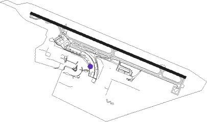
Port Louis - Sir Seewoosagur Ramgoolam Intl
Airport details
| Country | Mauritius |
| State | Grand Port |
| Region | FI |
| Airspace | Mauritius Ctr |
| Elevation | 186ft (57m) |
| Timezone | GMT +4 |
| Coordinates | -20.42967, 57.67484 |
| Magnetic var | |
| Type | land |
| Available since | X-Plane v10.40 |
| ICAO code | FIMP |
| IATA code | MRU |
| FAA code | n/a |
Communication
| Sir Seewoosagur Ramgoolam Intl ATIS | 126.200 |
| Sir Seewoosagur Ramgoolam Intl Tower | 118.100 |
| Sir Seewoosagur Ramgoolam Intl Approach | 119.100 |
Approach frequencies
| ILS-cat-I | RW14 | 109.9 | 18.00mi |
| 3.5° GS | RW14 | 109.9 | 18.00mi |
Runway info
| Runway 14 / 32 | ||
| length | 3373m (11066ft) | |
| bearing | 116° / 296° | |
| width | 45m (148ft) | |
| surface | asphalt | |
| displ threshold | 329m (1079ft) / 0m (0ft) | |
| blast zone | 61m (200ft) / 60m (197ft) | |
Nearby beacons
| code | identifier | dist | bearing | frequency |
|---|---|---|---|---|
| PLS | PLAISANCE (MAURITIUS) VOR/DME | 0.9 | 308° | 113.70 |
| MS | PLAISANCE (MAURITIUS) NDB | 1 | 124° | 343 |
| FF | FLIC EN FLAC (MAURITIUS) NDB | 19.2 | 296° | 258 |
| GBY | GRAND BAY VOR/DME | 25.2 | 350° | 114.80 |
Departure and arrival routes
| Transition altitude | 4000ft |
| SID end points | distance | outbound heading | |
|---|---|---|---|
| RW14 | |||
| UDMED1 | 150mi | 22° | |
| ETGOR1 | 45mi | 230° | |
| IBSIS1 | 80mi | 245° | |
| SOBAT1 | 81mi | 258° | |
| RASMA1 | 93mi | 278° | |
| NIBIS1 | 147mi | 303° | |
| TIBAG1 | 167mi | 313° | |
| OKMAR1 | 162mi | 324° | |
| GABKI1 | 25mi | 350° | |
| UTIVA1 | 151mi | 352° | |
| RW32 | |||
| UDME1B | 150mi | 22° | |
| TAPE1B | 150mi | 42° | |
| DUDI1B | 150mi | 51° | |
| GUTK1B | 150mi | 59° | |
| ARIG1B | 150mi | 65° | |
| OVTI1B | 150mi | 70° | |
| IXAB1B | 150mi | 84° | |
| KINI1B | 149mi | 102° | |
| ATLO1B | 149mi | 113° | |
| ETGO1B | 45mi | 230° | |
| IBSI1B | 80mi | 245° | |
| SOBA1B | 81mi | 258° | |
| RASM1B | 93mi | 278° | |
| GERU1B | 13mi | 297° | |
| NIBI1B | 147mi | 303° | |
| TIBA1B | 167mi | 313° | |
| OKMA1B | 221mi | 325° | |
| UTIV1B | 151mi | 352° | |
| STAR starting points | distance | inbound heading | |
|---|---|---|---|
| RW14 | |||
| FF1 | 19.2 | 116° | |
| GABKI1 | 25.2 | 170° | |
| RW32 | |||
| EPREX1 | 14.3 | 265° | |
| GEVEV1 | 14.1 | 295° | |
| EVOTU1 | 14.1 | 327° | |
Instrument approach procedures
| runway | airway (heading) | route (dist, bearing) |
|---|---|---|
| RW14 | FF (116°) | FF 4000ft GERUS (7mi, 115°) CR14 (2mi, 115°) 3940ft |
| RW14 | GABKI (170°) | GABKI 4000ft ESPIR (15mi, 222°) 4000ft GERUS (8mi, 160°) CR14 (2mi, 115°) 3940ft |
| RNAV | CR14 3940ft ETLIV (turn) 3570ft FIMP (9mi, 117°) 233ft EPNES (3mi, 112°) (3602mi, 290°) 4000ft | |
| RW32 | EPREX (265°) | EPREX 4000ft ESTEK (8mi, 208°) 3590ft |
| RW32 | EVOTU (327°) | EVOTU 4000ft ESTEK (8mi, 29°) 3590ft |
| RW32 | GEVEV (295°) | GEVEV 4000ft ESTEK (2mi, 296°) 3590ft |
| RNAV | ESTEK 3590ft EPNUK (6mi, 296°) 1740ft FIMP (6mi, 294°) 148ft (3599mi, 290°) 590ft IBKOV (3599mi, 110°) IBKOV (turn) 4000ft |
Holding patterns
| STAR name | hold at | type | turn | heading* | altitude | leg | speed limit |
|---|---|---|---|---|---|---|---|
| EPREX1 | GABKI | VHF | left | 59 (239)° | > 4000ft | 1.0min timed | ICAO rules |
| EPREX1 | GEVEV | VHF | right | 136 (316)° | > 4000ft | 1.0min timed | ICAO rules |
| EVOTU1 | GEVEV | VHF | right | 136 (316)° | > 4000ft | 1.0min timed | ICAO rules |
| FF1 | FF | FIX | left | 316 (136)° | > 4000ft | 1.0min timed | ICAO rules |
| GABKI1 | GABKI | VHF | left | 59 (239)° | > 4000ft | 1.0min timed | ICAO rules |
| GEVEV1 | GEVEV | VHF | right | 136 (316)° | > 4000ft | 1.0min timed | ICAO rules |
| *) magnetic outbound (inbound) holding course | |||||||
Disclaimer
The information on this website is not for real aviation. Use this data with the X-Plane flight simulator only! Data taken with kind consent from X-Plane 12 source code and data files. Content is subject to change without notice.
