Kenosha - Kenosha Regl
Airport details
| Country | United States of America |
| State | Wisconsin |
| Region | K5 |
| Airspace | Chicago Ctr |
| Municipality | Kenosha |
| Elevation | 743ft (226m) |
| Timezone | GMT -6 |
| Coordinates | 42.59570, -87.92780 |
| Magnetic var | |
| Type | land |
| Available since | X-Plane v10.40 |
| ICAO code | KENW |
| IATA code | ENW |
| FAA code | ENW |
Communication
| Kenosha Regl ATIS | 127.175 |
| Kenosha Regl CTAF | 118.600 |
| Kenosha Regl UNICOM | 122.950 |
| Kenosha Regl Ground Control | 121.875 |
| Kenosha Regl Tower | 118.600 |
| Kenosha Regl MILWAUKEE Approach/Departure | 135.875 |
Approach frequencies
| ILS-cat-I | RW07L | 109.35 | 18.00mi |
| 3° GS | RW07L | 109.35 | 18.00mi |
Nearby Points of Interest:
Washington Park Clubhouse
-Kenosha County Courthouse and Jail
-Civic Center Historic District
-Bradford Community Church
-Gilbert M. Simmons Memorial Library
-St. Matthew's Episcopal Church
-Library Park Historic District
-Anthony and Caroline Isermann House
-Frank and Jane Isermann House
-Simmons Island Beach House
-Manor House
-Third Avenue Historic District
-Kemper Hall
-Southport Beach House
-Chiwaukee Prairie
-Henry I. Paddock House
-George Murray House
-Racine College
-Uptown Theater
-Camp Logan
-Johnson Wax Headquarters
-Thomas P. Hardy House
-George Bray Neighborhood Center
-Chauncey Hall House
-Mitchell Lewis Building
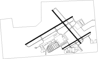
Runway info
Runway 7L / 25R  | ||
| length | 1674m (5492ft) | |
| bearing | 70° / 250° | |
| width | 30m (100ft) | |
| surface | concrete | |
| Runway 15 / 33 | ||
| length | 1346m (4416ft) | |
| bearing | 135° / 315° | |
| width | 30m (100ft) | |
| surface | concrete | |
| Runway 7R / 25L | ||
| length | 1005m (3297ft) | |
| bearing | 70° / 250° | |
| width | 23m (75ft) | |
| surface | asphalt | |
Nearby beacons
| code | identifier | dist | bearing | frequency |
|---|---|---|---|---|
| ENW | DME | 0.2 | 311° | 109.20 |
| RA | PASER (RACINE) NDB | 5.3 | 18° | 206 |
| UG | WAUKE (CHICAGO/WAUKEGAN) NDB | 9.6 | 136° | 379 |
| HRK | (RACINE) DME | 11.1 | 34° | 117.70 |
| BUU | (BURLINGTON) DME | 17.4 | 284° | 114.50 |
| OBK | NORTHBROOK VOR/DME | 22.5 | 184° | 113 |
| LJT | (MILWAUKEE) DME | 31.2 | 348° | 115.65 |
| BAE | BADGER (MILWAUKEE) VOR/DME | 35 | 326° | 116.40 |
| GCO | DME | 36.1 | 178° | 108.25 |
| DPA | DUPAGE (CHICAGO) VOR/DME | 46.3 | 211° | 108.40 |
| RYV | ROCK RIVER (WATERTOWN) NDB | 49.3 | 306° | 371 |
| BJB | WEST BEND VOR | 50.3 | 347° | 109.80 |
| MX | KEDZI (CHICAGO) NDB | 52.3 | 164° | 248 |
| UNU | JUNEAU NDB | 60.5 | 317° | 344 |
Departure and arrival routes
| Transition altitude | 18000ft |
| Transition level | 18000ft |
| SID end points | distance | outbound heading | |
|---|---|---|---|
| ALL | |||
| UECKR6 | 42mi | 143° | |
| ACCRA5 | 40mi | 188° | |
| STAR starting points | distance | inbound heading | |
|---|---|---|---|
| ALL | |||
| GOPAC2 | 25.3 | 114° | |
Instrument approach procedures
| runway | airway (heading) | route (dist, bearing) |
|---|---|---|
| RW07L | DIKHU (70°) | DIKHU 3000ft |
| RW07L | FARMM (59°) | FARMM DIKHU (14mi, 48°) 3000ft |
| RW07L | OBK (4°) | OBK FARIV (13mi, 323°) 3000ft DIKHU (7mi, 326°) 3000ft |
| RW07L | VEENA (106°) | VEENA DIKHU (13mi, 144°) 3000ft |
| RNAV | DIKHU 3000ft AHYOB (6mi, 70°) 2400ft TABTE (4mi, 70°) 1280ft KENW (2mi, 73°) 798ft (5314mi, 116°) 2500ft DIKHU (5324mi, 296°) 3000ft DIKHU (turn) | |
| RW15 | PETTY (232°) | PETTY KILME (16mi, 266°) 3000ft IPIGY (5mi, 242°) 3000ft |
| RW15 | VEENA (106°) | VEENA IPIGY (10mi, 78°) 3000ft |
| RNAV | IPIGY 3000ft KENUF (6mi, 135°) 2400ft KENW (5mi, 136°) 766ft (5314mi, 116°) 1142ft VEENA (5330mi, 296°) 3000ft VEENA (turn) | |
| RW25R | PETTY (232°) | PETTY GAVSE (9mi, 204°) 3000ft |
| RW25R | TALOR (271°) | TALOR GAVSE (6mi, 320°) 3000ft |
| RNAV | GAVSE 3000ft BOCIJ (6mi, 250°) 2400ft TALGE (4mi, 250°) 1220ft KENW (2mi, 247°) 752ft (5314mi, 116°) 923ft AHYOB (5319mi, 296°) VEENA (15mi, 300°) 3000ft VEENA (turn) | |
| RW33 | PAPPI (315°) | PAPPI INSAW (13mi, 316°) 3000ft |
| RW33 | TALOR (271°) | TALOR KODOW (7mi, 210°) 3000ft INSAW (5mi, 242°) 3000ft |
| RW33 | WARPI (338°) | WARPI INSAW (12mi, 4°) 3000ft |
| RNAV | INSAW 3000ft KOKNE (6mi, 315°) 2400ft APPLR (3mi, 315°) 1440ft KENW (3mi, 313°) 758ft (5314mi, 116°) 1160ft KENUF (5317mi, 296°) VEENA (14mi, 276°) 3000ft VEENA (turn) |
Holding patterns
| STAR name | hold at | type | turn | heading* | altitude | leg | speed limit |
|---|---|---|---|---|---|---|---|
| GOPAC2 | LEEDN | VHF | right | 181 (1)° | DME 10.0mi | ICAO rules | |
| GOPAC2 | ZOWRO | VHF | right | 273 (93)° | DME 10.0mi | ICAO rules | |
| *) magnetic outbound (inbound) holding course | |||||||
Disclaimer
The information on this website is not for real aviation. Use this data with the X-Plane flight simulator only! Data taken with kind consent from X-Plane 12 source code and data files. Content is subject to change without notice.