Lawrence - Lawrence Muni
Airport details
| Country | United States of America |
| State | Massachusetts |
| Region | K6 |
| Airspace | Boston Ctr |
| Municipality | North Andover |
| Elevation | 145ft (44m) |
| Timezone | GMT -5 |
| Coordinates | 42.71719, -71.12341 |
| Magnetic var | |
| Type | land |
| Available since | X-Plane v10.40 |
| ICAO code | KLWM |
| IATA code | LWM |
| FAA code | LWM |
Communication
| Lawrence Muni ATIS | 126.750 |
| Lawrence Muni Ground Control | 124.300 |
| Lawrence Muni Tower | 119.250 |
| Lawrence Muni BOSTON Approach | 124.400 |
| Lawrence Muni BOSTON Departure | 124.400 |
Approach frequencies
| ILS-cat-I | RW05 | 111.7 | 18.00mi |
| 3° GS | RW05 | 111.7 | 18.00mi |
Nearby Points of Interest:
Osgood Hill
-Machine Shop Village District
-Col. John Osgood House
-Engine House No. 6
-Capt. Timothy Johnson House
-Samuel Osgood House
-George Kunhardt Estate
-House at 4 Birch Avenue
-Tavern Acres Historic District
-Buildings at 24–30 Summer St.
-Essex Company Machine Shop
-Mechanics Block Historic District
-Essex Company Offices and Yard
-Abbot-Baker House
-Terence Dolan House
-Kittredge Mansion
-House at 491 Prospect Street
-North Canal Historic District
-American Woolen Company Townhouses
-North Andover Center Historic District
-House at 526 Prospect Street
-Gleason Building
-J.E. Buswell House
-Daddy Frye's Hill Cemetery
-Blakeley Building
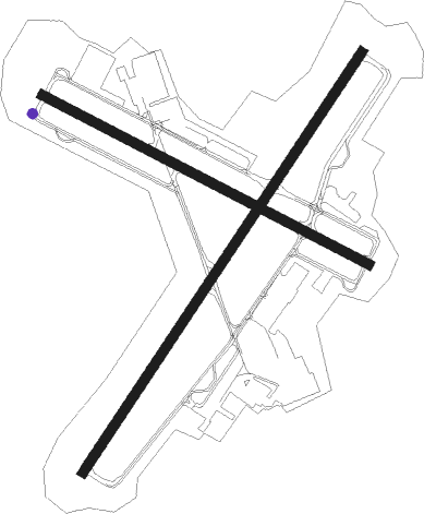
Runway info
Runway 5 / 23  | ||
| length | 1528m (5013ft) | |
| bearing | 47° / 227° | |
| width | 30m (98ft) | |
| surface | asphalt | |
| Runway 14 / 32 | ||
| length | 1115m (3658ft) | |
| bearing | 114° / 294° | |
| width | 30m (100ft) | |
| surface | asphalt | |
| displ threshold | 0m (0ft) / 25m (82ft) | |
Nearby beacons
| code | identifier | dist | bearing | frequency |
|---|---|---|---|---|
| LWM | DME | 1.8 | 51° | 112.50 |
| MHT | MANCHESTER VOR/DME | 14.1 | 302° | 114.40 |
| MJ | FITZY (MANCHESTER) NDB | 19.9 | 290° | 209 |
| BOS | BOSTON VOR/DME | 22.4 | 160° | 112.70 |
| PSM | (PORTSMOUTH) DME | 25.5 | 38° | 116.50 |
| CO | EPSOM (CONCORD) NDB | 28.1 | 321° | 216 |
| ESG | ROLLINS (ROLLINSFORD) NDB | 32.8 | 30° | 260 |
| OW | STOGE (NORWOOD) NDB | 35.8 | 180° | 397 |
| CON | CONCORD VOR/DME | 36.1 | 318° | 112.90 |
| SF | SANFD (SANFORD) NDB | 39.1 | 25° | 349 |
| GDM | GARDNER VOR/DME | 42.5 | 260° | 110.60 |
| ENE | KENNEBUNK VOR/DME | 48 | 36° | 117.10 |
| LC | BLNAP (LACONIA) NDB | 52.4 | 333° | 328 |
| PVC | PROVINCETOWN NDB | 55.7 | 126° | 389 |
| PUT | PUTNAM VOR/DME | 55.8 | 223° | 117.40 |
| PVD | PROVIDENCE VOR/DME | 61.1 | 197° | 115.60 |
Departure and arrival routes
| Transition altitude | 18000ft |
| Transition level | 18000ft |
| SID end points | distance | outbound heading | |
|---|---|---|---|
| RW05 | |||
| LWM1 | 37mi | 229° | |
| RW14 | |||
| LWM1 | 37mi | 229° | |
| RW23 | |||
| LWM1 | 37mi | 229° | |
| RW32 | |||
| LWM1 | 37mi | 229° | |
| STAR starting points | distance | inbound heading | |
|---|---|---|---|
| ALL | |||
| GRAYM6 | 54.6 | 56° | |
| DREEM2 | 34.7 | 60° | |
| ZELKA2 | 23.2 | 63° | |
Instrument approach procedures
| runway | airway (heading) | route (dist, bearing) |
|---|---|---|
| RW05 | BOS (340°) | BOS KENEE (14mi, 298°) 2000ft TEWKS (5mi, 351°) 2000ft |
| RW05 | SOSYO (53°) | SOSYO TEWKS (9mi, 60°) 2000ft |
| RW05 | TEWKS (47°) | TEWKS 2000ft |
| RW05 | WEPSO (63°) | WEPSO TEWKS (7mi, 85°) 2000ft |
| RNAV | TEWKS 2000ft WOBMU (5mi, 47°) 1900ft GRAPS (4mi, 47°) 720ft KLWM (2mi, 46°) 191ft (4579mi, 121°) 700ft WITCH (4568mi, 301°) 3000ft WITCH (turn) 3000ft | |
| RW23 | NUBRY (256°) | NUBRY TUNUY (7mi, 300°) 2100ft |
| RW23 | TUNUY (227°) | TUNUY 2100ft |
| RW23 | WIPNO (188°) | WIPNO TUNUY (7mi, 120°) 2100ft |
| RNAV | TUNUY 2100ft WUMUP (7mi, 227°) 1400ft KLWM (4mi, 227°) 189ft (4579mi, 121°) 548ft TEWKS (4584mi, 301°) 2000ft TEWKS (turn) |
Holding patterns
| STAR name | hold at | type | turn | heading* | altitude | leg | speed limit |
|---|---|---|---|---|---|---|---|
| DREEM2 | DREEM | VHF | left | 233 (53)° | 1.0min timed | ICAO rules | |
| GRAYM6 | DREEM | VHF | left | 233 (53)° | 1.0min timed | ICAO rules | |
| *) magnetic outbound (inbound) holding course | |||||||
Disclaimer
The information on this website is not for real aviation. Use this data with the X-Plane flight simulator only! Data taken with kind consent from X-Plane 12 source code and data files. Content is subject to change without notice.