Orlando - Orlando Sanford
Airport details
| Country | United States of America |
| State | Florida |
| Region | K7 |
| Airspace | Jacksonville Ctr |
| Municipality | Sanford |
| Elevation | 55ft (17m) |
| Timezone | GMT -5 |
| Coordinates | 28.77697, -81.23492 |
| Magnetic var | |
| Type | land |
| Available since | X-Plane v10.40 |
| ICAO code | KSFB |
| IATA code | SFB |
| FAA code | SFB |
Communication
| Orlando Sanford ATIS | 125.975 |
| Orlando Sanford CTAF | 120.300 |
| Orlando Sanford Clearance DEL | 123.975 |
| Orlando Sanford Ground Control | 121.350 |
| Orlando Sanford SANFORD Tower | 120.300 |
| Orlando Sanford SANFORD Tower | 135.250 |
| Orlando Sanford Approach/Departure | 119.775 |
Approach frequencies
| ILS-cat-I | RW27R | 110.15 | 18.00mi |
| ILS-cat-I | RW09R | 111.55 | 18.00mi |
| ILS-cat-I | RW09L | 108.9 | 18.00mi |
| 3° GS | RW27R | 110.15 | 18.00mi |
| 3° GS | RW09R | 111.55 | 18.00mi |
| 3° GS | RW09L | 108.9 | 18.00mi |
Nearby Points of Interest:
St. James A. M. E. Church
-Sanford Residential Historic District
-Sanford Grammar School
-Old Fernald-Laughton Memorial Hospital
-Sanford Commercial District
-Lake Mary Chamber of Commerce Building
-Browne-King House
-R. W. Estes Celery Company Precooler Historic District
-Wheeler-Evans House
-Longwood Historic District
-Bradlee-McIntyre House
-Siegmund and Marilyn Goldman House
-Orange City Town Hall
-Seth French House
-Southern Cassadaga Spiritualist Camp Historic District
-Ann Stevens House
-Comstock-Harris House
-William H. Waterhouse House
-Edward Hill Brewer House
-Winter Park Country Club and Golf Course
-Robert Bruce Barbour House
-Interlachen Avenue Historic District
-Lake Helen Historic District
-Thomas Picton Warlow, Sr., House
-Rosemere Historic District
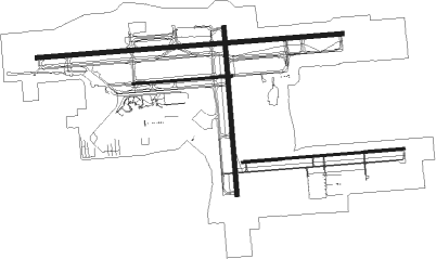
Runway info
Runway 9C / 27C  | ||
| length | 1089m (3573ft) | |
| bearing | 90° / 270° | |
| width | 23m (75ft) | |
| surface | asphalt | |
| blast zone | 15m (49ft) / 15m (49ft) | |
| Runway 9R / 27L | ||
| length | 1781m (5843ft) | |
| bearing | 90° / 270° | |
| width | 23m (75ft) | |
| surface | asphalt | |
| displ threshold | 256m (840ft) / 0m (0ft) | |
| blast zone | 61m (200ft) / 0m (0ft) | |
| Runway 9L / 27R | ||
| length | 3348m (10984ft) | |
| bearing | 90° / 270° | |
| width | 46m (150ft) | |
| surface | asphalt | |
| displ threshold | 305m (1001ft) / 0m (0ft) | |
| blast zone | 255m (837ft) / 122m (400ft) | |
| Runway 18 / 36 | ||
| length | 1836m (6024ft) | |
| bearing | 180° / 360° | |
| width | 46m (150ft) | |
| surface | asphalt | |
| blast zone | 61m (200ft) / 61m (200ft) | |
Nearby beacons
| code | identifier | dist | bearing | frequency |
|---|---|---|---|---|
| ORL | ORLANDO VORTAC | 15 | 203° | 112.20 |
| OR | HERNY (ORLANDO) NDB | 19.3 | 216° | 221 |
| OMN | ORMOND BEACH VORTAC | 32.2 | 13° | 112.60 |
| COF | PATRICK (COCOA) TACAN | 46.1 | 131° | 115 |
| MLB | MELBOURNE VOR/DME | 51.2 | 138° | 115.85 |
| OCF | OCALA VORTAC | 57.3 | 292° | 113.70 |
| LAL | LAKELAND VORTAC | 62.8 | 225° | 116 |
| GN | WYNDS (GAINESVILLE) NDB | 72.7 | 314° | 269 |
Departure and arrival routes
| Transition altitude | 18000ft |
| Transition level | 18000ft |
| SID end points | distance | outbound heading | |
|---|---|---|---|
| RW09 (ALL) | |||
| SFB1 | 23mi | 95° | |
| RW18 | |||
| SFB1 | 23mi | 95° | |
| RW27 (ALL) | |||
| SFB1 | 23mi | 95° | |
| RW36 | |||
| SFB1 | 23mi | 95° | |
| STAR starting points | distance | inbound heading | |
|---|---|---|---|
| ALL | |||
| JOKRS2 | 51.5 | 33° | |
| MINEE5 | 47.8 | 38° | |
| PRICY1 | 58.0 | 45° | |
| SHREK2 | 38.2 | 108° | |
| TTHOR2 | 53.3 | 180° | |
| ALYNA1 | 10.7 | 268° | |
| RIDES1 | 52.1 | 351° | |
| GOOFY7 | 50.1 | 352° | |
Instrument approach procedures
| runway | airway (heading) | route (dist, bearing) |
|---|---|---|
| RW09L | IPNEC (64°) | IPNEC 2800ft UGMAH (7mi, 360°) 2000ft |
| RW09L | UDUZI (115°) | UDUZI 2800ft UGMAH (6mi, 180°) 2000ft |
| RW09L | UGMAH (91°) | UGMAH 2000ft |
| RNAV | UGMAH 2000ft OLNAF (6mi, 90°) 1600ft CUNPA (3mi, 90°) 600ft KSFB (3mi, 96°) 110ft (4944mi, 110°) 255ft UXFIM (4932mi, 290°) 1600ft UXFIM (turn) | |
| RW09R | IPNEC (64°) | IPNEC 2800ft JORVU (6mi, 360°) 2000ft |
| RW09R | JORVU (88°) | JORVU 2000ft |
| RW09R | UDUZI (115°) | UDUZI 2800ft JORVU (7mi, 180°) 2000ft |
| RNAV | JORVU 2000ft COYVA (7mi, 90°) 1600ft KSFB (5mi, 85°) 84ft (4944mi, 110°) 239ft WEPAT (4933mi, 290°) 1600ft WEPAT (turn) | |
| RW18 | DIGGR (194°) | DIGGR GOPCE (7mi, 216°) 2000ft |
| RW18 | SMYRA (227°) | SMYRA GOPCE (13mi, 260°) 2000ft |
| RW18 | WORMS (148°) | WORMS GOPCE (8mi, 108°) 2000ft |
| RNAV | GOPCE 2000ft ZUBAV (6mi, 180°) 1600ft KSFB (5mi, 180°) 93ft (4944mi, 110°) 600ft GOPCE (4945mi, 290°) 2100ft GOPCE (turn) | |
| RW27L | GACNO (293°) | GACNO WEPAT (6mi, 345°) 1600ft |
| RW27L | SMYRA (227°) | SMYRA VOFOS (8mi, 182°) 2000ft WEPAT (6mi, 191°) 1600ft |
| RW27L | WEPAT (272°) | WEPAT 1600ft |
| RNAV | WEPAT 1600ft ONBEW (6mi, 270°) 1600ft LOBPI (3mi, 270°) 700ft KSFB (3mi, 277°) 69ft (4944mi, 110°) 420ft JORVU (4956mi, 289°) 2000ft JORVU (turn) | |
| RW27R | GACNO (293°) | GACNO UXFIM (7mi, 351°) 1600ft |
| RW27R | SMYRA (227°) | SMYRA VOFOS (8mi, 182°) 2000ft UXFIM (5mi, 187°) 1600ft |
| RW27R | UXFIM (269°) | UXFIM 1600ft |
| RNAV | UXFIM 1600ft UTIMY (6mi, 270°) 1600ft KSFB (5mi, 267°) 86ft (4944mi, 110°) 245ft UGMAH (4956mi, 289°) 2000ft UGMAH (turn) |
Holding patterns
| STAR name | hold at | type | turn | heading* | altitude | leg | speed limit |
|---|---|---|---|---|---|---|---|
| ALYNA1 | GRDON | VHF | right | 19 (199)° | DME 10.0mi | ICAO rules | |
| ALYNA1 | SURFR | VHF | left | 79 (259)° | DME 10.0mi | ICAO rules | |
| ALYNA1 | TIMIE | VHF | left | 19 (199)° | DME 10.0mi | ICAO rules | |
| GOOFY7 | BAIRN | VHF | right | 162 (342)° | < 17999ft | 1.0min timed | ICAO rules |
| JOKRS2 | FAZES | VHF | left | 169 (349)° | DME 10.0mi | ICAO rules | |
| JOKRS2 | MOANS | VHF | left | 183 (3)° | < 17999ft | 1.0min timed | ICAO rules |
| MINEE5 | DOWNN | VHF | left | 183 (3)° | 1.0min timed | ICAO rules | |
| MINEE5 | MINEE | VHF | right | 240 (60)° | < 17999ft | 1.0min timed | ICAO rules |
| MINEE5 | MOANS | VHF | left | 183 (3)° | < 17999ft | 1.0min timed | ICAO rules |
| PRICY1 | CHIVE | VHF | right | 273 (93)° | DME 10.0mi | ICAO rules | |
| PRICY1 | DAAWG | VHF | right | 272 (92)° | DME 10.0mi | ICAO rules | |
| PRICY1 | DECKS | VHF | right | 276 (96)° | DME 10.0mi | ICAO rules | |
| PRICY1 | DOZES | VHF | right | 250 (70)° | DME 10.0mi | ICAO rules | |
| PRICY1 | PRICY | VHF | right | 252 (72)° | DME 10.0mi | ICAO rules | |
| RIDES1 | RIDES | VHF | left | 164 (344)° | DME 10.0mi | ICAO rules | |
| RIDES1 | ZALUP | VHF | right | 125 (305)° | DME 10.0mi | ICAO rules | |
| SHREK2 | BITTE | VHF | right | 304 (124)° | DME 10.0mi | ICAO rules | |
| SHREK2 | WANDD | VHF | right | 310 (130)° | DME 10.0mi | ICAO rules | |
| TTHOR2 | LPERD | VHF | right | 14 (194)° | DME 10.0mi | ICAO rules | |
| TTHOR2 | WEEEK | VHF | left | 2 (182)° | DME 10.0mi | ICAO rules | |
| *) magnetic outbound (inbound) holding course | |||||||
Disclaimer
The information on this website is not for real aviation. Use this data with the X-Plane flight simulator only! Data taken with kind consent from X-Plane 12 source code and data files. Content is subject to change without notice.