Santa Ana - Orange County - John Wayne
Airport details
| Country | United States of America |
| State | California |
| Region | K2 |
| Airspace | Los Angeles Ctr |
| Municipality | Orange County |
| Elevation | 56ft (17m) |
| Timezone | GMT -8 |
| Coordinates | 33.67567, -117.86823 |
| Magnetic var | |
| Type | land |
| Available since | X-Plane v10.40 |
| ICAO code | KSNA |
| IATA code | SNA |
| FAA code | SNA |
Communication
| Orange County - John Wayne ATIS | 126.000 |
| Orange County - John Wayne CTAF | 126.800 |
| Orange County - John Wayne UNICOM | 122.950 |
| Orange County - John Wayne CLEARANCE DELIVERY | 118.000 |
| Orange County - John Wayne GROUND EAST | 132.250 |
| Orange County - John Wayne GROUND WEST | 120.800 |
| Orange County - John Wayne TOWER 02R/20L | 119.900 |
| Orange County - John Wayne TOWER 02L/20R | 126.800 |
| Orange County - John Wayne SOCAL ApproachROACH | 121.300 |
| Orange County - John Wayne SOCAL DepartureARTURE | 128.100 |
| Orange County - John Wayne SOCAL DepartureARTURE | 132.700 |
Approach frequencies
| LDA | RW20R | 108.3 | 18.00mi |
| ILS-cat-I | RW20R | 111.75 | 18.00mi |
| 3° GS | RW20R | 111.75 | 18.00mi |
Nearby Points of Interest:
Santa Ana Army Air Base
-Marine Corps Air Station Tustin
-Santora Building
-Builders Exchange Building
-Odd Fellows Hall
-USS YMS-328
-Pacific Electric Sub-Station No. 14
-Old Orange County Courthouse
-Howe-Waffle House and Carriage House
-Balboa Pavilion
-Santa Ana Fire Station Headquarters No. 1
-Lovell Beach House
-Frances Packing House
-Old Towne Orange Historic District
-Cypress Street Schoolhouse
-C. Z. Culver House
-First Baptist Church of Orange
-Lewis Ainsworth House
-Helme-Worthy Store and Residence
-St. Francis by-the-Sea American Catholic Church
-Irvine Park
-Irvine Ranch Natural Landmarks
-Jose Serrano Adobe
-Phillip Ackley Stanton House
-Elephant Packing House
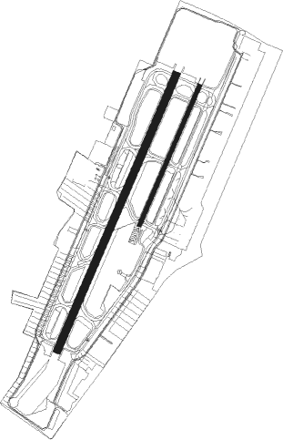
Runway info
Runway 2L / 20R  | ||
| length | 1740m (5709ft) | |
| bearing | 32° / 212° | |
| width | 46m (150ft) | |
| surface | asphalt | |
| blast zone | 255m (837ft) / 61m (200ft) | |
| Runway 2R / 20L | ||
| length | 881m (2890ft) | |
| bearing | 32° / 212° | |
| width | 23m (75ft) | |
| surface | asphalt | |
| blast zone | 123m (404ft) / 46m (151ft) | |
Nearby beacons
| code | identifier | dist | bearing | frequency |
|---|---|---|---|---|
| ELB | EL TORO (SANTA ANA) VOR/DME | 6.8 | 90° | 117.20 |
| SLI | SEAL BEACH (LOS ALAMITOS) VORTAC | 11.3 | 300° | 115.70 |
| PDZ | PARADISE (ONTARIO) VORTAC | 22.3 | 54° | 112.20 |
| POM | POMONA VORTAC | 24.5 | 11° | 110.40 |
| RAL | RIVERSIDE VOR | 26.7 | 56° | 112.40 |
| LAX | LOS ANGELES VORTAC | 32.1 | 295° | 113.60 |
| RIV | MARCH (RIVERSIDE) TACAN | 32.6 | 69° | 113 |
| SXC | SANTA CATALINA VORTAC | 32.9 | 241° | 111.40 |
| SB | PETIS (SAN BERNARDINO) NDB | 33.9 | 53° | 397 |
| NFG | CAMP PENDLETON (OCEANSIDE TACAN | 34.1 | 130° | 111.80 |
| OCN | OCEANSIDE VORTAC | 34.5 | 134° | 115.30 |
| HDF | HOMELAND (RIVERSIDE) VOR | 34.6 | 82° | 113.40 |
| SMO | SANTA MONICA VOR/DME | 35.5 | 300° | 110.80 |
| VNY | VAN NUYS VOR/DME | 45.2 | 311° | 113.10 |
| NUC | SAN CLEMENTE TACAN | 52.8 | 228° | 117.60 |
| NSD | BEAVER (SAN DIEGO) TACAN | 55.7 | 216° | 113.90 |
| PMD | PALMDALE VORTAC | 58.2 | 348° | 114.50 |
| VCV | VICTORVILLE VOR/DME | 60 | 28° | 109.05 |
| NKX | MIRAMAR (SAN DIEGO) TACAN | 60.2 | 138° | 109.60 |
| MZB | MISSION BAY (SAN DIEGO) VORTAC | 62.6 | 144° | 117.80 |
| NZY | NORTH ISLAND (SAN DIEGO) TACAN | 67 | 146° | 117 |
Departure and arrival routes
| Transition altitude | 18000ft |
| Transition level | 18000ft |
| SID end points | distance | outbound heading | |
|---|---|---|---|
| ALL | |||
| ANAHM1 | 65mi | 290° | |
| RW02L | |||
| HOBOW3 | 94mi | 43° | |
| ELB4 | 85mi | 92° | |
| PIGGN2 | 87mi | 122° | |
| MIKAA1 | 32mi | 256° | |
| HAWWC3 | 63mi | 292° | |
| IRV5 | 11mi | 300° | |
| RW20R | |||
| FINZZ3 | 94mi | 43° | |
| MUSEL8 | 85mi | 92° | |
| PIGGN2, STAYY3 | 87mi | 122° | |
| HAWWC3 | 63mi | 292° | |
| CHANL3 | 107mi | 294° | |
| HHERO3 | 60mi | 313° | |
| STAR starting points | distance | inbound heading | |
|---|---|---|---|
| ALL | |||
| TANDY5 | 49.7 | 112° | |
| KAYOH7 | 15.2 | 249° | |
| DSNEE5 | 22.6 | 251° | |
| ROOBY3 | 30.3 | 254° | |
| RW02L | |||
| TILLT2 | 45.7 | 83° | |
| OHSEA2 | 37.1 | 84° | |
| RW20R | |||
| TILLT2 | 45.7 | 83° | |
| OHSEA2 | 37.1 | 84° | |
Instrument approach procedures
| runway | airway (heading) | route (dist, bearing) |
|---|---|---|
| RW02LZ | FYTRR (302°) | FYTRR 4000ft ARMBR (5mi, 258°) 4000ft OSOYI (3mi, 258°) 3200ft NEWPO (5mi, 317°) 1600ft |
| RW02LZ | MINOE (32°) | MINOE 3000ft NEWPO (6mi, 32°) 1600ft |
| RNAV | NEWPO 1600ft KSNA (5mi, 33°) 111ft (6780mi, 106°) 800ft SLI (6787mi, 286°) 2600ft SLI (turn) | |
| RW20RZ | DSNEE (251°) | DSNEE 8000ft BONVY (7mi, 276°) 6000ft DEKRT (5mi, 270°) 4600ft AMELE (2mi, 270°) 4200ft EHVOX (3mi, 270°) 3300ft FEBTA (4mi, 212°) 2200ft WEMDO (turn) 1900ft ZETOV (2mi, 212°) 1400ft |
| RW20RZ | KLEVR (105°) | KLEVR 5000ft MNNIE (2mi, 32°) 4400ft KLIPP (3mi, 32°) 3400ft CALIT (4mi, 106°) 1600ft ZETOV (turn) 1400ft |
| RNAV | ZETOV 1400ft KSNA (5mi, 212°) 93ft MINOE (12mi, 212°) 3000ft |
Holding patterns
| STAR name | hold at | type | turn | heading* | altitude | leg | speed limit |
|---|---|---|---|---|---|---|---|
| DSNEE5 | LITNG | VHF | left | 84 (264)° | DME 10.0mi | ICAO rules | |
| DSNEE5 | SCROW | VHF | left | 59 (239)° | DME 10.0mi | ICAO rules | |
| ROOBY3 | LITNG | VHF | left | 84 (264)° | DME 10.0mi | ICAO rules | |
| ROOBY3 | SCROW | VHF | left | 59 (239)° | DME 10.0mi | ICAO rules | |
| *) magnetic outbound (inbound) holding course | |||||||
Disclaimer
The information on this website is not for real aviation. Use this data with the X-Plane flight simulator only! Data taken with kind consent from X-Plane 12 source code and data files. Content is subject to change without notice.