Sofia
Airport details
| Country | Bulgaria |
| State | Sofia Province |
| Region | LB |
| Airspace | Sofia Ctr |
| Municipality | Sofia |
| Elevation | 1742ft (531m) |
| Timezone | GMT +2 |
| Coordinates | 42.69987, 23.40398 |
| Magnetic var | |
| Type | land |
| Available since | X-Plane v10.40 |
| ICAO code | LBSF |
| IATA code | SOF |
| FAA code | n/a |
Communication
| Sofia ATIS | 126.680 |
| Sofia Tower | 128.810 |
| Sofia Approach | 129.900 |
| Sofia Departure | 123.700 |
Approach frequencies
| ILS-cat-III | RW27 | 109.5 | 18.00mi |
| ILS-cat-I | RW09 | 110.7 | 18.00mi |
| 3° GS | RW27 | 109.5 | 18.00mi |
| 3° GS | RW09 | 110.7 | 18.00mi |
Nearby Points of Interest:
Smedovski's house
-Fingov's house
-Shismanov's house
-Strawberry House
-Georgov's House
-Stanishev's House
-Funk house, Sofia
-Main Astronomical Point of Bulgaria
-Modern Theater, Sofia
-Saint George Church, Trudovets
-Bozhenishki Urvich
-Vrachanski Karst
Runway info
| Runway 09 / 27 | ||
| length | 3587m (11768ft) | |
| bearing | 93° / 273° | |
| width | 45m (148ft) | |
| surface | asphalt | |
| displ threshold | 300m (984ft) / 0m (0ft) | |
| blast zone | 119m (390ft) / 120m (394ft) | |
Airport layout
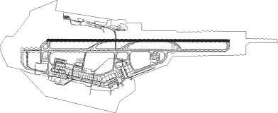
Taxiway locations
Parking locations
|
Nearby beacons
| code | identifier | dist | bearing | frequency |
|---|---|---|---|---|
| SOF | SOFIA VOR/DME | 0.6 | 263° | 112.60 |
| VIT | DME | 9.5 | 220° | 113.45 |
| BOZ | BOZHOURISHTE NDB | 10.2 | 288° | 312 |
| WAK | VAKAREL NDB | 15.2 | 113° | 490 |
| BLO | BAILOVO VOR/DME | 18.2 | 95° | 117.50 |
| KAL | DME | 27.6 | 295° | 117.55 |
| GOL | GOLYAMA VOR/DME | 43 | 64° | 114.10 |
Departure and arrival routes
| Transition altitude | 12000ft |
| Transition level | 14000ft |
| SID end points | distance | outbound heading | |
|---|---|---|---|
| RW09 | |||
| UMPI3S, UMPI2V | 34mi | 84° | |
| GAPV2S, GAPV2V | 33mi | 91° | |
| DEDI2S, DEDI2V | 31mi | 99° | |
| RUME6A, RUME2S | 47mi | 113° | |
| DILV5A, DILV2S | 33mi | 126° | |
| OMEN3V, OMEN2S | 24mi | 169° | |
| NAPE3A, NAPE2S | 30mi | 224° | |
| GODE5A, GODE3S | 31mi | 316° | |
| OGOT5A, OGOT3S | 31mi | 351° | |
| RW27 | |||
| UMPI2W, UMPI2T | 34mi | 84° | |
| GAPV2T, GAPV2W | 33mi | 91° | |
| DEDI2T, DEDI2W | 31mi | 99° | |
| RUME3W, RUME2T | 47mi | 113° | |
| DILV2T, DILV2W | 33mi | 126° | |
| OMEN2W, OMEN2T | 24mi | 169° | |
| NAPE2T, NAPE3E | 30mi | 224° | |
| GODE5E, GODE2T | 31mi | 316° | |
| OGOT2T, OGOT5E | 31mi | 351° | |
| STAR starting points | distance | inbound heading | |
|---|---|---|---|
| RW09 | |||
| MORE4D | 24.7 | 12° | |
| NISV4D | 31.3 | 114° | |
| UMPI4D | 34.3 | 264° | |
| GAPV4D | 32.7 | 271° | |
| DEDI4D | 30.5 | 279° | |
| RUME4D | 46.7 | 293° | |
| VANE4D | 24.3 | 359° | |
| RW27 | |||
| MORE4H | 24.7 | 12° | |
| NISV3K, NISV4H | 31.3 | 114° | |
| UMPI4H | 34.3 | 264° | |
| GAPV3H | 32.7 | 271° | |
| DEDI4H | 30.5 | 279° | |
| RUME4H | 46.7 | 293° | |
| VANE4H | 24.3 | 359° | |
Instrument approach procedures
| runway | airway (heading) | route (dist, bearing) |
|---|---|---|
| RW09 | BENGO (93°) | BENGO 7000ft LUXUV (4mi, 93°) 6100ft |
| RNAV | LUXUV 6100ft MAGUP (8mi, 93°) 4100ft LBSF (7mi, 92°) 1789ft SF450 (7mi, 94°) (2861mi, 209°) 4500ft SOF (2858mi, 29°) 8000ft SOF (turn) 8000ft | |
| RW27 | RUBIV (274°) | RUBIV 6000ft BAGIP (5mi, 274°) 4100ft |
| RNAV | BAGIP 4100ft TUTPO (4mi, 274°) 3600ft LBSF (7mi, 274°) 1795ft SOF (turn) BOZ (10mi, 290°) BENGO (10mi, 258°) 8000ft |
Holding patterns
| STAR name | hold at | type | turn | heading* | altitude | leg | speed limit |
|---|---|---|---|---|---|---|---|
| DEDI4D | BENGO | VHF | right | 269 (89)° | 6100ft - 14000ft | 1.0min timed | ICAO rules |
| GAPV4D | BENGO | VHF | right | 269 (89)° | 6100ft - 14000ft | 1.0min timed | ICAO rules |
| GOL3H | ETRIL | VHF | left | 30 (210)° | 8000ft - 10000ft | 1.0min timed | 210 |
| GOL3H | GOL | NDB | right | 331 (151)° | 17000ft - 23000ft | 1.5min timed | 265 |
| GOL3H | LANGI | VHF | left | 328 (148)° | 8000ft - 10000ft | 1.0min timed | 230 |
| GOL4D | BENGO | VHF | right | 269 (89)° | 6100ft - 14000ft | 1.0min timed | ICAO rules |
| GOL4D | GOL | NDB | right | 331 (151)° | 17000ft - 23000ft | 1.5min timed | 265 |
| MORE4D | BENGO | VHF | right | 269 (89)° | 6100ft - 14000ft | 1.0min timed | ICAO rules |
| NISV4D | BENGO | VHF | right | 269 (89)° | 6100ft - 14000ft | 1.0min timed | ICAO rules |
| RUME4D | BENGO | VHF | right | 269 (89)° | 6100ft - 14000ft | 1.0min timed | ICAO rules |
| UMPI4D | BENGO | VHF | right | 269 (89)° | 6100ft - 14000ft | 1.0min timed | ICAO rules |
| VANE4D | BENGO | VHF | right | 269 (89)° | 6100ft - 14000ft | 1.0min timed | ICAO rules |
| *) magnetic outbound (inbound) holding course | |||||||
Disclaimer
The information on this website is not for real aviation. Use this data with the X-Plane flight simulator only! Data taken with kind consent from X-Plane 12 source code and data files. Content is subject to change without notice.