Klagenfurt Am Wörthersee - Klagenfurt
Airport details
| Country | Austria |
| State | Carinthia |
| Region | LO |
| Airspace | Vienna Ctr |
| Municipality | Klagenfurt |
| Elevation | 1470ft (448m) |
| Timezone | GMT +1 |
| Coordinates | 46.64774, 14.32709 |
| Magnetic var | |
| Type | land |
| Available since | X-Plane v10.40 |
| ICAO code | LOWK |
| IATA code | KLU |
| FAA code | n/a |
Communication
| Klagenfurt ATIS | 126.330 |
| Klagenfurt Tower | 118.100 |
| Klagenfurt Approach | 126.825 |
Approach frequencies
| ILS-cat-III | RW28R | 110.1 | 18.00mi |
| 3° GS | RW28R | 110.1 | 18.00mi |
Nearby Points of Interest:
Sankt Georgen am Sandhof
-Schloss Pichlern, Klagenfurt
-Schloss Ehrenhausen, Klagenfurt
-Rektoratskirche St. Elisabeth, Klagenfurt
-Hemma of Gurk Church
-Klagenfurt, Handelsakademie
-Altes Rathaus, Klagenfurt
-Dreifaltigkeitssäule
-Palais Goess in Klagenfurt
-Burg
-Palais Christalnig in Klagenfurt
-Landhaus Klagenfurt
-Viktringerhof
-Rathaus Klagenfurt
-Konzerthaus Klagenfurt
-Schloss Harbach
-Pfarrkirche Klagenfurt-St. Modestus
-Steinerner Fischer
-Pfarrkirche hl. Jakobus major, Hörtendorf (Klagenfurt)
-Volxhaus
-Jewish cemetery in Klagenfurt
-Schloss Gundersdorf
-Schloss Rosenegg, Ebenthal
-Duke's Chair
-Schloss Lind, Maria Saal
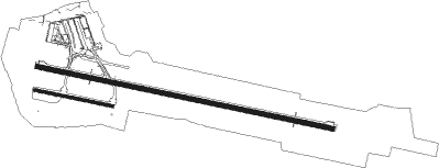
Runway info
Runway 10L / 28R  | ||
| length | 2712m (8898ft) | |
| bearing | 101° / 281° | |
| width | 45m (148ft) | |
| surface | concrete | |
| displ threshold | 198m (650ft) / 0m (0ft) | |
| Runway 10R / 28L | ||
| length | 709m (2326ft) | |
| bearing | 101° / 281° | |
| width | 27m (89ft) | |
| surface | grass | |
| displ threshold | 99m (325ft) / 100m (328ft) | |
Nearby beacons
| code | identifier | dist | bearing | frequency |
|---|---|---|---|---|
| KI | KLAGENFURT NDB | 2.4 | 104° | 313 |
| KFT | KLAGENFURT NDB | 8.6 | 96° | 374 |
| KFT | KLAGENFURT VOR/DME | 10.1 | 102° | 113.10 |
| VIW | DME | 17.2 | 277° | 112.90 |
| LBL | LJUBLJANA VOR/DME | 24.9 | 166° | 117.20 |
| KOR | DME | 27.8 | 78° | 109.40 |
| MG | LJUBLJANA NDB | 30 | 154° | 296 |
| ZW | ZELTWEG NDB | 37.4 | 38° | 418 |
| DOL | DOLSKO VOR/DME | 38.6 | 141° | 112.70 |
| RCH | RONCHI DEI LEGIONARI VOR/DME | 60.4 | 226° | 114.20 |
| RON | RONCHI DEI LEGIONARI NDB | 63.4 | 230° | 396 |
Departure and arrival routes
| Transition altitude | 9000ft |
| SID end points | distance | outbound heading | |
|---|---|---|---|
| RW10L | |||
| ABIR1L | 27mi | 80° | |
| KLAG1L | 20mi | 107° | |
| BERT1L | 17mi | 124° | |
| REKT1L | 18mi | 262° | |
| VILA1L | 17mi | 277° | |
| INGI2L | 46mi | 314° | |
| RW28R | |||
| ABIR1R | 27mi | 80° | |
| KLAG1R | 20mi | 107° | |
| BERT1R | 17mi | 124° | |
| REKT1R | 18mi | 262° | |
| VILA1R | 17mi | 277° | |
| INGI2R | 46mi | 314° | |
| STAR starting points | distance | inbound heading | |
|---|---|---|---|
| ALL | |||
| ARNO3A | 31.9 | 82° | |
| TISM1A | 17.1 | 147° | |
| ABIR2A, ABIR2T | 27.2 | 260° | |
| DIPS2A | 24.6 | 274° | |
| KLAG1A | 20.1 | 287° | |
| BERT1A | 17.1 | 304° | |
Instrument approach procedures
| runway | airway (heading) | route (dist, bearing) |
|---|---|---|
| RW10L | MOK1W (17°) | MOKEG 8000ft WK830 (5mi, 23°) 7000ft WK806 (11mi, 281°) 6300ft WK807 (3mi, 203°) 5400ft WK808 (3mi, 203°) 4500ft |
| RW10L | WK804 (101°) | WK804 8000ft WK802 (3mi, 101°) 6500ft WK808 (4mi, 101°) 4500ft |
| RW10L | WK806 (125°) | WK806 6300ft WK807 (3mi, 203°) 5400ft WK808 (3mi, 203°) 4500ft |
| RNAV | WK808 4500ft WK809 (2mi, 101°) 4000ft WK810 (2mi, 101°) 3300ft LOWK (5mi, 100°) 1520ft WK812 (15mi, 102°) WK824 (8mi, 45°) MOKEG (17mi, 263°) 8000ft MOKEG (turn) 8000ft | |
| RW28R | MOK2E (17°) | MOKEG 8000ft WK830 (5mi, 23°) 7000ft WK831 (10mi, 101°) 5500ft WK832 (5mi, 203°) 4000ft WK827 (2mi, 281°) 4000ft |
| RW28R | WK824 (265°) | WK824 6500ft WK827 (10mi, 248°) 4000ft |
| RNAV | WK827 4000ft WK833 (4mi, 281°) 3100ft LOWK (6mi, 283°) 1501ft WK829 (10mi, 280°) MOKEG (12mi, 101°) WK827 (8mi, 101°) MOKEG (8mi, 281°) 8000ft MOKEG (turn) 8000ft |
Holding patterns
| STAR name | hold at | type | turn | heading* | altitude | leg | speed limit |
|---|---|---|---|---|---|---|---|
| ABIR2A | MOKEG | VHF | right | 103 (283)° | > 8000ft | 1.0min timed | ICAO rules |
| ARNO3A | MOKEG | VHF | right | 103 (283)° | > 8000ft | 1.0min timed | ICAO rules |
| BERT1A | MOKEG | VHF | right | 103 (283)° | > 8000ft | 1.0min timed | ICAO rules |
| DIPS2A | MOKEG | VHF | right | 103 (283)° | > 8000ft | 1.0min timed | ICAO rules |
| EVAX1A | MOKEG | VHF | right | 103 (283)° | > 8000ft | 1.0min timed | ICAO rules |
| KLAG1A | MOKEG | VHF | right | 103 (283)° | > 8000ft | 1.0min timed | ICAO rules |
| TISM1A | MOKEG | VHF | right | 103 (283)° | > 8000ft | 1.0min timed | ICAO rules |
| *) magnetic outbound (inbound) holding course | |||||||
Disclaimer
The information on this website is not for real aviation. Use this data with the X-Plane flight simulator only! Data taken with kind consent from X-Plane 12 source code and data files. Content is subject to change without notice.