Sion
Airport details
| Country | Switzerland |
| State | Wallis |
| Region | LS |
| Airspace | Switzerland Ctr |
| Municipality | Sion |
| Elevation | 1583ft (482m) |
| Timezone | GMT +1 |
| Coordinates | 46.21592, 7.31740 |
| Magnetic var | |
| Type | land |
| Available since | X-Plane v10.40 |
| ICAO code | LSGS |
| IATA code | SIR |
| FAA code | n/a |
Communication
| Sion LSGG ATIS Geneve | 135.575 |
| Sion Ground Control | 121.700 |
| Sion Tower | 118.275 |
| Sion SWISS MILITARY RADAR | 134.275 |
| Sion SION Approach | 122.350 |
| Sion SION Radar Approach | 126.825 |
| Sion Departure | 133.000 |
Approach frequencies
| IGS | RW25 | 110.7 | 18.00mi |
| 6° GS | RW25 | 110.7 | 18.00mi |
Nearby Points of Interest:
Nécropole néolithique du Petit-Chasseur
-Chemin des Collines, menhirs and archaeological zone
-media center Valais Sion
-state archives of the canton of Valais
-Valais Nature Museum
-Valais Art Museum
-Sion
-Hérémence
-Isérables
-Saillon
-Sierre
-monastery, church and site
-Gsteig bei Gstaad
-tower
-Fairy Rock (Crans Montana, Valais)
-Saint-Théodule
-Scierie des Planches
-Duin tower
-Bex salt mine
-Fortifications de l'Arzillier
-Pont des Planches
-Zen-Ruffinen Castle
-Saint-Triphon et Charpigny
-Liddes
-tithe house
Runway info
Runway 07 / 25  | ||
| length | 1995m (6545ft) | |
| bearing | 78° / 258° | |
| width | 40m (131ft) | |
| surface | asphalt | |
| displ threshold | 53m (174ft) / 52m (171ft) | |
| blast zone | 198m (650ft) / 198m (650ft) | |
| Runway 07L / 25R | ||
| length | 655m (2149ft) | |
| bearing | 78° / 258° | |
| width | 30m (98ft) | |
| surface | grass | |
| displ threshold | 0m (0ft) / 101m (331ft) | |
| blast zone | 54m (177ft) / 0m (0ft) | |
Airport layout - parking location J3
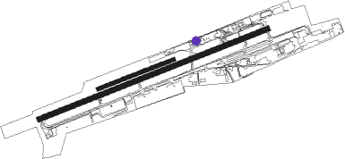
Taxiway locations
Parking locations
|
Nearby beacons
| code | identifier | dist | bearing | frequency |
|---|---|---|---|---|
| SIO | SION VOR/DME | 1.1 | 269° | 112.15 |
| SCS | AOSTA VOR/DME | 28.2 | 177° | 109.25 |
| SVC | COMAGNE (AOSTA) NDB | 32.7 | 140° | 418 |
| FRI | FRIBOURG VOR/DME | 33.9 | 351° | 110.85 |
| SPR | ST PREX VOR/DME | 39.1 | 286° | 113.90 |
| LAP | PRAZ DME | 46.5 | 297° | 110.65 |
| LPS | LES EPLATURES NDB | 56.4 | 329° | 403 |
| GRE | GRENCHEN VOR/DME | 58.2 | 6° | 115.45 |
| CSL | CASELLE VOR/DME | 61.4 | 162° | 116.75 |
| WIL | WILLISAU VOR/DME | 62.6 | 31° | 116.90 |
Departure and arrival routes
| Transition altitude | 17000ft |
| SID end points | distance | outbound heading | |
|---|---|---|---|
| RW25 | |||
| ROCA3U, ROCA3V, ROCA3W | 40mi | 235° | |
| GOLE3U, GOLE3V, GOLE3W | 33mi | 258° | |
| STAR starting points | distance | inbound heading | |
|---|---|---|---|
| ALL | |||
| VALO1W | 17.1 | 66° | |
| VADA2N | 35.3 | 128° | |
Instrument approach procedures
| runway | airway (heading) | route (dist, bearing) |
|---|---|---|
| RW25 | GRANA (253°) | GRANA 17000ft GS615 (31mi, 55°) GS616 (14mi, 126°) 17000ft |
| RNAV | GS616 17000ft GS608 (4mi, 239°) 17000ft GS607 (11mi, 240°) GS606 (4mi, 256°) GS605 (13mi, 270°) GS604 (2mi, 261°) GS617 (11mi, 252°) 1632ft GS609 (4mi, 252°) GS610 (turn) GS611 (17mi, 244°) GS612 (8mi, 342°) GS613 (11mi, 96°) SIO (9mi, 63°) GRANA (11mi, 74°) 17000ft |
Holding patterns
| STAR name | hold at | type | turn | heading* | altitude | leg | speed limit |
|---|---|---|---|---|---|---|---|
| VADA2N | GRANA | VHF | right | 246 (66)° | 17000ft - 24000ft | 1.5min timed | 220 |
| VALO1W | GRANA | VHF | right | 246 (66)° | 17000ft - 24000ft | 1.5min timed | 220 |
| *) magnetic outbound (inbound) holding course | |||||||
Disclaimer
The information on this website is not for real aviation. Use this data with the X-Plane flight simulator only! Data taken with kind consent from X-Plane 12 source code and data files. Content is subject to change without notice.