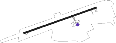
Kahramanmaraş - Kahramanmaras
Airport details
| Country | Turkey |
| State | Kahramanmaraş Province |
| Region | LT |
| Airspace | Ankara Ctr |
| Municipality | Marash |
| Elevation | 1724ft (525m) |
| Timezone | GMT +3 |
| Coordinates | 37.53833, 36.95195 |
| Magnetic var | |
| Type | land |
| Available since | X-Plane v10.40 |
| ICAO code | LTCN |
| IATA code | KCM |
| FAA code | n/a |
Communication
| Kahramanmaras Ground Control | 121.550 |
| Kahramanmaras Tower | 118.750 |
Nearby beacons
| code | identifier | dist | bearing | frequency |
|---|---|---|---|---|
| KHM | KAHRAMANMARAS NDB | 0.1 | 29° | 374 |
| GAZ | GAZIANTEP NDB | 43.1 | 138° | 432 |
Departure and arrival routes
| Transition altitude | 15000ft |
| SID end points | distance | outbound heading | |
|---|---|---|---|
| RW07 | |||
| REMP1R | 24mi | 284° | |
| RW25 | |||
| REMP1A | 24mi | 284° | |
| STAR starting points | distance | inbound heading | |
|---|---|---|---|
| ALL | |||
| POGE1A | 12.4 | 82° | |
| RW25 | |||
| POGE1B | 12.4 | 82° | |
Instrument approach procedures
| runway | airway (heading) | route (dist, bearing) |
|---|---|---|
| RW07 | REMPO (104°) | REMPO 9000ft CN071 (4mi, 107°) 7860ft MAXUT (6mi, 107°) 5960ft SONER (9mi, 115°) 3900ft |
| RNAV | SONER 3900ft CN072 (2mi, 90°) 3155ft MA07 (3mi, 90°) 1941ft DIKRU (12mi, 82°) ELKUM (5mi, 92°) BERET (7mi, 117°) NARGU (8mi, 218°) INGAM (15mi, 281°) 11000ft INGAM (turn) 11000ft | |
| RW25 | DONDU (246°) | DONDU 14000ft CN251 (8mi, 146°) 12000ft NARGU (10mi, 117°) 10000ft BERET (8mi, 38°) 8000ft ELKUM (7mi, 297°) 6400ft MAREK (5mi, 280°) 5600ft |
| RW25 | INGAM (334°) | INGAM 14000ft NARGU (15mi, 101°) 10000ft BERET (8mi, 38°) 8000ft ELKUM (7mi, 297°) 6400ft MAREK (5mi, 280°) 5600ft |
| RNAV | MAREK 5600ft CN252 (3mi, 260°) 4600ft CN253 (3mi, 260°) 3350ft MA25 (4mi, 260°) 2041ft CN461 (6mi, 276°) CN462 (5mi, 301°) CN463 (6mi, 276°) CN464 (7mi, 251°) CN465 (7mi, 223°) CN466 (9mi, 121°) INGAM (20mi, 82°) 14000ft INGAM (turn) 14000ft |
Holding patterns
| STAR name | hold at | type | turn | heading* | altitude | leg | speed limit |
|---|---|---|---|---|---|---|---|
| DOND1A | KHM | NDB | left | 136 (316)° | > 9500ft | 1.0min timed | 210 |
| INGA1G | INGAM | VHF | right | 279 (99)° | > 14000ft | 1.0min timed | ICAO rules |
| INGA1G | REMPO | VHF | right | 286 (106)° | > 9000ft | 1.0min timed | ICAO rules |
| POGE1A | KHM | NDB | left | 136 (316)° | > 9500ft | 1.0min timed | 210 |
| POGE1B | INGAM | VHF | right | 279 (99)° | > 14000ft | 1.0min timed | ICAO rules |
| *) magnetic outbound (inbound) holding course | |||||||
Disclaimer
The information on this website is not for real aviation. Use this data with the X-Plane flight simulator only! Data taken with kind consent from X-Plane 12 source code and data files. Content is subject to change without notice.
