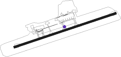
Georgetown - Owen Roberts Intl
Airport details
| Country | Cayman Islands |
| State | [Other] |
| Region | MW |
| Airspace | Kingston Ctr |
| Municipality | George Town |
| Elevation | 6ft (2m) |
| Timezone | GMT -5 |
| Coordinates | 19.29278, -81.35777 |
| Magnetic var | |
| Type | land |
| Available since | X-Plane v10.40 |
| ICAO code | MWCR |
| IATA code | GCM |
| FAA code | n/a |
Communication
| Owen Roberts Intl ATIS | 132.350 |
| Owen Roberts Intl Ground Control | 121.900 |
| Owen Roberts Intl Tower | 118.000 |
| Owen Roberts Intl GRAND CAYMAN Approach | 120.200 |
Nearby beacons
| code | identifier | dist | bearing | frequency |
|---|---|---|---|---|
| GCM | GRAND CAYMAN VOR/DME | 0.8 | 257° | 115.60 |
Departure and arrival routes
| Transition altitude | 17000ft |
| Transition level | 18000ft |
| SID end points | distance | outbound heading | |
|---|---|---|---|
| RW08 | |||
| SRAY2, RIKEL2 | 46mi | 24° | |
| KANEX2 | 56mi | 42° | |
| EEND2, TEXAM2, TURTU2 | 43mi | 75° | |
| NALRO2 | 67mi | 103° | |
| ULISA2, RBAY2 | 52mi | 234° | |
| MAMBI2 | 40mi | 283° | |
| RW26 | |||
| KANEX2 | 56mi | 42° | |
| TEXAM2 | 43mi | 75° | |
| NALRO2, SEAVI2 | 67mi | 103° | |
| ULISA2 | 52mi | 234° | |
| MAMBI2 | 40mi | 283° | |
| ATUVI1 | 43mi | 355° | |
| STAR starting points | distance | inbound heading | |
|---|---|---|---|
| ALL | |||
| GORAN3 | 10.8 | 77° | |
| GUBEL3 | 11.1 | 257° | |
| RW08 | |||
| NORTH, SOUTH | 43.1 | 255° | |
Instrument approach procedures
| runway | airway (heading) | route (dist, bearing) |
|---|---|---|
| RW08 | ATUVI (175°) | ATUVI ALONA (40mi, 192°) 1500ft MOBIX (6mi, 165°) 1500ft |
| RW08 | DELKA (32°) | DELKA MOBIX (37mi, 21°) 1500ft |
| RW08 | EMONA (4°) | EMONA VODAK (30mi, 348°) 1500ft MOBIX (6mi, 345°) 1500ft |
| RW08 | KANEX (222°) | KANEX ALONA (61mi, 232°) 1500ft MOBIX (6mi, 165°) 1500ft |
| RW08 | LEROL (23°) | LEROL MOBIX (35mi, 9°) 1500ft |
| RW08 | MAMBI (103°) | MAMBI MOBIX (32mi, 111°) 1500ft |
| RW08 | MATIS (294°) | MATIS VODAK (60mi, 283°) 1500ft MOBIX (6mi, 345°) 1500ft |
| RW08 | MOBIX (77°) | MOBIX 1500ft |
| RW08 | NALRO (283°) | NALRO VODAK (74mi, 275°) 1500ft MOBIX (6mi, 345°) 1500ft |
| RW08 | NUBIS (77°) | NUBIS MOBIX (32mi, 77°) 1500ft |
| RW08 | TEXAM (255°) | TEXAM VODAK (54mi, 249°) 1500ft MOBIX (6mi, 345°) 1500ft |
| RW08 | ULISA (54°) | ULISA MOBIX (43mi, 49°) 1500ft |
| RNAV | MOBIX 1500ft SASER (5mi, 77°) 1500ft MWCR (5mi, 77°) 58ft (4915mi, 103°) 1500ft MOBIX (4925mi, 283°) MOBIX (turn) | |
| RW26 | ATUVI (175°) | ATUVI TAGUN (36mi, 160°) 1500ft PODIS (6mi, 165°) 1500ft |
| RW26 | DELKA (32°) | DELKA OLIMA (48mi, 46°) 1500ft PODIS (6mi, 345°) 1500ft |
| RW26 | EMONA (4°) | EMONA OLIMA (37mi, 23°) 1500ft PODIS (6mi, 345°) 1500ft |
| RW26 | KANEX (222°) | KANEX PODIS (48mi, 215°) 1500ft |
| RW26 | LEROL (23°) | LEROL OLIMA (43mi, 39°) 1500ft PODIS (6mi, 345°) 1500ft |
| RW26 | MAMBI (103°) | MAMBI TAGUN (47mi, 91°) 1500ft PODIS (6mi, 165°) 1500ft |
| RW26 | MATIS (294°) | MATIS PODIS (48mi, 301°) 1500ft |
| RW26 | NALRO (283°) | NALRO PODIS (59mi, 287°) 1500ft |
| RW26 | PODIS (257°) | PODIS 1500ft |
| RW26 | RIKEL (204°) | RIKEL PODIS (41mi, 192°) 1500ft |
| RW26 | TEXAM (255°) | TEXAM PODIS (33mi, 255°) 1500ft |
| RW26 | ULISA (54°) | ULISA OLIMA (59mi, 63°) 1500ft PODIS (6mi, 345°) 1500ft |
| RNAV | PODIS 1500ft AMBOR (5mi, 257°) 1500ft MWCR (5mi, 257°) 56ft (4915mi, 103°) 1500ft PODIS (4906mi, 283°) PODIS (turn) |
Holding patterns
| STAR name | hold at | type | turn | heading* | altitude | leg | speed limit |
|---|---|---|---|---|---|---|---|
| GORAN3 | GORAN | VHF | right | 260 (80)° | > 1500ft | 1.0min timed | 230 |
| GUBEL3 | GUBEL | VHF | right | 80 (260)° | 1500ft - 60000ft | 1.0min timed | ICAO rules |
| *) magnetic outbound (inbound) holding course | |||||||
Disclaimer
The information on this website is not for real aviation. Use this data with the X-Plane flight simulator only! Data taken with kind consent from X-Plane 12 source code and data files. Content is subject to change without notice.
