Kuwait City - Kuwait Intl
Airport details
| Country | Kuwait |
| State | Farwaniya |
| Region | OK |
| Airspace | Kuwait Ctr |
| Elevation | 204ft (62m) |
| Timezone | GMT +3 |
| Coordinates | 29.22927, 47.98426 |
| Magnetic var | |
| Type | land |
| Available since | X-Plane v10.40 |
| ICAO code | OKBK |
| IATA code | KWI |
| FAA code | n/a |
Communication
| Kuwait Intl ATIS | 126.225 |
| Kuwait Intl Ground Control | 121.900 |
| Kuwait Intl Ground Control | 121.700 |
| Kuwait Intl Tower | 118.300 |
| Kuwait Intl Approach | 124.800 |
| Kuwait Intl Departure | 121.300 |
Approach frequencies
| ILS-cat-II | RW33L | 109.5 | 18.00mi |
| ILS-cat-II | RW15R | 111.3 | 18.00mi |
| ILS-cat-II | RW15L | 110.1 | 18.00mi |
| ILS-cat-II | RW33R | 110.5 | 18.00mi |
| 3° GS | RW33L | 109.5 | 18.00mi |
| 3° GS | RW15R | 111.3 | 18.00mi |
| 3° GS | RW15L | 110.1 | 18.00mi |
| 3° GS | RW33R | 110.5 | 18.00mi |
Runway info
Runway 15L / 33R  | ||
| length | 3510m (11516ft) | |
| bearing | 152° / 332° | |
| width | 45m (148ft) | |
| surface | asphalt | |
| blast zone | 120m (394ft) / 120m (394ft) | |
| Runway 15R / 33L | ||
| length | 3410m (11188ft) | |
| bearing | 152° / 332° | |
| width | 45m (148ft) | |
| surface | concrete | |
| blast zone | 65m (213ft) / 60m (197ft) | |
Airport layout
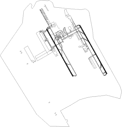
Taxiway locations
|
Parking locations
|
Nearby beacons
| code | identifier | dist | bearing | frequency |
|---|---|---|---|---|
| KUA | KUWAIT VOR/DME | 1.9 | 304° | 114.15 |
| ASB | ALI AL SALEM VORTAC | 25.3 | 284° | 116 |
| PWR | PWR (ALI AL SALEM) TACAN | 25.3 | 284° | 135.40 |
| KFR | WAFRA VOR/DME | 36.5 | 182° | 112 |
Departure and arrival routes
| Transition altitude | 13000ft |
| SID end points | distance | outbound heading | |
|---|---|---|---|
| RW15L | |||
| RALK4E | 21mi | 57° | |
| ALVA4E | 23mi | 75° | |
| SESR4E | 49mi | 95° | |
| BOXI4E | 50mi | 118° | |
| ASVI4E | 46mi | 151° | |
| KFR4E | 40mi | 212° | |
| RW15R | |||
| RALK4E | 21mi | 57° | |
| ALVA4E | 23mi | 75° | |
| SESR4E | 49mi | 95° | |
| BOXI4E | 50mi | 118° | |
| ASVI4E | 46mi | 151° | |
| KFR4E | 40mi | 212° | |
| RW33L | |||
| RALK4F | 21mi | 57° | |
| ALVA4F | 23mi | 75° | |
| SESR4F | 49mi | 95° | |
| BOXI4F | 50mi | 118° | |
| ASVI4F | 46mi | 151° | |
| KFR4F | 40mi | 212° | |
| RW33R | |||
| RALK4F | 21mi | 57° | |
| ALVA4F | 23mi | 75° | |
| SESR4F | 49mi | 95° | |
| BOXI4F | 50mi | 118° | |
| ASVI4F | 46mi | 151° | |
| KFR4F | 40mi | 212° | |
| STAR starting points | distance | inbound heading | |
|---|---|---|---|
| RW15 (ALL) | |||
| KFR3D | 36.5 | 2° | |
| SIDA3D | 47.1 | 218° | |
| RALK3D | 20.9 | 237° | |
| ALVA3D | 23.1 | 255° | |
| DESL3D | 56.5 | 257° | |
| SESR3D | 48.9 | 275° | |
| DEBT3D, DEBT3E | 39.8 | 314° | |
| ASVI3D | 46.2 | 331° | |
| KUNR3D | 42.7 | 344° | |
| RW33 (ALL) | |||
| RALK3C | 20.9 | 237° | |
| ALVA3C | 23.1 | 255° | |
| SESR3C | 48.9 | 275° | |
| RW33L | |||
| ASVI3C, DEBT3C, KFR3C, KUNR3C | 17.0 | 333° | |
| RW33R | |||
| KUNR3C, KFR3C, DEBT3C, ASVI3C | 17.0 | 333° | |
Instrument approach procedures
| runway | airway (heading) | route (dist, bearing) |
|---|---|---|
| RW15L | IVETA (126°) | IVETA 3000ft RERAN (6mi, 68°) 2400ft |
| RW15L | PASEL (190°) | PASEL 3000ft RERAN (8mi, 248°) 2400ft |
| RNAV | RERAN 2400ft FF15L (6mi, 152°) 2000ft SD15L (3mi, 152°) 1000ft OKBK (3mi, 157°) 215ft (3259mi, 239°) 1200ft LUDIM (3274mi, 59°) 5000ft | |
| RW15R | IVETA (126°) | IVETA 3000ft DATAR (5mi, 68°) 2400ft |
| RW15R | PASEL (190°) | PASEL 3000ft DATAR (9mi, 248°) 2400ft |
| RNAV | DATAR 2400ft FF15R (5mi, 152°) 2000ft SD15R (3mi, 152°) 930ft OKBK (4mi, 139°) 185ft (3259mi, 239°) 1200ft LUDIM (3274mi, 59°) 5000ft | |
| RW33L | KFR (2°) | KFR ASLUN (23mi, 360°) 3000ft RARVA (6mi, 68°) 2500ft |
| RW33L | TABTO (297°) | TABTO 3000ft RARVA (9mi, 248°) 2500ft |
| RNAV | RARVA 2500ft FF33L (6mi, 332°) 2000ft OKBK (6mi, 340°) 225ft (3259mi, 239°) 2400ft LUDIM (3274mi, 59°) 5000ft | |
| RW33R | KFR (2°) | KFR ASLUN (23mi, 360°) 3000ft GINBI (8mi, 68°) 2500ft |
| RW33R | TABTO (297°) | TABTO 3000ft GINBI (8mi, 248°) 2500ft |
| RNAV | GINBI 2500ft FF33R (5mi, 332°) 2000ft OKBK (7mi, 330°) 260ft (3259mi, 239°) 2400ft LUDIM (3274mi, 59°) 5000ft |
Holding patterns
| STAR name | hold at | type | turn | heading* | altitude | leg | speed limit |
|---|---|---|---|---|---|---|---|
| ALVA3C | TABTO | VHF | right | 62 (242)° | 3000ft - 3000ft | 1.0min timed | ICAO rules |
| ASVI3C | PEDEL | VHF | left | 152 (332)° | 3000ft - 3000ft | 1.0min timed | ICAO rules |
| ASVI3D | EMEBA | VHF | right | 152 (332)° | > 3000ft | 1.0min timed | ICAO rules |
| DEBT3C | PEDEL | VHF | left | 152 (332)° | 3000ft - 3000ft | 1.0min timed | ICAO rules |
| DEBT3E | EMEBA | VHF | right | 152 (332)° | > 3000ft | 1.0min timed | ICAO rules |
| KFR3C | PEDEL | VHF | left | 152 (332)° | 3000ft - 3000ft | 1.0min timed | ICAO rules |
| KFR3D | EMEBA | VHF | right | 152 (332)° | > 3000ft | 1.0min timed | ICAO rules |
| KUNR3C | PEDEL | VHF | left | 152 (332)° | 3000ft - 3000ft | 1.0min timed | ICAO rules |
| KUNR3D | EMEBA | VHF | right | 152 (332)° | > 3000ft | 1.0min timed | ICAO rules |
| RALK3C | TABTO | VHF | right | 62 (242)° | 3000ft - 3000ft | 1.0min timed | ICAO rules |
| RALK3D | RALKA | VHF | right | 95 (275)° | 3000ft - 46000ft | 1.0min timed | 250 |
| SESR3C | TABTO | VHF | right | 62 (242)° | 3000ft - 3000ft | 1.0min timed | ICAO rules |
| *) magnetic outbound (inbound) holding course | |||||||
Disclaimer
The information on this website is not for real aviation. Use this data with the X-Plane flight simulator only! Data taken with kind consent from X-Plane 12 source code and data files. Content is subject to change without notice.