Bogota - El Dorado Intl
Airport details
| Country | Colombia |
| State | Cundinamarca Department |
| Region | SK |
| Airspace | Bogota Ctr |
| Municipality | Bogota |
| Elevation | 8356ft (2547m) |
| Timezone | GMT -5 |
| Coordinates | 4.70654, -74.14750 |
| Magnetic var | |
| Type | land |
| Available since | X-Plane v10.40 |
| ICAO code | SKBO |
| IATA code | BOG |
| FAA code | n/a |
Communication
| El Dorado Intl BOGOTA INFORMACION | 113.900 |
| El Dorado Intl BOGOTA INFORMACION | 121.300 |
| El Dorado Intl BOGOTA CONTROL SE | 128.800 |
| El Dorado Intl BOGOTA CONTROL NW | 123.700 |
| El Dorado Intl BOGOTA CONTROL SW | 125.100 |
| El Dorado Intl BOGOTA CONTROL NE | 128.600 |
| El Dorado Intl ELDORADO AUTORIZACIONES | 121.600 |
| El Dorado Intl ELDORADO SUPERFICIE NORTE | 121.800 |
| El Dorado Intl ELDORADO SUPERFICIE SUR | 122.750 |
| El Dorado Intl ELDORADO Tower NORTE | 118.100 |
| El Dorado Intl ELDORADO Tower SUR | 118.250 |
| El Dorado Intl BOGOTA Approach LLEGADAS SUR | 119.650 |
| El Dorado Intl BOGOTA Approach NORTE | 121.300 |
| El Dorado Intl BOGOTA Approach CENTRAL | 119.500 |
| El Dorado Intl BOGOTA Approach SALIDAS SUR | 119.950 |
Approach frequencies
| ILS-cat-III | RW13R | 110.7 | 18.00mi |
| ILS-cat-III | RW13L | 111.3 | 18.00mi |
| 3° GS | RW13R | 110.7 | 18.00mi |
| 3° GS | RW13L | 111.3 | 18.00mi |
Nearby Points of Interest:
Observatorio Astronómico Nacional de Colombia
-Edificio Peraza
-Torres del Parque
-Palacio de San Francisco, Bogotá
-Edificio Pedro A. López
-Iglesia Veracruz
-Palacio Liévano
-National Capitol
-Claustro de San Agustín
-St. Bartholomew Major College
-Palacio de San Carlos
-General Archive of the Nation
-Hospital San Juan de Dios, Bogota
-Fundación Gilberto Alzate Avendaño
Runway info
Runway 13L / 31R  | ||
| length | 3806m (12487ft) | |
| bearing | 127° / 307° | |
| width | 45m (148ft) | |
| surface | asphalt | |
| blast zone | 4m (13ft) / 30m (98ft) | |
| Runway 13R / 31L | ||
| length | 3805m (12484ft) | |
| bearing | 127° / 307° | |
| width | 45m (148ft) | |
| surface | asphalt | |
| blast zone | 60m (197ft) / 60m (197ft) | |
Airport layout - parking location 28
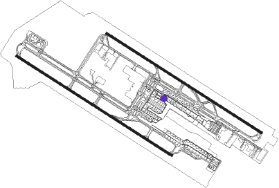
Taxiway locations
Parking locations
|
Nearby beacons
| code | identifier | dist | bearing | frequency |
|---|---|---|---|---|
| SOA | SOACHA (BOGOTA) VOR/DME | 9.7 | 231° | 108.60 |
| BOG | BOGOTA VOR/DME | 13.4 | 309° | 113.90 |
| ZIP | ZIPAQUIRA (BOGOTA) VOR/DME | 21 | 27° | 114.70 |
| ABL | AMBALEMA VOR/DME | 37.4 | 277° | 112.70 |
| TOL | GENERAL GUSTAVO ROJAS PIN VOR/DME | 40 | 228° | 111.20 |
| PY | APIAY NDB | 52.3 | 136° | 250 |
| BUV | BUVIS VOR/DME | 52.5 | 19° | 116.20 |
| GIR | GIRARDOT VOR/DME | 52.9 | 234° | 117.30 |
| MQU | MARIQUITA VOR/DME | 55.1 | 303° | 116.10 |
| AP | APIAY NDB | 55.2 | 133° | 270 |
| PAL | PALANQUERO (PUERTO SALGAR VOR/DME | 56 | 327° | 114.20 |
| VVC | VILLAVICENCIO VOR/DME | 59.7 | 130° | 116.70 |
| IBG | IBAGUE VOR/DME | 60.3 | 252° | 113.10 |
Departure and arrival routes
| Transition altitude | 18000ft |
| Transition level | 19000ft |
| SID end points | distance | outbound heading | |
|---|---|---|---|
| RW13L | |||
| ZIP4H, ZIP2C | 53mi | 19° | |
| DANS1R, OSUS1R | 82mi | 23° | |
| EVRA4B | 34mi | 75° | |
| USID2B | 25mi | 93° | |
| BOGU7A | 60mi | 130° | |
| POVS2U | 46mi | 185° | |
| LIXA1U | 62mi | 215° | |
| KAMI5A | 35mi | 234° | |
| VAPO1R | 95mi | 238° | |
| SILE2E, SILE1A | 31mi | 248° | |
| ISNO1R | 86mi | 261° | |
| ABL2A, ABL6E | 37mi | 277° | |
| VASI1U, TOBK1R | 68mi | 293° | |
| RW13R | |||
| ZIP4H, ZIP2C | 53mi | 19° | |
| DANS1R, OSUS1R | 82mi | 23° | |
| EVRA4B | 34mi | 75° | |
| USID2B | 25mi | 93° | |
| BOGU7A | 60mi | 130° | |
| POVS2U | 46mi | 185° | |
| LIXA1U | 62mi | 215° | |
| KAMI5A | 35mi | 234° | |
| VAPO1R | 95mi | 238° | |
| SILE1A, SILE2E | 31mi | 248° | |
| ISNO1R | 86mi | 261° | |
| ABL6E, ABL2A | 37mi | 277° | |
| TOBK1R, VASI1U | 68mi | 293° | |
| RW31L | |||
| ZIP2B, ZIP3D | 53mi | 19° | |
| OSUS1R, DANS1R | 82mi | 23° | |
| USID2A | 34mi | 75° | |
| USID1C | 25mi | 93° | |
| BOGU2C | 60mi | 130° | |
| POVS2T | 46mi | 185° | |
| LIXA1T | 62mi | 215° | |
| KAMI2C | 35mi | 234° | |
| VAPO1R | 95mi | 238° | |
| SILE2D | 31mi | 248° | |
| ISNO1R | 86mi | 261° | |
| ABL3K | 37mi | 277° | |
| TOBK1R, VASI1T | 68mi | 293° | |
| RW31R | |||
| ZIP2B, ZIP3D | 53mi | 19° | |
| DANS1R, OSUS1R | 82mi | 23° | |
| USID2A | 34mi | 75° | |
| USID1C | 25mi | 93° | |
| BOGU2C | 60mi | 130° | |
| POVS2T | 46mi | 185° | |
| LIXA1T | 62mi | 215° | |
| KAMI2C | 35mi | 234° | |
| VAPO1R | 95mi | 238° | |
| SILE2D | 31mi | 248° | |
| ISNO1R | 86mi | 261° | |
| ABL3K | 37mi | 277° | |
| TOBK1R, VASI1T | 68mi | 293° | |
| STAR starting points | distance | inbound heading | |
|---|---|---|---|
| RW13 (ALL) | |||
| GIR3E | 52.9 | 54° | |
| TOLI3E | 83.1 | 76° | |
| ABL1L | 37.4 | 97° | |
| TIRT3E | 84.4 | 108° | |
| EDPU3E | 71.1 | 119° | |
| ISVA3E | 83.3 | 135° | |
| MUGO2T | 87.2 | 142° | |
| ATAN2T, ATAN3E | 87.7 | 152° | |
| VULA5D | 37.9 | 158° | |
| GRUD2T, GRUD2E | 122.5 | 179° | |
| ILSE3E | 79.1 | 187° | |
| DOPL3E | 79.4 | 211° | |
| ENVA3E | 60.6 | 218° | |
| SIRU3E | 55.1 | 243° | |
| EGEP3E | 40.1 | 314° | |
| RW31 (ALL) | |||
| GIR3W | 52.9 | 54° | |
| TOLI3W | 83.1 | 76° | |
| ABL1M | 37.4 | 97° | |
| TIRT3W | 84.4 | 108° | |
| EDPU3W | 71.1 | 119° | |
| ISVA3W | 83.3 | 135° | |
| MUGO2S | 87.2 | 142° | |
| ATAN2S, ATAN3W | 87.7 | 152° | |
| VULA2F | 37.9 | 158° | |
| GRUD2S, GRUD2W | 122.5 | 179° | |
| ILSE3W | 79.1 | 187° | |
| DOPL3W | 79.4 | 211° | |
| ENVA3W | 60.6 | 218° | |
| SIRU3W, SIRU1S | 55.1 | 243° | |
| EGEP3W, EGEP1S | 40.1 | 314° | |
Instrument approach procedures
| runway | airway (heading) | route (dist, bearing) |
|---|---|---|
| RW31LC | AMVES (128°) | AMVES BO412 (9mi, 153°) 13500ft BO413 (4mi, 153°) 13500ft BO414 (2mi, 141°) 13500ft BO415 (5mi, 129°) 11900ft BO416 (2mi, 116°) 11100ft |
| RNAV | BO416 11100ft BO479 (3mi, 105°) 10400ft BO480 (3mi, 63°) 9900ft BO481 (3mi, 344°) 8980ft SKBO (3mi, 320°) 8406ft BO470 (6mi, 301°) BO471 (3mi, 320°) 10800ft BO472 (5mi, 352°) 12000ft BO473 (11mi, 352°) BO474 (8mi, 280°) BO475 (8mi, 202°) AMVES (6mi, 127°) 13000ft AMVES (turn) 13000ft | |
| RW31LX | AMVES (128°) | AMVES BO710 (18mi, 153°) |
| RNAV | BO710 BO708 (3mi, 153°) 15000ft BO706 (3mi, 153°) BO704 (8mi, 84°) BO702 (2mi, 15°) BO700 (3mi, 341°) SKBO (3mi, 318°) 8406ft BO470 (6mi, 301°) BO471 (3mi, 320°) 10800ft BO472 (5mi, 352°) 12000ft BO473 (11mi, 352°) BO474 (8mi, 280°) BO475 (8mi, 202°) AMVES (6mi, 127°) 13000ft AMVES (turn) 13000ft | |
| RW31LZ | MADLA (341°) | MADLA 16000ft BO719 (2mi, 280°) |
| RNAV | BO719 BO718 (7mi, 307°) 15000ft BO716 (5mi, 354°) BO702 (9mi, 15°) BO700 (3mi, 341°) SKBO (3mi, 318°) 8406ft BO470 (6mi, 301°) BO471 (3mi, 320°) 10800ft BO472 (5mi, 352°) 12000ft BO473 (11mi, 352°) BO474 (8mi, 280°) BO475 (8mi, 202°) AMVES (6mi, 127°) 13000ft AMVES (turn) 13000ft | |
| RW31RC | AMVES (128°) | AMVES BO412 (9mi, 153°) 13500ft BO413 (4mi, 153°) 13500ft BO414 (2mi, 141°) 13500ft BO415 (5mi, 129°) 11800ft BO416 (2mi, 116°) 11000ft |
| RNAV | BO416 11000ft BO419 (3mi, 103°) 10400ft BO482 (3mi, 61°) 9900ft BO423 (3mi, 342°) 8950ft SKBO (3mi, 304°) 8410ft BO503 (5mi, 309°) BO471 (4mi, 307°) 10800ft BO472 (5mi, 352°) 12000ft BO473 (11mi, 352°) BO474 (8mi, 280°) BO475 (8mi, 202°) AMVES (6mi, 127°) 13000ft AMVES (turn) 13000ft | |
| RW31RX | AMVES (128°) | AMVES BO710 (18mi, 153°) |
| RNAV | BO710 BO708 (3mi, 153°) 15000ft BO706 (3mi, 153°) BO704 (8mi, 84°) BO751 (4mi, 15°) 9700ft BO750 (2mi, 341°) SKBO (3mi, 304°) 8410ft BO503 (5mi, 309°) BO471 (4mi, 307°) 10800ft BO472 (5mi, 352°) 12000ft BO473 (11mi, 352°) BO474 (8mi, 280°) BO475 (8mi, 202°) AMVES (6mi, 127°) 13000ft AMVES (turn) 13000ft | |
| RW31RZ | MADLA (341°) | MADLA 16000ft BO719 (2mi, 280°) |
| RNAV | BO719 BO767 (7mi, 307°) 15000ft BO716 (5mi, 354°) BO751 (11mi, 15°) 9700ft BO750 (2mi, 341°) SKBO (3mi, 304°) 8410ft BO503 (5mi, 309°) BO471 (4mi, 307°) 10800ft BO472 (5mi, 352°) 12000ft BO473 (11mi, 352°) BO474 (8mi, 280°) BO475 (8mi, 202°) AMVES (6mi, 127°) 13000ft AMVES (turn) 13000ft |
Holding patterns
| STAR name | hold at | type | turn | heading* | altitude | leg | speed limit |
|---|---|---|---|---|---|---|---|
| ATAN2S | AMVES | VHF | left | 314 (134)° | > 15000ft | 1.5min timed | 250 |
| ATAN2S | PAPET | VHF | left | 56 (236)° | > 18000ft | 1.5min timed | 250 |
| ATAN2T | AMVES | VHF | left | 314 (134)° | > 15000ft | 1.5min timed | 250 |
| ATAN2T | PAPET | VHF | left | 56 (236)° | > 18000ft | 1.5min timed | 250 |
| ATAN3E | AMVES | VHF | left | 314 (134)° | > 15000ft | 1.5min timed | 250 |
| ATAN3E | MQU | NDB | left | 346 (166)° | 10000ft - 19500ft | 1.0min timed | ICAO rules |
| ATAN3W | AMVES | VHF | left | 314 (134)° | > 15000ft | 1.5min timed | 250 |
| ATAN3W | MQU | NDB | left | 346 (166)° | 10000ft - 19500ft | 1.0min timed | ICAO rules |
| DOPL3E | AMVES | VHF | left | 314 (134)° | > 15000ft | 1.5min timed | 250 |
| DOPL3E | PAPET | VHF | left | 56 (236)° | > 18000ft | 1.5min timed | 250 |
| DOPL3W | AMVES | VHF | left | 314 (134)° | > 15000ft | 1.5min timed | 250 |
| DOPL3W | PAPET | VHF | left | 56 (236)° | > 18000ft | 1.5min timed | 250 |
| EDPU3E | AMVES | VHF | left | 314 (134)° | > 15000ft | 1.5min timed | 250 |
| EDPU3E | MQU | NDB | left | 346 (166)° | 10000ft - 19500ft | 1.0min timed | ICAO rules |
| EDPU3W | AMVES | VHF | left | 314 (134)° | > 15000ft | 1.5min timed | 250 |
| EDPU3W | MQU | NDB | left | 346 (166)° | 10000ft - 19500ft | 1.0min timed | ICAO rules |
| EGEP1S | MADLA | VHF | right | 107 (287)° | > 16000ft | 1.5min timed | 230 |
| EGEP3E | AMVES | VHF | left | 314 (134)° | > 15000ft | 1.5min timed | 250 |
| EGEP3E | VUNEX | VHF | left | 115 (295)° | > 18000ft | 1.5min timed | 250 |
| EGEP3W | AMVES | VHF | left | 314 (134)° | > 15000ft | 1.5min timed | 250 |
| EGEP3W | VUNEX | VHF | left | 115 (295)° | > 18000ft | 1.5min timed | 250 |
| ENVA3E | AMVES | VHF | left | 314 (134)° | > 15000ft | 1.5min timed | 250 |
| ENVA3E | PAPET | VHF | left | 56 (236)° | > 18000ft | 1.5min timed | 250 |
| ENVA3W | AMVES | VHF | left | 314 (134)° | > 15000ft | 1.5min timed | 250 |
| ENVA3W | PAPET | VHF | left | 56 (236)° | > 18000ft | 1.5min timed | 250 |
| GIR3E | AMVES | VHF | left | 314 (134)° | > 15000ft | 1.5min timed | 250 |
| GIR3E | IRUPU | VHF | left | 179 (359)° | > 17000ft | 1.5min timed | 250 |
| GIR3W | AMVES | VHF | left | 314 (134)° | > 15000ft | 1.5min timed | 250 |
| GIR3W | IRUPU | VHF | left | 179 (359)° | > 17000ft | 1.5min timed | 250 |
| GRUD2E | AMVES | VHF | left | 314 (134)° | > 15000ft | 1.5min timed | 250 |
| GRUD2E | PAPET | VHF | left | 56 (236)° | > 18000ft | 1.5min timed | 250 |
| GRUD2S | AMVES | VHF | left | 314 (134)° | > 15000ft | 1.5min timed | 250 |
| GRUD2S | PAPET | VHF | left | 56 (236)° | > 18000ft | 1.5min timed | 250 |
| GRUD2T | AMVES | VHF | left | 314 (134)° | > 15000ft | 1.5min timed | 250 |
| GRUD2T | PAPET | VHF | left | 56 (236)° | > 18000ft | 1.5min timed | 250 |
| GRUD2W | AMVES | VHF | left | 314 (134)° | > 15000ft | 1.5min timed | 250 |
| GRUD2W | PAPET | VHF | left | 56 (236)° | > 18000ft | 1.5min timed | 250 |
| ILSE3E | AMVES | VHF | left | 314 (134)° | > 15000ft | 1.5min timed | 250 |
| ILSE3E | PAPET | VHF | left | 56 (236)° | > 18000ft | 1.5min timed | 250 |
| ILSE3W | AMVES | VHF | left | 314 (134)° | > 15000ft | 1.5min timed | 250 |
| ILSE3W | PAPET | VHF | left | 56 (236)° | > 18000ft | 1.5min timed | 250 |
| ISVA3E | AMVES | VHF | left | 314 (134)° | > 15000ft | 1.5min timed | 250 |
| ISVA3E | MQU | NDB | left | 346 (166)° | 10000ft - 19500ft | 1.0min timed | ICAO rules |
| ISVA3W | AMVES | VHF | left | 314 (134)° | > 15000ft | 1.5min timed | 250 |
| ISVA3W | MQU | NDB | left | 346 (166)° | 10000ft - 19500ft | 1.0min timed | ICAO rules |
| MUGO2S | AMVES | VHF | left | 314 (134)° | > 15000ft | 1.5min timed | 250 |
| MUGO2S | PAPET | VHF | left | 56 (236)° | > 18000ft | 1.5min timed | 250 |
| MUGO2T | AMVES | VHF | left | 314 (134)° | > 15000ft | 1.5min timed | 250 |
| MUGO2T | PAPET | VHF | left | 56 (236)° | > 18000ft | 1.5min timed | 250 |
| SIRU1S | OPLEK | VHF | left | 69 (249)° | > 15000ft | 1.5min timed | 250 |
| SIRU3E | AMVES | VHF | left | 314 (134)° | > 15000ft | 1.5min timed | 250 |
| SIRU3E | PAPET | VHF | left | 56 (236)° | > 18000ft | 1.5min timed | 250 |
| SIRU3W | AMVES | VHF | left | 314 (134)° | > 15000ft | 1.5min timed | 250 |
| SIRU3W | PAPET | VHF | left | 56 (236)° | > 18000ft | 1.5min timed | 250 |
| TIRT3E | AMVES | VHF | left | 314 (134)° | > 15000ft | 1.5min timed | 250 |
| TIRT3E | IRUPU | VHF | left | 179 (359)° | > 17000ft | 1.5min timed | 250 |
| TIRT3W | AMVES | VHF | left | 314 (134)° | > 15000ft | 1.5min timed | 250 |
| TIRT3W | IRUPU | VHF | left | 179 (359)° | > 17000ft | 1.5min timed | 250 |
| TOLI3E | AMVES | VHF | left | 314 (134)° | > 15000ft | 1.5min timed | 250 |
| TOLI3E | IRUPU | VHF | left | 179 (359)° | > 17000ft | 1.5min timed | 250 |
| TOLI3W | AMVES | VHF | left | 314 (134)° | > 15000ft | 1.5min timed | 250 |
| TOLI3W | IRUPU | VHF | left | 179 (359)° | > 17000ft | 1.5min timed | 250 |
| VUNE3E | AMVES | VHF | left | 314 (134)° | > 15000ft | 1.5min timed | 250 |
| VUNE3E | VUNEX | VHF | left | 115 (295)° | > 18000ft | 1.5min timed | 250 |
| VUNE3W | AMVES | VHF | left | 314 (134)° | > 15000ft | 1.5min timed | 250 |
| VUNE3W | VUNEX | VHF | left | 115 (295)° | > 18000ft | 1.5min timed | 250 |
| *) magnetic outbound (inbound) holding course | |||||||
Disclaimer
The information on this website is not for real aviation. Use this data with the X-Plane flight simulator only! Data taken with kind consent from X-Plane 12 source code and data files. Content is subject to change without notice.