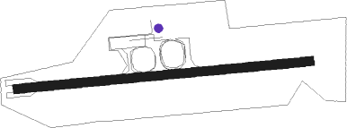
Tak Mae Sot
Airport details
| Country | Thailand |
| State | Tak Province |
| Region | VT |
| Airspace | Bangkok Ctr |
| Municipality | Mae Sot |
| Elevation | 688ft (210m) |
| Timezone | GMT +7 |
| Coordinates | 16.69983, 98.54348 |
| Magnetic var | |
| Type | land |
| Available since | X-Plane v10.40 |
| ICAO code | VTPM |
| IATA code | MAQ |
| FAA code | n/a |
Communication
| Tak Mae Sot Approach | 120.650 |
| Tak Mae Sot Tower | 118.350 |
Nearby beacons
| code | identifier | dist | bearing | frequency |
|---|---|---|---|---|
| MST | MAE SOT (TAK) VOR/DME | 0.1 | 223° | 116.70 |
| MS | MAE SOT (TAK) NDB | 0.2 | 300° | 316 |
| TK | TAK NDB | 42.4 | 74° | 332 |
| PA | HPA-AN NDB | 51.2 | 282° | 365 |
| MM | MAWLAMYINE NDB | 53.2 | 254° | 330 |
Departure and arrival routes
| Transition altitude | 11000ft |
| Transition level | 13000ft |
| SID end points | distance | outbound heading | |
|---|---|---|---|
| RW09 | |||
| LILR1A | 22mi | 11° | |
| ISBE1A, ISBE1B | 21mi | 74° | |
Instrument approach procedures
| runway | airway (heading) | route (dist, bearing) |
|---|---|---|
| RW27 | BEKDU (279°) | BEKDU 7000ft EGUNA (5mi, 313°) 5000ft |
| RW27 | ISBEL (254°) | ISBEL 7000ft EGUNA (7mi, 218°) 5000ft |
| RW27 | LILRI (191°) | LILRI 7000ft DOMPO (12mi, 140°) 5000ft PAVNA (6mi, 140°) 5000ft EGUNA (7mi, 179°) 5000ft |
| RNAV | EGUNA 5000ft MERES (7mi, 269°) 3600ft PM202 (2mi, 269°) 2950ft PM201 (2mi, 269°) 2200ft SURUN (2mi, 269°) 1372ft VETEG (7mi, 350°) EMSIK (5mi, 24°) 4000ft DOMPO (9mi, 89°) 5000ft PAVNA (6mi, 140°) 5000ft EGUNA (7mi, 179°) 5000ft EGUNA (turn) 5000ft |
Disclaimer
The information on this website is not for real aviation. Use this data with the X-Plane flight simulator only! Data taken with kind consent from X-Plane 12 source code and data files. Content is subject to change without notice.
