Tianjin - Tianjin Binhai Intl.
Airport details
| Country | China |
| State | Tianjin |
| Region | ZB |
| Airspace | Beijing Ctr |
| Municipality | Dongli District |
| Elevation | 13ft (4m) |
| Timezone | GMT +8 |
| Coordinates | 39.12333, 117.34500 |
| Magnetic var | |
| Type | land |
| Available since | X-Plane v10.40 |
| ICAO code | ZBTJ |
| IATA code | TSN |
| FAA code | n/a |
Communication
| Tianjin Binhai Intl. ATIS | 126.400 |
| Tianjin Binhai Intl. Tianjin Delivery | 121.800 |
| Tianjin Binhai Intl. Tianjin Ground | 121.950 |
| Tianjin Binhai Intl. Tianjin Tower | 118.200 |
| Tianjin Binhai Intl. Tianjin Tower | 118.875 |
| Tianjin Binhai Intl. Tianjin Approach | 127.900 |
| Tianjin Binhai Intl. Tianjin Approach | 125.250 |
Approach frequencies
| ILS-cat-I | RW34L | 110.5 | 18.00mi |
| ILS-cat-I | RW16L | 109.7 | 18.00mi |
| ILS-cat-I | RW16R | 110.9 | 18.00mi |
| ILS-cat-I | RW34R | 111.5 | 18.00mi |
| 3° GS | RW34L | 110.5 | 18.00mi |
| 3° GS | RW16L | 109.7 | 18.00mi |
| 3° GS | RW16R | 110.9 | 18.00mi |
| 3° GS | RW34R | 111.5 | 18.00mi |
Nearby Points of Interest:
Memorial Hall of the Boxer Uprising
-St. Joseph Cathedral
-Yongding River
Runway info
Runway 16L / 34R  | ||
| length | 3203m (10509ft) | |
| bearing | 148° / 328° | |
| width | 45m (148ft) | |
| surface | concrete | |
| blast zone | 60m (197ft) / 61m (200ft) | |
| Runway 16R / 34L | ||
| length | 3604m (11824ft) | |
| bearing | 148° / 328° | |
| width | 60m (197ft) | |
| surface | asphalt | |
| displ threshold | 400m (1312ft) / 0m (0ft) | |
| blast zone | 60m (197ft) / 60m (197ft) | |
Airport layout
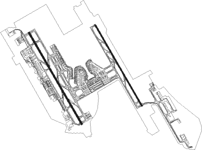
Taxiway locations
|
Parking locations
|
Nearby beacons
| code | identifier | dist | bearing | frequency |
|---|---|---|---|---|
| TAJ | TIANJIN VOR/DME | 0.9 | 135° | 112.10 |
| CG | TIANJIN NDB | 2.9 | 145° | 339 |
| TJK | DONGLIHU VOR/DME | 8.3 | 79° | 113.40 |
| VM | SHIGEZHUANG NDB | 23.1 | 291° | 280 |
| VYK | DAWANGZHUANG VOR/DME | 36.2 | 275° | 112.70 |
| DXG | DAXING VOR/DME | 48.9 | 290° | 115.35 |
| WF | XILIUHETUN NDB | 53.9 | 330° | 395 |
| PEK | GUANZHUANG VOR/DME | 62.3 | 327° | 114.70 |
| QU | BEIJING CAPITAL NDB | 62.3 | 320° | 240 |
| DK | BEIJING CAPITAL NDB | 65.2 | 320° | 354 |
| OR | BEIJING CAPITAL NDB | 69.4 | 323° | 196 |
| SZY | SHAZIYING VOR/DME | 72.6 | 317° | 117.20 |
| CU | SHAHE NDB | 74.9 | 316° | 555 |
Departure and arrival routes
| Transition altitude | 9842ft |
| Transition level | 11811ft |
| SID end points | distance | outbound heading | |
|---|---|---|---|
| RW16L | |||
| MUG6ZD | 32mi | 94° | |
| IGM6ZD | 37mi | 113° | |
| ELK6ZD | 43mi | 235° | |
| OMD6ZD | 65mi | 250° | |
| PEG6ZD | 86mi | 264° | |
| BOT6ZD | 101mi | 295° | |
| IDK6ZD | 106mi | 335° | |
| RW16R | |||
| MUG4ZD | 32mi | 94° | |
| IGM4ZD | 37mi | 113° | |
| ELK4ZD | 43mi | 235° | |
| OMD4ZD | 65mi | 250° | |
| PEG4ZD | 86mi | 264° | |
| BOT4ZD | 101mi | 295° | |
| IDK4ZD | 106mi | 335° | |
| RW34L | |||
| MUG5ZD, MUG5YD | 32mi | 94° | |
| IGM5ZD, IGM5YD | 37mi | 113° | |
| ELK5YD, ELK5ZD, ELK5TD | 43mi | 235° | |
| OMD5TD, OMD5YD, OMD5ZD | 65mi | 250° | |
| PEG5TD, PEG5ZD, PEG5YD | 86mi | 264° | |
| BOT5ZD, BOT5TD, BOT5YD | 101mi | 295° | |
| IDK5ZD, IDK5YD, IDK5TD | 106mi | 335° | |
| RW34R | |||
| MUG7YD, MUG7ZD | 32mi | 94° | |
| IGM7ZD, IGM7YD | 37mi | 113° | |
| ELK7YD, ELK7ZD, ELK7TD | 43mi | 235° | |
| OMD7ZD, OMD7TD, OMD7YD | 65mi | 250° | |
| PEG7TD, PEG7ZD, PEG7YD | 86mi | 264° | |
| BOT7YD, BOT7TD, BOT7ZD | 101mi | 295° | |
| IDK7ZD, IDK7YD, IDK7TD | 106mi | 335° | |
| STAR starting points | distance | inbound heading | |
|---|---|---|---|
| RW16 (ALL) | |||
| AVB4ZA, AVB6ZA | 53.4 | 64° | |
| GUV6ZA, GUV6YA, GUV4ZA, GUV4YA | 114.9 | 126° | |
| DUM6ZA, DUM6YA, DUM4ZA | 45.2 | 308° | |
| RW34L | |||
| AVB5ZA | 53.4 | 64° | |
| GUV5YA, GUV5ZA | 114.9 | 126° | |
| DUM5ZA | 45.2 | 308° | |
| RW34R | |||
| AVB7ZA | 53.4 | 64° | |
| GUV7ZA, GUV7YA | 114.9 | 126° | |
| DUM7ZA | 45.2 | 308° | |
Holding patterns
| STAR name | hold at | type | turn | heading* | altitude | leg | speed limit |
|---|---|---|---|---|---|---|---|
| DUM4ZA | TJ944 | VHF | right | 115 (295)° | > 3940ft | DME 5.4mi | ICAO rules |
| DUM5ZA | TJ841 | VHF | right | 124 (304)° | > 3940ft | DME 5.4mi | ICAO rules |
| DUM6YA | TJ944 | VHF | right | 115 (295)° | > 3940ft | DME 5.4mi | ICAO rules |
| DUM7ZA | TJ841 | VHF | right | 124 (304)° | > 3940ft | DME 5.4mi | ICAO rules |
| GUV4YA | TJ944 | VHF | right | 115 (295)° | > 3940ft | DME 5.4mi | ICAO rules |
| GUV5YA | TJ841 | VHF | right | 124 (304)° | > 3940ft | DME 5.4mi | ICAO rules |
| GUV6YA | TJ944 | VHF | right | 115 (295)° | > 3940ft | DME 5.4mi | ICAO rules |
| GUV7YA | TJ841 | VHF | right | 124 (304)° | > 3940ft | DME 5.4mi | ICAO rules |
| *) magnetic outbound (inbound) holding course | |||||||
Disclaimer
The information on this website is not for real aviation. Use this data with the X-Plane flight simulator only! Data taken with kind consent from X-Plane 12 source code and data files. Content is subject to change without notice.