Chengdu - Chengdu Shuangliu Intl
Airport details
| Country | China |
| State | Sichuan |
| Region | ZP |
| Airspace | Kunming Ctr |
| Municipality | Chengdu City |
| Elevation | 1627ft (496m) |
| Timezone | GMT +8 |
| Coordinates | 30.57833, 103.94666 |
| Magnetic var | |
| Type | land |
| Available since | X-Plane v10.40 |
| ICAO code | ZUUU |
| IATA code | CTU |
| FAA code | n/a |
Communication
| Chengdu Shuangliu Intl ATIS - Arrival | 126.450 |
| Chengdu Shuangliu Intl ATIS - Departure | 128.600 |
| Chengdu Shuangliu Intl CHENGDU DELIVERY | 121.600 |
| Chengdu Shuangliu Intl CHENGDU Ground Control 02R/20L | 121.750 |
| Chengdu Shuangliu Intl CHENGDU Ground Control 02L/20R | 121.850 |
| Chengdu Shuangliu Intl CHENGDU Tower 02R/20L | 130.350 |
| Chengdu Shuangliu Intl CHENGDU Tower 02L/20R | 123.000 |
| Chengdu Shuangliu Intl CHENGDU Approach AREA 3 | 119.250 |
| Chengdu Shuangliu Intl CHENGDU Approach AREA 4 | 124.750 |
| Chengdu Shuangliu Intl CHENGDU Approach AREA 1 | 124.850 |
| Chengdu Shuangliu Intl CHENGDU Approach AREA 5 | 119.425 |
| Chengdu Shuangliu Intl CHENGDU Approach AREA 2 | 119.700 |
Approach frequencies
| ILS-cat-II | RW02R | 108.7 | 18.00mi |
| ILS-cat-II | RW02L | 111.1 | 18.00mi |
| ILS-cat-I | RW20R | 109.1 | 18.00mi |
| ILS-cat-I | RW20L | 109.7 | 18.00mi |
| 3° GS | RW20R | 109.1 | 18.00mi |
| 3° GS | RW02R | 108.7 | 18.00mi |
| 3° GS | RW20L | 109.7 | 18.00mi |
| 3° GS | RW02L | 111.1 | 18.00mi |
Nearby Points of Interest:
Monument to the Martyrs of the Railway Protection Movement
-Wenshu Monastery
-Zhaojue Temple
-Qingchengshan-Dujiangyan National Park
-Dujiangyan
Runway info
Runway 02L / 20R  | ||
| length | 3614m (11857ft) | |
| bearing | 25° / 205° | |
| width | 45m (148ft) | |
| surface | asphalt | |
| blast zone | 61m (200ft) / 61m (200ft) | |
| Runway 02R / 20L | ||
| length | 3614m (11857ft) | |
| bearing | 25° / 205° | |
| width | 60m (197ft) | |
| surface | concrete | |
| blast zone | 122m (400ft) / 122m (400ft) | |
Airport layout
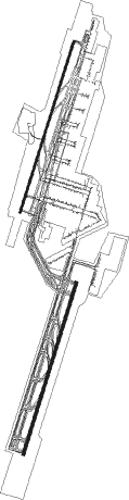
Taxiway locations
|
Parking locations
Nearby beacons
| code | identifier | dist | bearing | frequency |
|---|---|---|---|---|
| CTU | SHUANGLIU VOR/DME | 0.3 | 214° | 115.70 |
| Z | SHUANGLIU (CHENGDU) NDB | 1.5 | 205° | 396 |
| ZW | CHENGDU NDB | 5.1 | 206° | 260 |
| BHS | BAIHESI VOR/DME | 13.7 | 105° | 117.90 |
| CZH | CHONGZHOU VOR/DME | 14 | 284° | 114.50 |
| HLC | HUILONG VOR/DME | 21.1 | 222° | 115.95 |
| WFX | WUFENGXI VOR/DME | 28.2 | 87° | 117.10 |
| JTG | JINTANG VOR/DME | 28.8 | 57° | 115.40 |
| ZGA | ZHUGAO VOR/DME | 40.5 | 89° | 115.25 |
| CDX | DEXIN VOR/DME | 46.1 | 33° | 116.35 |
| JYA | JINGYAN VOR/DME | 48.6 | 173° | 114.65 |
| ZYG | ZIYANG VOR/DME | 56.1 | 129° | 112.10 |
| MYG | MIANYANG VOR/DME | 65.3 | 43° | 114.80 |
Departure and arrival routes
| Transition altitude | 9800ft |
| Transition level | 11800ft |
| SID end points | distance | outbound heading | |
|---|---|---|---|
| RW02L | |||
| BOK01D, BOKI8T, BOKI9W | 74mi | 19° | |
| GURE9W, GURE8T, GUR01D | 83mi | 65° | |
| UBRA9W, UBR01D | 78mi | 80° | |
| IDB01D, IDBO9W | 88mi | 144° | |
| LUV01D, LUVE9W | 72mi | 176° | |
| MUM01D, MUMG9W, MUMG8T, MUM02D | 50mi | 284° | |
| RW02R | |||
| BOKI9X, BOK21D | 74mi | 19° | |
| GUR21D, GURE9X | 83mi | 65° | |
| UBRA9X, UBR21D | 78mi | 80° | |
| IDB21D, IDBO9X | 88mi | 144° | |
| LUVE9X, LUV21D | 72mi | 176° | |
| MUM21D, MUMG9X | 50mi | 284° | |
| RW20L | |||
| BOKI9Y, BOK31D | 74mi | 19° | |
| GUR31D, GURE9Y | 83mi | 65° | |
| UBRA9Y, UBR31D | 78mi | 80° | |
| IDB31D, IDBO9Y | 88mi | 144° | |
| LUVE9Y, LUV31D | 72mi | 176° | |
| MUM31D, MUMG9Y | 50mi | 284° | |
| RW20R | |||
| BOKI9Z, BOK11D | 74mi | 19° | |
| GUR11D, GURE9Z | 83mi | 65° | |
| UBR11D, UBRA9Z | 78mi | 80° | |
| IDBO9Z, IDB11D | 88mi | 144° | |
| LUVE9Z, LUV11D | 72mi | 176° | |
| MUM11D, MUMG9Z | 50mi | 284° | |
| STAR starting points | distance | inbound heading | |
|---|---|---|---|
| RW02 (ALL) | |||
| LADU9J, LAD01A | 48.1 | 92° | |
| MEXA8J, MEXA6J, MEX02A | 80.4 | 210° | |
| AKD02A, AKDI8J, AKDI6J | 92.8 | 229° | |
| EKOK8J, EKOK6J | 73.4 | 267° | |
| RW02L | |||
| MEX01A, EKO01A, AKD01A | 14.8 | 333° | |
| IGN01A | 48.6 | 353° | |
| AKDI9J, EKOK9J, IGNA9J, MEXA9J | 16.3 | 357° | |
| RW02R | |||
| MEX01A, EKO01A, AKD01A | 14.8 | 333° | |
| IGN01A | 48.6 | 353° | |
| AKDI9J, MEXA9J, IGNA9J, EKOK9J | 16.3 | 357° | |
| RW20 (ALL) | |||
| LAD11A | 48.1 | 92° | |
| MEXA9L, MEX12A, MEX11A | 80.4 | 210° | |
| AKDI9L, AKD12A, AKD11A | 92.8 | 229° | |
| EKOK9L, EKO11A | 73.4 | 267° | |
| IGN11A | 80.1 | 346° | |
| RW20L | |||
| MEXA6L, LADU9L, IGNA9L, AKDI6L | 10.5 | 166° | |
| RW20R | |||
| MEXA6L, LADU9L, IGNA9L, AKDI6L | 10.5 | 166° | |
Holding patterns
| STAR name | hold at | type | turn | heading* | altitude | leg | speed limit |
|---|---|---|---|---|---|---|---|
| AKD01A | BHS | NDB | left | 82 (262)° | > 4930ft | 1.0min timed | ICAO rules |
| AKD01A | WFX30 | VHF | left | 16 (196)° | > 11800ft | 1.0min timed | ICAO rules |
| AKD11A | D029P | VHF | right | 29 (209)° | > 7880ft | 1.0min timed | ICAO rules |
| AKDI6J | UU802 | VHF | left | 33 (213)° | > 9850ft | 1.0min timed | ICAO rules |
| AKDI6L | UU935 | VHF | right | 65 (245)° | > 9850ft | 1.0min timed | ICAO rules |
| AKDI8J | UU910 | VHF | right | 24 (204)° | > 8860ft | 1.0min timed | ICAO rules |
| AKDI9J | UU802 | VHF | left | 33 (213)° | > 9850ft | 1.0min timed | ICAO rules |
| AKDI9L | UU821 | VHF | right | 24 (204)° | > 9850ft | 1.0min timed | ICAO rules |
| EKO01A | BHS | NDB | left | 82 (262)° | > 4930ft | 1.0min timed | ICAO rules |
| IGN11A | D204N | VHF | left | 131 (311)° | > 8860ft | 1.0min timed | ICAO rules |
| IGN11A | HLC | NDB | right | 204 (24)° | > 7880ft | 1.0min timed | ICAO rules |
| IGNA9J | UU718 | VHF | left | 147 (327)° | > 8860ft | 1.0min timed | ICAO rules |
| IGNA9L | HLC | NDB | right | 204 (24)° | > 7880ft | 1.0min timed | ICAO rules |
| IGNA9L | UU718 | VHF | left | 147 (327)° | > 8860ft | 1.0min timed | ICAO rules |
| LAD01A | CZH | NDB | left | 278 (98)° | > 12800ft | 1.0min timed | ICAO rules |
| LAD11A | CZH | NDB | left | 278 (98)° | > 12800ft | 1.0min timed | ICAO rules |
| LADU9J | CZH | NDB | left | 278 (98)° | > 12800ft | 1.0min timed | ICAO rules |
| LADU9L | CZH | NDB | left | 278 (98)° | > 12800ft | 1.0min timed | ICAO rules |
| MEX01A | BHS | NDB | left | 82 (262)° | > 4930ft | 1.0min timed | ICAO rules |
| MEX01A | WFX30 | VHF | left | 16 (196)° | > 11800ft | 1.0min timed | ICAO rules |
| MEX11A | D029P | VHF | right | 29 (209)° | > 7880ft | 1.0min timed | ICAO rules |
| MEXA6J | UU802 | VHF | left | 33 (213)° | > 9850ft | 1.0min timed | ICAO rules |
| MEXA6L | UU935 | VHF | right | 65 (245)° | > 9850ft | 1.0min timed | ICAO rules |
| MEXA8J | UU910 | VHF | right | 24 (204)° | > 8860ft | 1.0min timed | ICAO rules |
| MEXA9J | UU802 | VHF | left | 33 (213)° | > 9850ft | 1.0min timed | ICAO rules |
| MEXA9L | UU821 | VHF | right | 24 (204)° | > 9850ft | 1.0min timed | ICAO rules |
| *) magnetic outbound (inbound) holding course | |||||||
Disclaimer
The information on this website is not for real aviation. Use this data with the X-Plane flight simulator only! Data taken with kind consent from X-Plane 12 source code and data files. Content is subject to change without notice.