Frankfurt-am-main - Frankfurt Am Main
Airport details
| Country | Germany |
| State | Hesse |
| Region | ED |
| Airspace | Langen Ctr |
| Municipality | Frankfurt |
| Elevation | 354ft (108m) |
| Timezone | GMT +1 |
| Coordinates | 50.03331, 8.57046 |
| Magnetic var | |
| Type | land |
| Available since | X-Plane v10.40 |
| ICAO code | EDDF |
| IATA code | FRA |
| FAA code | n/a |
Communication
| Frankfurt am Main ATIS 1 | 118.030 |
| Frankfurt am Main ATIS 2 | 118.730 |
| Frankfurt am Main Delivery | 121.905 |
| Frankfurt am Main Ground | 121.805 |
| Frankfurt am Main Apron South | 121.855 |
| Frankfurt am Main Apron East | 121.955 |
| Frankfurt am Main Apron West | 121.705 |
| Frankfurt am Main Tower 18 | 124.855 |
| Frankfurt am Main Tower 25R/07L | 136.500 |
| Frankfurt am Main Tower 25C/07C | 118.780 |
| Frankfurt am Main Tower 25L/07R | 119.905 |
| Frankfurt am Main Langen Radar | 120.805 |
| Frankfurt am Main Langen Radar | 125.355 |
| Frankfurt am Main Langen Radar | 120.155 |
| Frankfurt am Main Langen Radar | 136.130 |
Approach frequencies
| ILS-cat-III | RW25L | 111.15 | 18.00mi |
| ILS-cat-III | RW07R | 110.95 | 18.00mi |
| ILS-cat-III | RW25R | 111.35 | 18.00mi |
| ILS-cat-III | RW07L | 110.3 | 18.00mi |
| ILS-cat-III | RW25C | 111.55 | 18.00mi |
| ILS-cat-III | RW07C | 110.55 | 18.00mi |
| 3.2° GS | RW07L | 110.3 | 18.00mi |
| 3° GS | RW25L | 111.15 | 18.00mi |
| 3° GS | RW07C | 110.55 | 18.00mi |
| 3° GS | RW25C | 111.55 | 18.00mi |
| 3° GS | RW07R | 110.95 | 18.00mi |
| 3° GS | RW25R | 111.35 | 18.00mi |
Nearby Points of Interest:
Wasserwerk Hinkelstein
-Rohsee
-Wasserburg Goldstein
-Falltorweg 2
-Falltorweg 4
-Falltorweg 6/8
-Zaunweg 21
-Zaunweg 8
-Ernst-Ludwig-Allee 6 (Buchschlag)
-Ernst-Ludwig-Allee 8 (Buchschlag)
-Ernst-Ludwig-Allee 10
-Falltorweg 7
-Zaunweg 5
-Eddersheim barrage and locks
-Zaunweg 3
-Ernst-Ludwig-Allee 11 (Buchschlag)
-Ernst-Ludwig-Allee 13
-Ernst-Ludwig-Allee 17/19
-Ernst-Ludwig-Allee 23
-St.-Josefs-Kirche, Frankfurt-Höchst
-Amtsgericht Höchst
-Kirche Zeilsheim
-Kolonie
-Fritz-Kissel-Siedlung
-Fachwerkhaus
Runway info
Runway 07C / 25C  | ||
| length | 3990m (13091ft) | |
| bearing | 77° / 257° | |
| width | 60m (197ft) | |
| surface | asphalt | |
| blast zone | 70m (230ft) / 255m (837ft) | |
| Runway 07L / 25R | ||
| length | 2793m (9163ft) | |
| bearing | 77° / 257° | |
| width | 45m (148ft) | |
| surface | concrete | |
| blast zone | 31m (102ft) / 32m (105ft) | |
| Runway 07R / 25L | ||
| length | 3991m (13094ft) | |
| bearing | 77° / 257° | |
| width | 45m (148ft) | |
| surface | asphalt | |
| blast zone | 70m (230ft) / 255m (837ft) | |
| Runway 18 / 36 | ||
| length | 3968m (13018ft) | |
| bearing | 179° / 359° | |
| width | 45m (148ft) | |
| surface | asphalt | |
Airport layout - parking location E2A
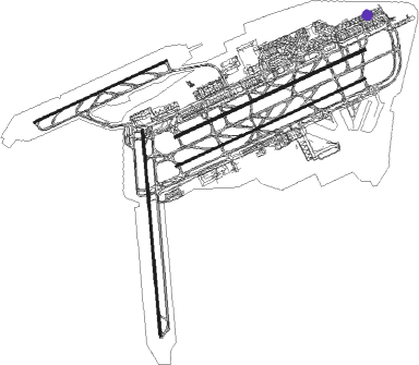
Taxiway locations
|
Parking locations
|
Nearby beacons
| code | identifier | dist | bearing | frequency |
|---|---|---|---|---|
| FRD | DME | 0.2 | 213° | 115.90 |
| FFM | FRANKFURT VORTAC | 2.8 | 73° | 114.20 |
| FR | FRANKFURT NDB | 4.7 | 74° | 297 |
| FW | FRANKFURT NDB | 5.6 | 259° | 382 |
| VFM | NAUHEIM VOR | 5.7 | 234° | 113.75 |
| WIB | WIESBADEN TACAN | 10 | 273° | 114.10 |
| RID | RIED VOR/DME | 15.1 | 187° | 112.20 |
| MTR | METRO VOR | 18 | 49° | 110 |
| CHA | CHARLIE VOR/DME | 19.3 | 103° | 115.35 |
| TAU | TAUNUS VOR/DME | 20.4 | 298° | 113.35 |
| MND | DME | 33.8 | 186° | 113.55 |
| GED | GEDERN VORTAC | 34.6 | 61° | 110.80 |
| SIL | SIEGERLAND NDB | 42.2 | 326° | 489 |
| NKR | NECKAR NDB | 42.3 | 167° | 292 |
| SLD | DME | 44.6 | 324° | 108.05 |
| RMS | RAMSTEIN TACAN | 52.4 | 239° | 113.40 |
| COL | COLA VOR/DME | 58.5 | 308° | 108.80 |
Departure and arrival routes
| Transition altitude | 5000ft |
| Transition level | 60ft |
| SID end points | distance | outbound heading | |
|---|---|---|---|
| RW07C | |||
| MARU5E, MARU9D | 47mi | 7° | |
| TOBA9D | 33mi | 22° | |
| MTR5C | 18mi | 49° | |
| SULU1D | 83mi | 89° | |
| KOMI3D | 65mi | 89° | |
| CIND1X, CIND1D | 29mi | 115° | |
| ANEK4E, ANEK1X, ANEK2D | 43mi | 187° | |
| RID8C | 15mi | 187° | |
| SOBR6E, SOBR6D, SOBR1X | 32mi | 258° | |
| OBOK1E, OBOK1D | 64mi | 300° | |
| RW07R | |||
| MARU9D, MARU5E | 47mi | 7° | |
| TOBA9D | 33mi | 22° | |
| MTR5C | 18mi | 49° | |
| KOMI3D | 65mi | 89° | |
| SULU1D | 83mi | 89° | |
| CIND1Y, CIND1D | 29mi | 115° | |
| ANEK4E, ANEK2D, ANEK1Y | 43mi | 187° | |
| RID8C | 15mi | 187° | |
| SOBR6E, SOBR6D, SOBR1Y | 32mi | 258° | |
| OBOK1E, OBOK1D | 64mi | 300° | |
| RW18 | |||
| MARU7S, MARU5T, MARU3R | 47mi | 7° | |
| TOBA9S, TOBA7T, TOBA3R | 33mi | 22° | |
| SULU1L, SULU3S, SULU3A | 83mi | 89° | |
| CIND2L, CIND4S, CIND2A | 29mi | 115° | |
| ANEK3A, ANEK1L | 43mi | 187° | |
| SOBR1L, SOBR1U | 32mi | 258° | |
| ULKI2S, ULKI1L | 34mi | 259° | |
| OBOK2T, OBOK1L, OBOK1R, OBOK3S | 64mi | 300° | |
| RW25C | |||
| MARU9N, MARU9G, MARU7M, MARU6F, MARU3W | 47mi | 7° | |
| TOBA1G, TOBA2N, TOBA3W, TOBA7F, TOBA7M | 33mi | 22° | |
| SULU2F | 83mi | 89° | |
| CIND2F | 29mi | 115° | |
| ANEK1F | 43mi | 187° | |
| RID3Q | 15mi | 187° | |
| SOBR7N, SOBR7F, SOBR6P | 32mi | 258° | |
| TAU2Q | 20mi | 298° | |
| OBOK2G, OBOK2M, OBOK3W, OBOK4N | 64mi | 300° | |
| RW25L | |||
| MARU9N, MARU9G, MARU6F, MARU5H, MARU3K | 47mi | 7° | |
| TOBA7F, TOBA1G, TOBA2N, TOBA3K, TOBA5H | 33mi | 22° | |
| SULU2F | 83mi | 89° | |
| CIND2F | 29mi | 115° | |
| ANEK1F | 43mi | 187° | |
| RID3Q | 15mi | 187° | |
| SOBR7N, SOBR7F, SOBR6P | 32mi | 258° | |
| TAU2Q | 20mi | 298° | |
| OBOK4N, OBOK3K, OBOK2H, OBOK2G | 64mi | 300° | |
| STAR starting points | distance | inbound heading | |
|---|---|---|---|
| RW07 (ALL) | |||
| UNOK3D, UNOK3C | 57.4 | 107° | |
| ROLI3C, ROLI3D | 37.4 | 118° | |
| KERA3C, KERA3D | 47.0 | 246° | |
| SPES3D, SPES3C | 31.7 | 282° | |
| PETI3D, PETI3C | 94.5 | 288° | |
| FAWU2D, FAWU2C | 79.3 | 289° | |
| EMPA3C, EMPA3D | 95.8 | 345° | |
| RW07C | |||
| UNOK4R | 29.7 | 89° | |
| KERA3R, ROLI3R | 21.8 | 94° | |
| ROLI3H | 20.4 | 118° | |
| SPES2R | 12.4 | 332° | |
| RW07R | |||
| UNOK4R | 29.7 | 89° | |
| KERA3R, ROLI3R | 21.8 | 94° | |
| ROLI3H | 20.4 | 118° | |
| SPES2R | 12.4 | 332° | |
| RW25 (ALL) | |||
| UNOK3A, UNOK3B | 57.4 | 107° | |
| ROLI3B, ROLI3A | 37.4 | 118° | |
| KERA3A, KERA3B | 47.0 | 246° | |
| SPES3B, SPES3A | 31.7 | 282° | |
| PETI3A, PETI3B | 94.5 | 288° | |
| FAWU2B, FAWU2A | 79.3 | 289° | |
| EMPA3B, EMPA3A | 95.8 | 345° | |
| RW25C | |||
| UNOK4G, ROLI4G, KERA2G | 18.0 | 229° | |
| KERA1S | 47.0 | 246° | |
| SPES1G, SPES1S | 31.7 | 282° | |
| RW25L | |||
| UNOK4G, ROLI4G, KERA2G | 18.0 | 229° | |
| KERA1S | 47.0 | 246° | |
| SPES1G, SPES1S | 31.7 | 282° | |
Instrument approach procedures
| runway | airway (heading) | route (dist, bearing) |
|---|---|---|
| RW07CY | IBLUS (74°) | IBLUS 5000ft DF911 (6mi, 78°) 3500ft DF920 (4mi, 78°) 2400ft TIXAK (4mi, 52°) 2000ft |
| RW07CY | ULNOK (39°) | ULNOK 4000ft DF914 (3mi, 300°) 3400ft DF920 (5mi, 344°) 2400ft TIXAK (4mi, 52°) 2000ft |
| RNAV | TIXAK 2000ft EDDF (6mi, 79°) 379ft FR (5mi, 74°) DF273 (5mi, 78°) (3042mi, 190°) 5000ft TAU (3047mi, 9°) 5000ft | |
| RW07CZ | DF554 (77°) | DF554 4000ft DF553 (4mi, 76°) DF552 (4mi, 76°) DF272 (5mi, 76°) 4000ft LOMPO (3mi, 77°) 4000ft |
| RW07CZ | RID (7°) | RID 5000ft DF271 (13mi, 286°) 4000ft DF272 (5mi, 332°) 4000ft LOMPO (3mi, 77°) 4000ft |
| RW07CZ | TAU (118°) | TAU 5000ft DF270 (13mi, 185°) 5000ft DF272 (5mi, 152°) 4000ft LOMPO (3mi, 77°) 4000ft |
| RNAV | LOMPO 4000ft EDDF (13mi, 78°) 379ft FR (5mi, 74°) DF273 (5mi, 78°) (3042mi, 190°) 5000ft TAU (3047mi, 9°) 5000ft | |
| RW07RY | IBLUS (74°) | IBLUS 5000ft DF911 (6mi, 78°) 3500ft DF910 (4mi, 78°) 2400ft BOGVO (3mi, 52°) 2000ft |
| RW07RY | ULNOK (39°) | ULNOK 4000ft DF914 (3mi, 300°) 3400ft DF910 (5mi, 349°) 2400ft BOGVO (3mi, 52°) 2000ft |
| RNAV | BOGVO 2000ft EDDF (7mi, 78°) 378ft FFM (3mi, 73°) DF278 (8mi, 89°) (3040mi, 190°) 5000ft RID (3022mi, 10°) 5000ft | |
| RW07RZ | DF654 (77°) | DF654 4000ft DF653 (4mi, 76°) DF652 (4mi, 76°) DF277 (5mi, 76°) 4000ft ROBSA (3mi, 77°) 4000ft |
| RW07RZ | RID (7°) | RID 5000ft DF276 (13mi, 285°) 4000ft DF277 (5mi, 332°) 4000ft ROBSA (3mi, 77°) 4000ft |
| RW07RZ | TAU (118°) | TAU 5000ft DF275 (14mi, 184°) 5000ft DF277 (5mi, 152°) 4000ft ROBSA (3mi, 77°) 4000ft |
| RNAV | ROBSA 4000ft EDDF (13mi, 77°) 378ft FFM (3mi, 73°) DF278 (8mi, 89°) (3040mi, 190°) 5000ft RID (3022mi, 10°) 5000ft | |
| RW25CY | KUGUK (278°) | KUGUK 5000ft DF907 (4mi, 311°) 4200ft DF901 (5mi, 296°) 3000ft RATRU (6mi, 275°) 2000ft |
| RW25CY | ORVIV (251°) | ORVIV 5000ft DF902 (6mi, 197°) 3900ft DF901 (5mi, 258°) 3000ft RATRU (6mi, 275°) 2000ft |
| RNAV | RATRU 2000ft EDDF (6mi, 254°) 414ft FW (6mi, 259°) DF282 (3mi, 256°) (3032mi, 189°) 5000ft TAU (3047mi, 9°) MTR (26mi, 88°) 5000ft | |
| RW25CZ | CHA (283°) | CHA 5000ft DF281 (13mi, 332°) 4000ft REDGO (3mi, 257°) 4000ft |
| RW25CZ | DF526 (256°) | DF526 4000ft DF525 (4mi, 257°) DF524 (4mi, 257°) DF523 (4mi, 257°) DF522 (4mi, 257°) DF281 (4mi, 257°) 4000ft REDGO (3mi, 257°) 4000ft |
| RW25CZ | MTR (229°) | MTR 5000ft DF281 (10mi, 152°) 4000ft REDGO (3mi, 257°) 4000ft |
| RNAV | REDGO 4000ft EDDF (12mi, 255°) 414ft FW (6mi, 259°) DF282 (3mi, 256°) (3032mi, 189°) 5000ft TAU (3047mi, 9°) 5000ft MTR (26mi, 88°) 5000ft | |
| RW25LY | KUGUK (278°) | KUGUK 5000ft DF907 (4mi, 311°) 4200ft DF901 (5mi, 296°) 3000ft TITUT (6mi, 273°) 2000ft |
| RW25LY | ORVIV (251°) | ORVIV 5000ft DF902 (6mi, 197°) 3900ft DF901 (5mi, 258°) 3000ft TITUT (6mi, 273°) 2000ft |
| RNAV | TITUT 2000ft EDDF (6mi, 255°) 412ft DF290 (3mi, 259°) DF291 (3mi, 245°) (3034mi, 190°) 5000ft CHA (3034mi, 10°) 5000ft | |
| RW25LZ | CHA (283°) | CHA 5000ft DF289 (13mi, 332°) 4000ft LEDKI (3mi, 257°) 4000ft |
| RW25LZ | DF626 (257°) | DF626 4000ft DF625 (4mi, 257°) DF624 (4mi, 257°) DF623 (4mi, 257°) DF622 (4mi, 257°) DF289 (4mi, 257°) 4000ft LEDKI (3mi, 257°) 4000ft |
| RW25LZ | MTR (229°) | MTR 5000ft DF289 (10mi, 152°) 4000ft LEDKI (3mi, 257°) 4000ft |
| RNAV | LEDKI 4000ft EDDF (12mi, 256°) 412ft DF290 (3mi, 259°) DF291 (3mi, 245°) (3034mi, 190°) 5000ft CHA (3034mi, 10°) 5000ft |
Holding patterns
| STAR name | hold at | type | turn | heading* | altitude | leg | speed limit |
|---|---|---|---|---|---|---|---|
| EMPA3A | SPESA | VHF | right | 103 (283)° | > 5000ft | 1.0min timed | 230 |
| EMPA3B | CHA | NDB | right | 103 (283)° | 4000ft - 10000ft | 1.0min timed | 230 |
| EMPA3B | SPESA | VHF | right | 103 (283)° | > 5000ft | 1.0min timed | 230 |
| EMPA3C | CHA | NDB | right | 103 (283)° | 4000ft - 10000ft | 1.0min timed | 230 |
| EMPA3C | SPESA | VHF | right | 103 (283)° | > 5000ft | 1.0min timed | 230 |
| EMPA3D | SPESA | VHF | right | 103 (283)° | > 5000ft | 1.0min timed | 230 |
| FAWU2A | BOWEK | VHF | right | 122 (302)° | > 14000ft | 1.0min timed | 230 |
| FAWU2A | SPESA | VHF | right | 103 (283)° | > 5000ft | 1.0min timed | 230 |
| FAWU2B | BOWEK | VHF | right | 122 (302)° | > 14000ft | 1.0min timed | 230 |
| FAWU2B | CHA | NDB | right | 103 (283)° | 4000ft - 10000ft | 1.0min timed | 230 |
| FAWU2B | SPESA | VHF | right | 103 (283)° | > 5000ft | 1.0min timed | 230 |
| FAWU2C | BOWEK | VHF | right | 122 (302)° | > 14000ft | 1.0min timed | 230 |
| FAWU2C | CHA | NDB | right | 103 (283)° | 4000ft - 10000ft | 1.0min timed | 230 |
| FAWU2C | SPESA | VHF | right | 103 (283)° | > 5000ft | 1.0min timed | 230 |
| FAWU2D | BOWEK | VHF | right | 122 (302)° | > 14000ft | 1.0min timed | 230 |
| FAWU2D | SPESA | VHF | right | 103 (283)° | > 5000ft | 1.0min timed | 230 |
| KERA1S | CHA | NDB | right | 103 (283)° | 4000ft - 10000ft | 1.0min timed | 230 |
| KERA1S | KERAX | VHF | right | 16 (196)° | > 6000ft | 1.0min timed | 230 |
| KERA2G | GED | NDB | right | 359 (179)° | > 6000ft | 1.0min timed | 230 |
| KERA2G | KERAX | VHF | right | 16 (196)° | > 6000ft | 1.0min timed | 230 |
| KERA3A | GED | NDB | right | 359 (179)° | > 6000ft | 1.0min timed | 230 |
| KERA3A | KERAX | VHF | right | 16 (196)° | > 6000ft | 1.0min timed | 230 |
| KERA3B | CHA | NDB | right | 103 (283)° | 4000ft - 10000ft | 1.0min timed | 230 |
| KERA3B | KERAX | VHF | right | 16 (196)° | > 6000ft | 1.0min timed | 230 |
| KERA3C | CHA | NDB | right | 103 (283)° | 4000ft - 10000ft | 1.0min timed | 230 |
| KERA3C | KERAX | VHF | right | 16 (196)° | > 6000ft | 1.0min timed | 230 |
| KERA3C | SPESA | VHF | right | 103 (283)° | > 5000ft | 1.0min timed | 230 |
| KERA3D | GED | NDB | right | 359 (179)° | > 6000ft | 1.0min timed | 230 |
| KERA3D | KERAX | VHF | right | 16 (196)° | > 6000ft | 1.0min timed | 230 |
| KERA3R | GED | NDB | right | 359 (179)° | > 6000ft | 1.0min timed | 230 |
| KERA3R | KERAX | VHF | right | 16 (196)° | > 6000ft | 1.0min timed | 230 |
| KERA6H | KERAX | VHF | right | 16 (196)° | > 6000ft | 1.0min timed | 230 |
| KERA6H | RID | NDB | right | 64 (244)° | > 4000ft | 1.0min timed | ICAO rules |
| PETI3A | REKDI | VHF | right | 145 (325)° | 14000ft - 24000ft | 1.5min timed | ICAO rules |
| PETI3A | SPESA | VHF | right | 103 (283)° | > 5000ft | 1.0min timed | 230 |
| PETI3B | CHA | NDB | right | 103 (283)° | 4000ft - 10000ft | 1.0min timed | 230 |
| PETI3B | REKDI | VHF | right | 145 (325)° | 14000ft - 24000ft | 1.5min timed | ICAO rules |
| PETI3B | SPESA | VHF | right | 103 (283)° | > 5000ft | 1.0min timed | 230 |
| PETI3C | CHA | NDB | right | 103 (283)° | 4000ft - 10000ft | 1.0min timed | 230 |
| PETI3C | REKDI | VHF | right | 145 (325)° | 14000ft - 24000ft | 1.5min timed | ICAO rules |
| PETI3C | SPESA | VHF | right | 103 (283)° | > 5000ft | 1.0min timed | 230 |
| PETI3D | REKDI | VHF | right | 145 (325)° | 14000ft - 24000ft | 1.5min timed | ICAO rules |
| PETI3D | SPESA | VHF | right | 103 (283)° | > 5000ft | 1.0min timed | 230 |
| ROLI2S | CHA | NDB | right | 103 (283)° | 4000ft - 10000ft | 1.0min timed | 230 |
| ROLI2S | ROLIS | VHF | left | 337 (157)° | > 10000ft | 1.0min timed | 230 |
| ROLI3A | ROLIS | VHF | left | 337 (157)° | > 10000ft | 1.0min timed | 230 |
| ROLI3B | ROLIS | VHF | left | 337 (157)° | > 10000ft | 1.0min timed | 230 |
| ROLI3C | ROLIS | VHF | left | 337 (157)° | > 10000ft | 1.0min timed | 230 |
| ROLI3D | ROLIS | VHF | left | 337 (157)° | > 10000ft | 1.0min timed | 230 |
| ROLI3H | RID | NDB | right | 64 (244)° | > 4000ft | 1.0min timed | ICAO rules |
| ROLI3H | ROLIS | VHF | left | 337 (157)° | > 10000ft | 1.0min timed | 230 |
| ROLI3R | ROLIS | VHF | left | 337 (157)° | > 10000ft | 1.0min timed | 230 |
| ROLI4G | ROLIS | VHF | left | 337 (157)° | > 10000ft | 1.0min timed | 230 |
| SPES1G | SPESA | VHF | right | 103 (283)° | > 5000ft | 1.0min timed | 230 |
| SPES1H | CHA | NDB | right | 103 (283)° | 4000ft - 10000ft | 1.0min timed | 230 |
| SPES1H | RID | NDB | right | 64 (244)° | > 4000ft | 1.0min timed | ICAO rules |
| SPES1H | SPESA | VHF | right | 103 (283)° | > 5000ft | 1.0min timed | 230 |
| SPES1S | CHA | NDB | right | 103 (283)° | 4000ft - 10000ft | 1.0min timed | 230 |
| SPES1S | SPESA | VHF | right | 103 (283)° | > 5000ft | 1.0min timed | 230 |
| SPES2R | SPESA | VHF | right | 103 (283)° | > 5000ft | 1.0min timed | 230 |
| SPES3A | SPESA | VHF | right | 103 (283)° | > 5000ft | 1.0min timed | 230 |
| SPES3B | CHA | NDB | right | 103 (283)° | 4000ft - 10000ft | 1.0min timed | 230 |
| SPES3B | SPESA | VHF | right | 103 (283)° | > 5000ft | 1.0min timed | 230 |
| SPES3C | CHA | NDB | right | 103 (283)° | 4000ft - 10000ft | 1.0min timed | 230 |
| SPES3C | SPESA | VHF | right | 103 (283)° | > 5000ft | 1.0min timed | 230 |
| SPES3D | SPESA | VHF | right | 103 (283)° | > 5000ft | 1.0min timed | 230 |
| UNOK2S | CHA | NDB | right | 103 (283)° | 4000ft - 10000ft | 1.0min timed | 230 |
| UNOK2S | UNOKO | VHF | right | 267 (87)° | > 11000ft | 1.0min timed | 230 |
| UNOK3A | UNOKO | VHF | right | 267 (87)° | > 11000ft | 1.0min timed | 230 |
| UNOK3B | UNOKO | VHF | right | 267 (87)° | > 11000ft | 1.0min timed | 230 |
| UNOK3C | UNOKO | VHF | right | 267 (87)° | > 11000ft | 1.0min timed | 230 |
| UNOK3D | UNOKO | VHF | right | 267 (87)° | > 11000ft | 1.0min timed | 230 |
| UNOK3H | RID | NDB | right | 64 (244)° | > 4000ft | 1.0min timed | ICAO rules |
| UNOK3H | UNOKO | VHF | right | 267 (87)° | > 11000ft | 1.0min timed | 230 |
| UNOK4G | UNOKO | VHF | right | 267 (87)° | > 11000ft | 1.0min timed | 230 |
| UNOK4R | UNOKO | VHF | right | 267 (87)° | > 11000ft | 1.0min timed | 230 |
| *) magnetic outbound (inbound) holding course | |||||||
Disclaimer
The information on this website is not for real aviation. Use this data with the X-Plane flight simulator only! Data taken with kind consent from X-Plane 12 source code and data files. Content is subject to change without notice.