Manchester - Manchester Intl
Airport details
| Country | United Kingdom |
| State | England |
| Region | EG |
| Airspace | London Ctr |
| Municipality | Manchester |
| Elevation | 250ft (76m) |
| Timezone | GMT +0 |
| Coordinates | 53.35389, -2.27500 |
| Magnetic var | |
| Type | land |
| Available since | X-Plane v10.40 |
| ICAO code | EGCC |
| IATA code | MAN |
| FAA code | n/a |
Communication
| Manchester Intl ATIS | 121.980 |
| Manchester Intl ATIS | 121.180 |
| Manchester Intl Ground Control | 121.855 |
| Manchester Intl DEL | 121.705 |
| Manchester Intl Tower | 118.630 |
| Manchester Intl Tower | 119.405 |
| Manchester Intl Approach NORTH | 135.005 |
| Manchester Intl Approach SOUTH | 118.580 |
| Manchester Intl Departure NORTH | 135.005 |
| Manchester Intl Departure SOUTH | 118.580 |
Approach frequencies
| ILS-cat-III | RW05L | 109.5 | 18.00mi |
| ILS-cat-III | RW23R | 109.5 | 18.00mi |
| ILS-cat-I | RW05R | 111.55 | 18.00mi |
| 3° GS | RW05R | 111.55 | 18.00mi |
| 3° GS | RW05L | 109.5 | 18.00mi |
| 3° GS | RW23R | 109.5 | 18.00mi |
Nearby Points of Interest:
Pownall Hall
-Saltersley Hall
-Hale Chapel
-Halecroft
-Hawthorn Hall
-Royd House
-Handforth Hall
-Fulshaw Hall
-Ashley Hall
-Mobberley Old Hall
-Wythenshawe Bus Garage
-Rose Hill, Northenden
-Wythenshawe Hall
-Barnes Hospital
-Dean Row Chapel, Wilmslow
-Chorley Old Hall
-Millington Hall
-Dukenfield Hall
-Abney Hall
-Moseley Old Hall, Cheadle
-Tatton Old Hall
-The Towers
-Didsbury Campus
-Baptist Chapel, Great Warford
-Parrs Wood House
Runway info
Runway 05R / 23L  | ||
| length | 3039m (9970ft) | |
| bearing | 64° / 244° | |
| width | 45m (148ft) | |
| surface | asphalt | |
| displ threshold | 0m (0ft) / 185m (607ft) | |
| blast zone | 8m (26ft) / 238m (781ft) | |
| Runway 05L / 23R | ||
| length | 3045m (9990ft) | |
| bearing | 64° / 244° | |
| width | 50m (164ft) | |
| surface | asphalt | |
| displ threshold | 425m (1394ft) / 189m (620ft) | |
| blast zone | 0m (0ft) / 56m (184ft) | |
Airport layout
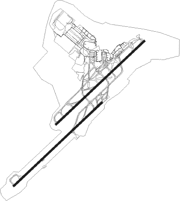
Taxiway locations
|
Parking locations
|
Nearby beacons
| code | identifier | dist | bearing | frequency |
|---|---|---|---|---|
| MCT | MANCHESTER VOR/DME | 0.4 | 76° | 113.55 |
| LPL | LIVERPOOL NDB | 16.1 | 268° | 349 |
| WHI | WHITEGATE NDB | 16.1 | 244° | 368 |
| POL | POLE HILL VOR/DME | 24.2 | 24° | 112.10 |
| HAW | HAWARDEN NDB | 27.3 | 256° | 340 |
| TNT | TRENT VOR/DME | 28.2 | 116° | 115.70 |
| WAL | WALLASEY VOR/DME | 30.8 | 273° | 114.10 |
| WTN | WARTON NDB | 31.5 | 305° | 337 |
| WTN | WARTON TACAN | 31.8 | 302° | 113.20 |
| SWB | SHAWBURY VOR/DME | 36.1 | 215° | 116.80 |
| BPL | BLACKPOOL NDB | 36.8 | 299° | 318 |
| TNL | TATENHILL NDB | 37.1 | 137° | 327 |
| LBA | LEEDS BRADFORD NDB | 37.8 | 51° | 402 |
| EMW | EAST MIDLANDS NDB | 43.2 | 123° | 393 |
| WBA | WOLVERHAMPTON NDB | 50.3 | 179° | 356 |
| WOL | DME | 50.3 | 179° | 108.60 |
| WPL | WELSHPOOL NDB | 53.8 | 231° | 323 |
| BHX | BIRMINGHAM NDB | 57.2 | 150° | 406 |
| WL | BARROW (WALNEY ISLAND) NDB | 58.2 | 308° | 385 |
| LEE | LEEMING TACAN | 62.3 | 38° | 112.60 |
| HON | HONILEY VOR/DME | 63.8 | 148° | 113.65 |
Departure and arrival routes
| Transition altitude | 5000ft |
| SID end points | distance | outbound heading | |
|---|---|---|---|
| RW05L | |||
| POL4S | 24mi | 24° | |
| DESI1S | 17mi | 66° | |
| LIST2S | 13mi | 160° | |
| MONT1S | 43mi | 243° | |
| ASMI1S | 15mi | 284° | |
| RW05R | |||
| POL1Z | 24mi | 24° | |
| DESI1Z | 17mi | 66° | |
| LIST2Z | 13mi | 160° | |
| MONT1Z | 43mi | 243° | |
| ASMI1Z | 15mi | 284° | |
| RW23L | |||
| POL1Y | 24mi | 24° | |
| LIST2Y | 13mi | 160° | |
| SANB1Y | 13mi | 195° | |
| MONT1Y | 43mi | 243° | |
| KUXE1Y | 16mi | 256° | |
| EKLA1Y | 21mi | 260° | |
| RW23R | |||
| POL5R | 24mi | 24° | |
| LIST2R | 13mi | 160° | |
| SANB1R | 13mi | 195° | |
| MONT1R | 43mi | 243° | |
| KUXE1R | 16mi | 256° | |
| EKLA1R | 21mi | 260° | |
| STAR starting points | distance | inbound heading | |
|---|---|---|---|
| ALL | |||
| MIRS1A | 36.2 | 72° | |
| DALE1G, ROSU1G | 85.3 | 266° | |
| DALE1F, ROSU1F | 82.8 | 272° | |
| DAYN2A | 28.2 | 296° | |
| DAYN1B | 56.9 | 297° | |
Instrument approach procedures
| runway | airway (heading) | route (dist, bearing) |
|---|---|---|
| RW23L | DOMIG (245°) | DOMIG 3500ft C23LI (5mi, 245°) 3500ft |
| RW23L | OSNAP (260°) | OSNAP 3500ft C23LI (5mi, 307°) 3500ft |
| RW23L | TINVA (225°) | TINVA 3500ft C23LI (5mi, 126°) 3500ft |
| RNAV | C23LI 3500ft C23LF (3mi, 244°) 3500ft EGCC (10mi, 245°) 277ft (3206mi, 178°) 660ft (turn) 3500ft |
Holding patterns
| STAR name | hold at | type | turn | heading* | altitude | leg | speed limit |
|---|---|---|---|---|---|---|---|
| DALE1F | DALEY | VHF | left | 328 (148)° | 7000ft - 14000ft | DME 4.7mi | ICAO rules |
| DALE1G | DALEY | VHF | left | 328 (148)° | 7000ft - 14000ft | DME 4.7mi | ICAO rules |
| DALE2A | DALEY | VHF | left | 328 (148)° | 7000ft - 14000ft | DME 4.7mi | ICAO rules |
| DALE2B | DALEY | VHF | left | 328 (148)° | 7000ft - 14000ft | DME 4.7mi | ICAO rules |
| DALE2E | DALEY | VHF | left | 328 (148)° | 7000ft - 14000ft | DME 4.7mi | ICAO rules |
| DALE4D | DALEY | VHF | left | 328 (148)° | 7000ft - 14000ft | DME 4.7mi | ICAO rules |
| DAYN1B | DAYNE | VHF | right | 132 (312)° | > 7000ft | DME 3.0mi | ICAO rules |
| DAYN2A | DAYNE | VHF | right | 132 (312)° | > 7000ft | DME 3.0mi | ICAO rules |
| MIRS1A | MIRSI | VHF | right | 241 (61)° | 6000ft - 14000ft | DME 5.0mi | ICAO rules |
| MIRS2C | MIRSI | VHF | right | 241 (61)° | 6000ft - 14000ft | DME 5.0mi | ICAO rules |
| MIRS2D | MIRSI | VHF | right | 241 (61)° | 6000ft - 14000ft | DME 5.0mi | ICAO rules |
| MIRS3B | MIRSI | VHF | right | 241 (61)° | 6000ft - 14000ft | DME 5.0mi | ICAO rules |
| ROSU1F | ROSUN | VHF | right | 352 (172)° | > 7000ft | 1.0min timed | ICAO rules |
| ROSU1G | ROSUN | VHF | right | 352 (172)° | > 7000ft | 1.0min timed | ICAO rules |
| ROSU2A | ROSUN | VHF | right | 352 (172)° | > 7000ft | 1.0min timed | ICAO rules |
| ROSU2B | ROSUN | VHF | right | 352 (172)° | > 7000ft | 1.0min timed | ICAO rules |
| ROSU2E | ROSUN | VHF | right | 352 (172)° | > 7000ft | 1.0min timed | ICAO rules |
| ROSU4D | ROSUN | VHF | right | 352 (172)° | > 7000ft | 1.0min timed | ICAO rules |
| *) magnetic outbound (inbound) holding course | |||||||
Disclaimer
The information on this website is not for real aviation. Use this data with the X-Plane flight simulator only! Data taken with kind consent from X-Plane 12 source code and data files. Content is subject to change without notice.