Amsterdam - Schiphol
Airport details
| Country | Netherlands |
| State | North Holland |
| Region | EH |
| Airspace | Amsterdam Ctr |
| Municipality | Haarlemmermeer |
| Elevation | -11ft (-3m) |
| Timezone | GMT +1 |
| Coordinates | 52.30806, 4.76417 |
| Magnetic var | |
| Type | land |
| Available since | X-Plane v10.40 |
| ICAO code | EHAM |
| IATA code | AMS |
| FAA code | n/a |
Communication
| Schiphol ATIS ARR | 132.980 |
| Schiphol ATIS Departure | 122.200 |
| Schiphol Clearance DEL | 121.975 |
| Schiphol Ground Control | 121.700 |
| Schiphol Ground Control | 121.800 |
| Schiphol Ground Control | 121.900 |
| Schiphol Tower | 119.225 |
| Schiphol Tower 18C/36C | 118.100 |
| Schiphol Tower 06/24 | 119.900 |
| Schiphol Approach | 119.050 |
| Schiphol Departure | 121.205 |
Approach frequencies
| ILS-cat-III | RW06 | 110.55 | 18.00mi |
| ILS-cat-III | RW36C | 108.75 | 18.00mi |
| ILS-cat-III | RW27 | 111.55 | 18.00mi |
| ILS-cat-III | RW18R | 110.1 | 18.00mi |
| ILS-cat-III | RW18C | 109.5 | 18.00mi |
| ILS-cat-III | RW36R | 111.95 | 18.00mi |
| ILS-cat-I | RW22 | 109.15 | 18.00mi |
| 3° GS | RW18C | 109.5 | 18.00mi |
| 3° GS | RW18R | 110.1 | 18.00mi |
| 3° GS | RW22 | 109.15 | 18.00mi |
| 3° GS | RW36C | 108.75 | 18.00mi |
| 3° GS | RW06 | 110.55 | 18.00mi |
| 3° GS | RW27 | 111.55 | 18.00mi |
| 3° GS | RW36R | 111.95 | 18.00mi |
Nearby Points of Interest:
Halte Aalsmeer Oost
-Bridge 514
-Bridge 518
-Politiebureautje Sloten
-Sint-Franciscus van Saleskerk
-Raadhuis van Aalsmeer
-Oude Kantongerecht Hoofddorp
-Hoofdvaartkerk (Hoofddorp)
-Bridge 530
-Halte Bovenkerk
-Hangbrugmaisonettes
-Sint-Annakerk
-Bridge 532
-Bridge 504
-Office buildings in Amstelveen
-Bridge 507
-Bridge 591
-Bridge 592
-Piet Römerbrug
-Verrijzenis van Onze Heer Jezus Christuskerk
-Telefooncentrale Amsterdam-Slotervaart
-National Aerospace Laboratory
-Sloterhof tower
-Bridge 705
-Sloterhof
Runway info
Runway 09 / 27  | ||
| length | 3444m (11299ft) | |
| bearing | 88° / 268° | |
| width | 45m (148ft) | |
| surface | asphalt | |
| displ threshold | 89m (292ft) / 0m (0ft) | |
| Runway 18L / 36R | ||
| length | 3396m (11142ft) | |
| bearing | 185° / 5° | |
| width | 45m (148ft) | |
| surface | asphalt | |
| displ threshold | 574m (1883ft) / 0m (0ft) | |
| Runway 18C / 36C | ||
| length | 3299m (10823ft) | |
| bearing | 185° / 5° | |
| width | 45m (148ft) | |
| surface | asphalt | |
| displ threshold | 0m (0ft) / 450m (1476ft) | |
| Runway 18R / 36L | ||
| length | 3798m (12461ft) | |
| bearing | 185° / 5° | |
| width | 60m (197ft) | |
| surface | asphalt | |
| displ threshold | 270m (886ft) / 0m (0ft) | |
| Runway 06 / 24 | ||
| length | 3436m (11273ft) | |
| bearing | 69° / 249° | |
| width | 45m (148ft) | |
| surface | asphalt | |
| displ threshold | 250m (820ft) / 0m (0ft) | |
| Runway 04 / 22 | ||
| length | 2021m (6631ft) | |
| bearing | 55° / 235° | |
| width | 45m (148ft) | |
| surface | asphalt | |
| blast zone | 0m (0ft) / 255m (837ft) | |
Airport layout - taxiway location A
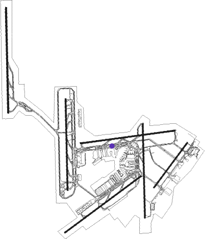
Taxiway locations
|
Parking locations
|
Nearby beacons
| code | identifier | dist | bearing | frequency |
|---|---|---|---|---|
| SPL | SCHIPHOL (AMSTERDAM) VOR/DME | 1.5 | 329° | 108.40 |
| AMS | DME | 2.6 | 293° | 113.95 |
| PAM | PAMPUS VOR/DME | 12.1 | 85° | 117.80 |
| SPY | DME | 14.3 | 21° | 113.30 |
| FRT | DME | 18.2 | 179° | 117.15 |
| RTM | ROTTERDAM VOR/DME | 22.6 | 220° | 110.40 |
| FRO | DME | 28.6 | 79° | 111.40 |
| HDR | HELDER DME | 35.9 | 0° | 115.55 |
| GZR | GILZE-RIJEN TACAN | 45 | 167° | 116.40 |
| VKL | VOLKEL TACAN | 52.4 | 125° | 108.30 |
| WDT | WOENSDRECHT TACAN | 53.9 | 206° | 115 |
| EHV | EINDHOVEN TACAN | 56.3 | 145° | 117.20 |
| LWD | LEEUWARDEN TACAN | 65.6 | 47° | 114.70 |
Departure and arrival routes
| Transition altitude | 3000ft |
| SID end points | distance | outbound heading | |
|---|---|---|---|
| RW04 | |||
| ANDI3F | 32mi | 50° | |
| ARNE3F | 50mi | 99° | |
| REND2F | 44mi | 107° | |
| LOPI2F | 26mi | 136° | |
| KUDA2F | 56mi | 204° | |
| VOLA2F | 50mi | 256° | |
| BERG2F | 30mi | 317° | |
| RW06 | |||
| ANDI3R, ANDI2T | 32mi | 50° | |
| ARNE3R, ARNE3T | 50mi | 99° | |
| REND2T, REND2R | 44mi | 107° | |
| LOPI2R | 26mi | 136° | |
| KUDA2T, KUDA2R | 56mi | 204° | |
| VOLA2R | 50mi | 256° | |
| BERG3R | 30mi | 317° | |
| RW09 | |||
| ANDI2N | 32mi | 50° | |
| ARNE3N | 50mi | 99° | |
| REND2N | 44mi | 107° | |
| LOPI2N | 26mi | 136° | |
| KUDA2N | 56mi | 204° | |
| VALK5M, IDRI2N | 50mi | 256° | |
| BERG3N | 30mi | 317° | |
| RW18C | |||
| TORG2X, BETU5Y | 32mi | 50° | |
| ELPA3X | 50mi | 99° | |
| EDUP3X | 44mi | 107° | |
| ROVE3X | 26mi | 136° | |
| LARA2X | 56mi | 204° | |
| DENA6X | 50mi | 256° | |
| WISP3X | 30mi | 317° | |
| RW18L | |||
| ANDI3E | 32mi | 50° | |
| ARNE4E | 50mi | 99° | |
| REND2E | 44mi | 107° | |
| LOPI4E | 26mi | 136° | |
| KUDA2E | 56mi | 204° | |
| VALK5E | 50mi | 256° | |
| BERG4E | 30mi | 317° | |
| RW22 | |||
| ANDI3G | 32mi | 50° | |
| ARNE4G | 50mi | 99° | |
| REND2G | 44mi | 107° | |
| LOPI2G | 26mi | 136° | |
| KUDA2G | 56mi | 204° | |
| VALK3G | 50mi | 256° | |
| BERG2G | 30mi | 317° | |
| RW24 | |||
| AND2SY, ANDI2S, SPY4KY, SPY4K | 32mi | 50° | |
| ARNE3S, ARN3SY | 50mi | 99° | |
| REN2SY, REND2S | 44mi | 107° | |
| LOP3SY, LOPI3S | 26mi | 136° | |
| KUD3SY, KUDA3S | 56mi | 204° | |
| VALK3S | 50mi | 256° | |
| BERG2S | 30mi | 317° | |
| RW27 | |||
| SPY2P | 32mi | 50° | |
| ARNE3P | 50mi | 99° | |
| REND2P | 44mi | 107° | |
| LOPI2P | 26mi | 136° | |
| KUDA2P | 56mi | 204° | |
| VOLA2P | 50mi | 256° | |
| BERG2P | 30mi | 317° | |
| RW36C | |||
| NOPS3W | 32mi | 50° | |
| NYKE5W | 50mi | 99° | |
| IVLU4W | 44mi | 107° | |
| OGIN4W | 26mi | 136° | |
| WOOD3W | 56mi | 204° | |
| RW36L | |||
| SPY4V | 32mi | 50° | |
| ARNE2Z, ARNE2V | 50mi | 99° | |
| REND2V, REND2Z | 44mi | 107° | |
| LOPI4V, LOPI2Z | 26mi | 136° | |
| KUDA2V, KUDA2Z | 56mi | 204° | |
| VOLA2Z, VOLA3V | 50mi | 256° | |
| BERG5V, BERG2Z | 30mi | 317° | |
| STAR starting points | distance | inbound heading | |
|---|---|---|---|
| ALL | |||
| HELE2A | 72.4 | 40° | |
| DENU3A | 76.3 | 46° | |
| REDF1A | 84.5 | 85° | |
| LAMS2A | 69.5 | 103° | |
| MOLI2A | 69.1 | 107° | |
| TOPA2A | 78.8 | 132° | |
| EEL1A, EEL1B | 86.1 | 246° | |
| NORK2B, NORK2A | 81.5 | 272° | |
| RKN2A, RKN2B | 74.3 | 275° | |
Instrument approach procedures
| runway | airway (heading) | route (dist, bearing) |
|---|---|---|
| RW04 | ARTIP (256°) | ARTIP SPL (32mi, 258°) AM201 (10mi, 174°) AM202 (4mi, 235°) AM203 (3mi, 298°) NELFE (2mi, 346°) 2000ft |
| RW04 | RIVER (58°) | RIVER SPL (34mi, 56°) SPL (turn) AM201 (10mi, 174°) AM202 (4mi, 235°) AM203 (3mi, 298°) NELFE (2mi, 346°) 2000ft |
| RW04 | SUGOL (105°) | SUGOL SPL (31mi, 104°) AM201 (10mi, 174°) AM202 (4mi, 235°) AM203 (3mi, 298°) NELFE (2mi, 346°) 2000ft |
| RNAV | NELFE 2000ft AM204 (3mi, 55°) 2000ft EHAM (6mi, 47°) 37ft AM205 (13mi, 59°) 2000ft | |
| RW06 | ARTIP (256°) | ARTIP SPL (32mi, 258°) AM101 (4mi, 278°) AM102 (10mi, 249°) AM103 (3mi, 134°) OSRON (2mi, 101°) 2000ft |
| RW06 | RIVER (58°) | RIVER SPL (34mi, 56°) AM101 (4mi, 278°) AM102 (10mi, 249°) AM103 (3mi, 134°) OSRON (2mi, 101°) 2000ft |
| RW06 | SUGOL (105°) | SUGOL SPL (31mi, 104°) SPL (turn) AM101 (4mi, 278°) AM102 (10mi, 249°) AM103 (3mi, 134°) OSRON (2mi, 101°) 2000ft |
| RNAV | OSRON 2000ft AM609 (3mi, 69°) 2000ft EHAM (8mi, 66°) 39ft AM104 (6mi, 72°) AM105 (5mi, 69°) 2000ft | |
| RW09 | ARTIP (256°) | ARTIP SPL (32mi, 258°) AM220 (6mi, 299°) AM221 (7mi, 268°) AM222 (3mi, 175°) IFTAZ (2mi, 123°) 2000ft |
| RW09 | RIVER (58°) | RIVER SPL (34mi, 56°) SPL (turn) AM220 (6mi, 299°) AM221 (7mi, 268°) AM222 (3mi, 175°) IFTAZ (2mi, 123°) 2000ft |
| RW09 | SUGOL (105°) | SUGOL SPL (31mi, 104°) SPL (turn) AM220 (6mi, 299°) AM221 (7mi, 268°) AM222 (3mi, 175°) IFTAZ (2mi, 123°) 2000ft |
| RNAV | IFTAZ 2000ft AM223 (3mi, 88°) 2000ft EHAM (7mi, 91°) 38ft AM224 (12mi, 87°) 2000ft | |
| RW18C | ALINA (179°) | ALINA SIDNI (5mi, 185°) 2000ft AM630 (3mi, 185°) 2000ft |
| RW18C | ART5B (5°) | ARTIP AM601 (28mi, 284°) AM602 (6mi, 270°) AM603 (6mi, 270°) NIRSI (6mi, 180°) AM607 (5mi, 90°) AM126 (3mi, 115°) 3400ft AM128 (3mi, 157°) AM130 (3mi, 171°) AM630 (2mi, 155°) 2000ft |
| RW18C | ARTIP (256°) | ARTIP SPL (32mi, 258°) SPL (turn) AM120 (6mi, 61°) AM121 (6mi, 6°) AM122 (3mi, 272°) SIDNI (2mi, 246°) 2000ft AM630 (3mi, 185°) 2000ft |
| RW18C | NIR2D (5°) | NIRSI AM607 (5mi, 90°) AM126 (3mi, 115°) 3400ft AM128 (3mi, 157°) AM130 (3mi, 171°) AM630 (2mi, 155°) 2000ft |
| RW18C | RIV5B (5°) | RIVER AM605 (9mi, 354°) NIRSI (34mi, 38°) AM607 (5mi, 90°) AM126 (3mi, 115°) 3400ft AM128 (3mi, 157°) AM130 (3mi, 171°) AM630 (2mi, 155°) 2000ft |
| RW18C | RIVER (58°) | RIVER SPL (34mi, 56°) AM120 (6mi, 61°) AM121 (6mi, 6°) AM122 (3mi, 272°) SIDNI (2mi, 246°) 2000ft AM630 (3mi, 185°) 2000ft |
| RW18C | SUG5B (5°) | SUGOL AM606 (17mi, 104°) NIRSI (11mi, 38°) AM607 (5mi, 90°) AM126 (3mi, 115°) 3400ft AM128 (3mi, 157°) AM130 (3mi, 171°) AM630 (2mi, 155°) 2000ft |
| RW18C | SUGOL (105°) | SUGOL SPL (31mi, 104°) AM120 (6mi, 61°) AM121 (6mi, 6°) AM122 (3mi, 272°) SIDNI (2mi, 246°) 2000ft AM630 (3mi, 185°) 2000ft |
| RNAV | AM630 2000ft EHAM (8mi, 173°) 38ft AM123 (12mi, 193°) 2000ft | |
| RW18R | ART5B (5°) | ARTIP AM601 (28mi, 284°) AM602 (6mi, 270°) AM603 (6mi, 270°) NIRSI (6mi, 180°) AM607 (5mi, 90°) AM133 (3mi, 119°) 3400ft AM135 (3mi, 160°) AM137 (turn) AM621 (1mi, 185°) 2000ft |
| RW18R | ARTIP (256°) | ARTIP SPL (32mi, 258°) AM240 (9mi, 304°) AM241 (6mi, 5°) AM242 (3mi, 92°) PEVOS (2mi, 120°) 2000ft AM621 (3mi, 185°) 2000ft |
| RW18R | DIBRU (173°) | DIBRU PEVOS (4mi, 185°) 2000ft AM621 (3mi, 185°) 2000ft |
| RW18R | NIR1R (5°) | NIRSI AM607 (5mi, 90°) AM133 (3mi, 119°) 3400ft AM135 (3mi, 160°) AM137 (turn) AM621 (1mi, 185°) 2000ft |
| RW18R | RIV5B (5°) | RIVER AM605 (9mi, 354°) NIRSI (34mi, 38°) AM607 (5mi, 90°) AM133 (3mi, 119°) 3400ft AM135 (3mi, 160°) AM137 (turn) AM621 (1mi, 185°) 2000ft |
| RW18R | RIVER (58°) | RIVER SPL (34mi, 56°) AM240 (9mi, 304°) AM241 (6mi, 5°) AM242 (3mi, 92°) PEVOS (2mi, 120°) 2000ft AM621 (3mi, 185°) 2000ft |
| RW18R | SUG5B (5°) | SUGOL AM606 (17mi, 104°) NIRSI (11mi, 38°) AM607 (5mi, 90°) AM133 (3mi, 119°) 3400ft AM135 (3mi, 160°) AM137 (turn) AM621 (1mi, 185°) 2000ft |
| RW18R | SUGOL (105°) | SUGOL SPL (31mi, 104°) SPL (turn) AM240 (9mi, 304°) AM241 (6mi, 5°) AM242 (3mi, 92°) PEVOS (2mi, 120°) 2000ft AM621 (3mi, 185°) 2000ft |
| RNAV | AM621 2000ft EHAM (9mi, 164°) 37ft EHAM (turn) 500ft AM624 (8mi, 282°) 2000ft AM624 (turn) 2000ft | |
| RW22 | AGOGO (217°) | AGOGO 3000ft AM671 (3mi, 114°) BLUSY (2mi, 174°) 2000ft |
| RW22 | AMEGA (253°) | AMEGA 3000ft AM672 (3mi, 289°) BLUSY (2mi, 268°) 2000ft |
| RW22 | ARTIP (256°) | ARTIP SPL (32mi, 258°) SPL (turn) PAM (13mi, 90°) AMEGA (5mi, 7°) 3000ft AM672 (3mi, 289°) BLUSY (2mi, 268°) 2000ft |
| RW22 | RIVER (58°) | RIVER SPL (34mi, 56°) PAM (13mi, 90°) AMEGA (5mi, 7°) 3000ft AM672 (3mi, 289°) BLUSY (2mi, 268°) 2000ft |
| RW22 | SUGOL (105°) | SUGOL SPL (31mi, 104°) PAM (13mi, 90°) AMEGA (5mi, 7°) 3000ft AM672 (3mi, 289°) BLUSY (2mi, 268°) 2000ft |
| RNAV | BLUSY 2000ft AM661 (4mi, 235°) 2000ft EHAM (7mi, 241°) 36ft (3151mi, 185°) 400ft AM675 (3141mi, 5°) 2000ft | |
| RW24 | ARTIP (256°) | ARTIP SPL (32mi, 258°) AM140 (4mi, 21°) AM141 (8mi, 69°) AM142 (3mi, 134°) ARWIN (2mi, 193°) 2000ft |
| RW24 | RIVER (58°) | RIVER SPL (34mi, 56°) AM140 (4mi, 21°) AM141 (8mi, 69°) AM142 (3mi, 134°) ARWIN (2mi, 193°) 2000ft |
| RW24 | SUGOL (105°) | SUGOL SPL (31mi, 104°) AM140 (4mi, 21°) AM141 (8mi, 69°) AM142 (3mi, 134°) ARWIN (2mi, 193°) 2000ft |
| RNAV | ARWIN 2000ft AM143 (3mi, 249°) 2000ft EHAM (6mi, 252°) 38ft AM144 (13mi, 247°) 2000ft | |
| RW27 | ARTIP (256°) | ARTIP SPL (32mi, 258°) SPL (turn) AM260 (6mi, 56°) AM261 (8mi, 88°) AM262 (3mi, 175°) TIDVO (2mi, 231°) 2000ft |
| RW27 | RIVER (58°) | RIVER SPL (34mi, 56°) AM260 (6mi, 56°) AM261 (8mi, 88°) AM262 (3mi, 175°) TIDVO (2mi, 231°) 2000ft |
| RW27 | SUGOL (105°) | SUGOL SPL (31mi, 104°) AM260 (6mi, 56°) AM261 (8mi, 88°) AM262 (3mi, 175°) TIDVO (2mi, 231°) 2000ft |
| RNAV | TIDVO 2000ft AM639 (3mi, 268°) 2000ft EHAM (7mi, 265°) 38ft AM263 (18mi, 269°) 3000ft | |
| RW36C | ARTIP (256°) | ARTIP SPL (32mi, 258°) AM280 (8mi, 241°) AM281 (7mi, 185°) AM282 (3mi, 92°) OLGAX (2mi, 65°) 2000ft |
| RW36C | BOVCO (10°) | BOVCO OLGAX (8mi, 5°) 2000ft |
| RW36C | RIVER (58°) | RIVER SPL (34mi, 56°) SPL (turn) AM280 (8mi, 241°) AM281 (7mi, 185°) AM282 (3mi, 92°) OLGAX (2mi, 65°) 2000ft |
| RW36C | SUGOL (105°) | SUGOL SPL (31mi, 104°) AM280 (8mi, 241°) AM281 (7mi, 185°) AM282 (3mi, 92°) OLGAX (2mi, 65°) 2000ft |
| RNAV | OLGAX 2000ft AM632 (3mi, 5°) 2000ft EHAM (6mi, 19°) 38ft AM283 (13mi, 358°) 2000ft | |
| RW36R | ARTIP (256°) | ARTIP SPL (32mi, 258°) AM160 (9mi, 125°) AM161 (7mi, 185°) AM162 (3mi, 272°) NEWCO (2mi, 300°) 2000ft |
| RW36R | KAROF (2°) | KAROF NEWCO (8mi, 5°) 2000ft |
| RW36R | RIVER (58°) | RIVER SPL (34mi, 56°) AM160 (9mi, 125°) AM161 (7mi, 185°) AM162 (3mi, 272°) NEWCO (2mi, 300°) 2000ft |
| RW36R | SUGOL (105°) | SUGOL SPL (31mi, 104°) AM160 (9mi, 125°) AM161 (7mi, 185°) AM162 (3mi, 272°) NEWCO (2mi, 300°) 2000ft |
| RNAV | NEWCO 2000ft AM636 (3mi, 5°) 2000ft EHAM (7mi, 358°) 39ft AM637 (4mi, 18°) 1500ft AM163 (8mi, 5°) 2000ft |
Holding patterns
| STAR name | hold at | type | turn | heading* | altitude | leg | speed limit |
|---|---|---|---|---|---|---|---|
| DENU3A | RIVER | VHF | right | 221 (41)° | > 7000ft | 1.0min timed | 250 |
| EEL1A | ARTIP | VHF | right | 72 (252)° | > 7000ft | 1.0min timed | 250 |
| EEL1B | ARTIP | VHF | right | 72 (252)° | > 7000ft | 1.0min timed | 250 |
| EEL1B | NARSO | VHF | left | 175 (355)° | > 20000ft | 1.0min timed | 220 |
| HELE2A | RIVER | VHF | right | 221 (41)° | > 7000ft | 1.0min timed | 250 |
| LAMS2A | SUGOL | VHF | right | 290 (110)° | > 7000ft | 1.0min timed | 250 |
| MOLI2A | SUGOL | VHF | right | 290 (110)° | > 7000ft | 1.0min timed | 250 |
| NORK2A | ARTIP | VHF | right | 72 (252)° | > 7000ft | 1.0min timed | 250 |
| NORK2B | ARTIP | VHF | right | 72 (252)° | > 7000ft | 1.0min timed | 250 |
| NORK2B | NARSO | VHF | left | 175 (355)° | > 20000ft | 1.0min timed | 220 |
| PESE3A | RIVER | VHF | right | 221 (41)° | > 7000ft | 1.0min timed | 250 |
| REDF1A | SUGOL | VHF | right | 290 (110)° | > 7000ft | 1.0min timed | 250 |
| RKN2A | ARTIP | VHF | right | 72 (252)° | > 7000ft | 1.0min timed | 250 |
| RKN2B | ARTIP | VHF | right | 72 (252)° | > 7000ft | 1.0min timed | 250 |
| RKN2B | NARSO | VHF | left | 175 (355)° | > 20000ft | 1.0min timed | 220 |
| TOPA2A | SUGOL | VHF | right | 290 (110)° | > 7000ft | 1.0min timed | 250 |
| *) magnetic outbound (inbound) holding course | |||||||
Disclaimer
The information on this website is not for real aviation. Use this data with the X-Plane flight simulator only! Data taken with kind consent from X-Plane 12 source code and data files. Content is subject to change without notice.