Tel Aviv - Tel Aviv Ben Gurion
Airport details
| Country | Israel |
| State | Center District |
| Region | LL |
| Airspace | Tel Aviv Ctr |
| Municipality | Ramla Subdistrict |
| Elevation | 132ft (40m) |
| Timezone | GMT +2 |
| Coordinates | 32.00945, 34.88556 |
| Magnetic var | |
| Type | land |
| Available since | X-Plane v10.40 |
| ICAO code | LLBG |
| IATA code | TLV |
| FAA code | n/a |
Communication
| Tel Aviv Ben Gurion ATIS | 132.500 |
| Tel Aviv Ben Gurion Clearance DEL | 119.350 |
| Tel Aviv Ben Gurion Ground Control EAST | 129.200 |
| Tel Aviv Ben Gurion Ground Control WEST | 118.050 |
| Tel Aviv Ben Gurion Tower | 118.300 |
| Tel Aviv Ben Gurion Approach | 120.500 |
| Tel Aviv Ben Gurion TMA | 119.500 |
| Tel Aviv Ben Gurion Departure | 120.500 |
Approach frequencies
| ILS-cat-I | RW08 | 110.9 | 18.00mi |
| ILS-cat-I | RW12 | 110.3 | 18.00mi |
| ILS-cat-I | RW21 | 109.7 | 18.00mi |
| ILS-cat-I | RW26 | 108.7 | 18.00mi |
| IGS | RW30 | 111.9 | 18.00mi |
| 3.2° GS | RW30 | 111.9 | 18.00mi |
| 3° GS | RW21 | 109.7 | 18.00mi |
| 3° GS | RW12 | 110.3 | 18.00mi |
| 3° GS | RW08 | 110.9 | 18.00mi |
| 3° GS | RW26 | 108.7 | 18.00mi |
Nearby Points of Interest:
Wilhelma
-Tel Litvinsky
-Swatitzky House
-The Security Road
-London Hotel
-Freimann House
-Rishon LeZion old water tower
-White mosque
-Bet HaTavshil
-Mikveh Israel
-Avraham Krinitzi Museum
-Borochov school
-Orda cinema
-Beit Shniderman
-Mamluk pharmacy in Borochov neighborhood
-Sheik Murad House
-Yarkon cinema (Rosh Ha'ayin)
-The Yemenite Jewry Heritage Center
-Shimon Levi house
-Moses Montefiore water tower
Runway info
Runway 12 / 30  | ||
| length | 3103m (10180ft) | |
| bearing | 117° / 297° | |
| width | 45m (148ft) | |
| surface | asphalt | |
| displ threshold | 0m (0ft) / 70m (230ft) | |
| blast zone | 255m (837ft) / 242m (794ft) | |
| Runway 08 / 26 | ||
| length | 4055m (13304ft) | |
| bearing | 81° / 261° | |
| width | 45m (148ft) | |
| surface | asphalt | |
| displ threshold | 404m (1325ft) / 599m (1965ft) | |
| blast zone | 255m (837ft) / 63m (207ft) | |
| Runway 03 / 21 | ||
| length | 2776m (9108ft) | |
| bearing | 33° / 213° | |
| width | 60m (197ft) | |
| surface | asphalt | |
| blast zone | 255m (837ft) / 255m (837ft) | |
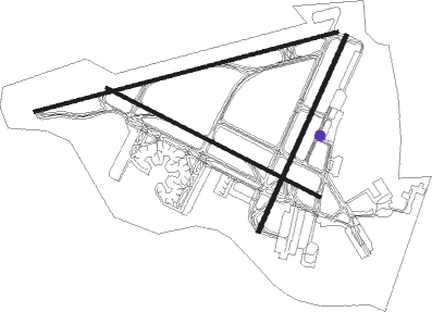
Airport layout - taxiway location V29
Taxiway locations
|
Parking locations
|
Nearby beacons
| code | identifier | dist | bearing | frequency |
|---|---|---|---|---|
| BGN | BEN GURION (TEL AVIV) VOR/DME | 0.5 | 290° | 113.50 |
| NAT | NATANIA VOR/DME | 19.9 | 14° | 112.40 |
| RMD | RAMAT DAVID NDB | 42.2 | 24° | 368 |
| BSA | BEER SHEBA VOR/DME | 44.2 | 193° | 114.30 |
| MZD | METZADA VOR/DME | 48.2 | 143° | 115 |
| MDB | MADABA NDB | 52.4 | 107° | 399 |
| ROP | ROSH-PINA VOR/DME | 68 | 35° | 115.30 |
Departure and arrival routes
| Transition altitude | 10000ft |
| Transition level | 11000ft |
| SID end points | distance | outbound heading | |
|---|---|---|---|
| RW03 | |||
| NAT1A | 20mi | 14° | |
| RW08 | |||
| NAT1B | 20mi | 14° | |
| SALA4B | 32mi | 97° | |
| TOMA4B | 35mi | 114° | |
| SUVA1B | 46mi | 280° | |
| DAFN1B | 46mi | 309° | |
| MERV2B | 50mi | 336° | |
| RW12 | |||
| NAT1D | 20mi | 14° | |
| SALA5C | 32mi | 97° | |
| TOMA5C | 35mi | 114° | |
| ORLE1C | 13mi | 274° | |
| SUVA2C | 46mi | 280° | |
| DAFN2C | 46mi | 309° | |
| PIDE2C, MERV3C | 50mi | 336° | |
| RW21 | |||
| SUVA1G | 46mi | 280° | |
| RW26 | |||
| SALA4E | 32mi | 97° | |
| TOMA4E, RIPU1E | 35mi | 114° | |
| ORLE1E | 13mi | 274° | |
| SUVA1E | 46mi | 280° | |
| DAFN1E | 46mi | 309° | |
| MERV2E, PIDE1E | 50mi | 336° | |
| RW30 | |||
| SALA4F | 32mi | 97° | |
| TOMA4F, RIPU1F | 35mi | 114° | |
| ORLE1F | 13mi | 274° | |
| SUVA1F | 46mi | 280° | |
| DAFN1F | 46mi | 309° | |
| PIDE1F, MERV2F | 50mi | 336° | |
| STAR starting points | distance | inbound heading | |
|---|---|---|---|
| RW08 | |||
| PURLA1 | 57.9 | 121° | |
| RW12 | |||
| GODED2 | 57.9 | 121° | |
| SALA2B | 32.4 | 277° | |
| AMIT1B | 37.2 | 304° | |
| RW21 | |||
| AMOS1A, AMOS1B | 57.9 | 121° | |
| SALA2A | 32.4 | 277° | |
| AMIT1A | 37.2 | 304° | |
| RW26 | |||
| AMOS1C, AMOS1D | 57.9 | 121° | |
| SALA2C | 32.4 | 277° | |
| AMIT1C | 37.2 | 304° | |
| RW30 | |||
| NINET1, AMOS1F, AMOS1E | 57.9 | 121° | |
| SALA3E | 32.4 | 277° | |
| AMIT1E | 37.2 | 304° | |
Instrument approach procedures
| runway | airway (heading) | route (dist, bearing) |
|---|---|---|
| RW08 | TAPUZ (94°) | TAPUZ 3000ft BG800 (7mi, 111°) 2400ft |
| RNAV | BG800 2400ft BG71W (4mi, 87°) 2400ft LLBG (8mi, 84°) 147ft BG810 (2mi, 70°) NOGAH (4mi, 222°) 3000ft BG065 (7mi, 284°) 5000ft BG065 (turn) | |
| RW12 | GODED (116°) | GODED 5000ft BG13W (4mi, 116°) 3000ft BG09W (4mi, 117°) 2500ft |
| RNAV | BG09W 2500ft BG07W (2mi, 117°) 2500ft LLBG (8mi, 116°) 153ft BG060 (3mi, 123°) BG065 (10mi, 276°) 3000ft BG065 (turn) 3000ft | |
| RW21-V | TADOV (161°) | TADOV VATAT (7mi, 105°) 3500ft NAMIM (4mi, 181°) 2500ft IBATI (5mi, 181°) 1300ft |
| RNAV | IBATI 1300ft LLBG (4mi, 218°) 184ft DER21 (turn) 1000ft (2758mi, 227°) 1000ft GEMDA (2764mi, 48°) 5000ft GEMDA (turn) 5000ft | |
| RW21-X | TADOV (161°) | TADOV VATAT (7mi, 105°) 3500ft NAMIM (4mi, 181°) 2500ft |
| RNAV | NAMIM 2500ft IBATI (5mi, 181°) 1300ft LLBG (4mi, 218°) 184ft DER21 (turn) 1000ft (2758mi, 227°) 1000ft GEMDA (2764mi, 48°) 5000ft GEMDA (turn) 5000ft | |
| RW21-Y | TADOV (161°) | TADOV VATAT (7mi, 105°) 3500ft BG218 (4mi, 180°) 2500ft |
| RNAV | BG218 2500ft BG217 (4mi, 180°) 1200ft BG216 (1mi, 197°) 1200ft LLBG (4mi, 219°) 184ft BG215 (2mi, 201°) GEMDA (8mi, 56°) 5000ft GEMDA (turn) 5000ft | |
| RW26 | RABIN (244°) | RABIN 3800ft GINTU (4mi, 136°) 3800ft LASRI (3mi, 235°) 3400ft |
| RNAV | LASRI 3400ft BG07E (5mi, 261°) 2500ft LLBG (8mi, 259°) 174ft (2758mi, 227°) 600ft BG070 (2753mi, 47°) 3000ft BG070 (turn) 3000ft | |
| RW30-R | HADAS (209°) | HADAS 6000ft MORIA (11mi, 167°) 3600ft ROMIE (4mi, 181°) 2400ft |
| RNAV | ROMIE 2400ft BG005 (3mi, 271°) 1800ft LLBG (6mi, 300°) 179ft DER30 (turn) 700ft (2758mi, 227°) 700ft BG050 (2752mi, 47°) 3000ft BG050 (turn) 3000ft | |
| RW30-V | LIMKO (115°) | LIMKO 5000ft REBDO (5mi, 149°) 4500ft GAVRI (9mi, 127°) 2500ft BG075 (3mi, 65°) 2100ft BG040 (3mi, 327°) 1700ft |
| RNAV | BG040 1700ft LLBG (5mi, 300°) 179ft DER30 (turn) 700ft (2758mi, 227°) 700ft BG050 (2752mi, 47°) 3000ft BG050 (turn) 3000ft | |
| RW30-W | HADAS (209°) | HADAS 6000ft MORIA (11mi, 167°) 3600ft ROMIE (4mi, 181°) 2400ft |
| RNAV | ROMIE 2400ft BG005 (3mi, 271°) 1800ft LLBG (6mi, 300°) 179ft DER30 (turn) 700ft (2758mi, 227°) 700ft BG050 (2752mi, 47°) 3000ft BG050 (turn) 3000ft | |
| RW30-X | LIMKO (115°) | LIMKO 5000ft REBDO (5mi, 149°) 4500ft GAVRI (9mi, 127°) 2500ft BG075 (3mi, 65°) 2100ft |
| RNAV | BG075 2100ft BG040 (3mi, 327°) 1700ft LLBG (5mi, 300°) 179ft DER30 (turn) 700ft (2758mi, 227°) 700ft BG050 (2752mi, 47°) 3000ft BG050 (turn) 3000ft |
Holding patterns
| STAR name | hold at | type | turn | heading* | altitude | leg | speed limit |
|---|---|---|---|---|---|---|---|
| AMIT1A | GATVU | VHF | left | 113 (293)° | 6000ft - 9000ft | 1.0min timed | 250 |
| AMIT1B | GATVU | VHF | left | 113 (293)° | 6000ft - 9000ft | 1.0min timed | 250 |
| AMIT1C | GATVU | VHF | left | 113 (293)° | 6000ft - 9000ft | 1.0min timed | 250 |
| AMIT1E | GATVU | VHF | left | 113 (293)° | 6000ft - 9000ft | 1.0min timed | 250 |
| AMOS1A | DIVLA | VHF | right | 288 (108)° | 5000ft - 8000ft | 1.0min timed | ICAO rules |
| AMOS1A | KONFO | VHF | right | 308 (128)° | 5000ft - 14000ft | 1.0min timed | 230 |
| AMOS1A | VETEK | VHF | right | 288 (108)° | 5000ft - 8000ft | 1.0min timed | ICAO rules |
| AMOS1A | ZUKKO | VHF | right | 308 (128)° | 5000ft - 14000ft | 1.0min timed | 230 |
| AMOS1B | DIVLA | VHF | right | 288 (108)° | 5000ft - 8000ft | 1.0min timed | ICAO rules |
| AMOS1B | KONFO | VHF | right | 308 (128)° | 5000ft - 14000ft | 1.0min timed | 230 |
| AMOS1B | VETEK | VHF | right | 288 (108)° | 5000ft - 8000ft | 1.0min timed | ICAO rules |
| AMOS1B | ZUKKO | VHF | right | 308 (128)° | 5000ft - 14000ft | 1.0min timed | 230 |
| AMOS1C | DIVLA | VHF | right | 288 (108)° | 5000ft - 8000ft | 1.0min timed | ICAO rules |
| AMOS1C | KONFO | VHF | right | 308 (128)° | 5000ft - 14000ft | 1.0min timed | 230 |
| AMOS1C | VETEK | VHF | right | 288 (108)° | 5000ft - 8000ft | 1.0min timed | ICAO rules |
| AMOS1C | ZUKKO | VHF | right | 308 (128)° | 5000ft - 14000ft | 1.0min timed | 230 |
| AMOS1D | DIVLA | VHF | right | 288 (108)° | 5000ft - 8000ft | 1.0min timed | ICAO rules |
| AMOS1D | KONFO | VHF | right | 308 (128)° | 5000ft - 14000ft | 1.0min timed | 230 |
| AMOS1D | VETEK | VHF | right | 288 (108)° | 5000ft - 8000ft | 1.0min timed | ICAO rules |
| AMOS1D | ZUKKO | VHF | right | 308 (128)° | 5000ft - 14000ft | 1.0min timed | 230 |
| AMOS1E | DIVLA | VHF | right | 288 (108)° | 5000ft - 8000ft | 1.0min timed | ICAO rules |
| AMOS1E | KONFO | VHF | right | 308 (128)° | 5000ft - 14000ft | 1.0min timed | 230 |
| AMOS1E | VETEK | VHF | right | 288 (108)° | 5000ft - 8000ft | 1.0min timed | ICAO rules |
| AMOS1E | ZUKKO | VHF | right | 308 (128)° | 5000ft - 14000ft | 1.0min timed | 230 |
| AMOS1F | DIVLA | VHF | right | 288 (108)° | 5000ft - 8000ft | 1.0min timed | ICAO rules |
| AMOS1F | KONFO | VHF | right | 308 (128)° | 5000ft - 14000ft | 1.0min timed | 230 |
| AMOS1F | VETEK | VHF | right | 288 (108)° | 5000ft - 8000ft | 1.0min timed | ICAO rules |
| AMOS1F | ZUKKO | VHF | right | 308 (128)° | 5000ft - 14000ft | 1.0min timed | 230 |
| GODED2 | DIRAN | VHF | left | 299 (119)° | 5000ft - 7000ft | 1.0min timed | 250 |
| GODED2 | GODED | VHF | left | 299 (119)° | 5000ft - 7000ft | 1.0min timed | 250 |
| GODED2 | KONFO | VHF | right | 308 (128)° | 5000ft - 14000ft | 1.0min timed | 230 |
| GODED2 | ZUKKO | VHF | right | 308 (128)° | 5000ft - 14000ft | 1.0min timed | 230 |
| NINET1 | DIRAN | VHF | left | 299 (119)° | 5000ft - 7000ft | 1.0min timed | 250 |
| NINET1 | GODED | VHF | left | 299 (119)° | 5000ft - 7000ft | 1.0min timed | 250 |
| NINET1 | KONFO | VHF | right | 308 (128)° | 5000ft - 14000ft | 1.0min timed | 230 |
| NINET1 | ZUKKO | VHF | right | 308 (128)° | 5000ft - 14000ft | 1.0min timed | 230 |
| PURLA1 | BAVLI | VHF | left | 269 (89)° | 5000ft - 5000ft | 1.0min timed | ICAO rules |
| PURLA1 | KONFO | VHF | right | 308 (128)° | 5000ft - 14000ft | 1.0min timed | 230 |
| PURLA1 | PURLA | VHF | left | 269 (89)° | 6000ft - 6000ft | 1.0min timed | ICAO rules |
| PURLA1 | TAPUZ | VHF | left | 269 (89)° | 3000ft - 3000ft | 1.0min timed | ICAO rules |
| PURLA1 | ZUKKO | VHF | right | 308 (128)° | 5000ft - 14000ft | 1.0min timed | 230 |
| SALA2A | GATVU | VHF | left | 113 (293)° | 6000ft - 9000ft | 1.0min timed | 250 |
| SALA2B | GATVU | VHF | left | 113 (293)° | 6000ft - 9000ft | 1.0min timed | 250 |
| SALA2C | GATVU | VHF | left | 113 (293)° | 6000ft - 9000ft | 1.0min timed | 250 |
| SALA3E | GATVU | VHF | left | 113 (293)° | 6000ft - 9000ft | 1.0min timed | 250 |
| *) magnetic outbound (inbound) holding course | |||||||
Disclaimer
The information on this website is not for real aviation. Use this data with the X-Plane flight simulator only! Data taken with kind consent from X-Plane 12 source code and data files. Content is subject to change without notice.