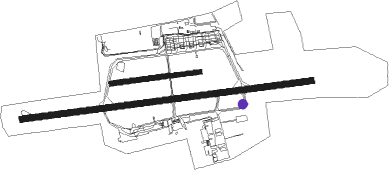
Linz - Linz Hoersching
Airport details
| Country | Austria |
| State | Upper Austria |
| Region | LO |
| Airspace | Vienna Ctr |
| Municipality | Hörsching |
| Elevation | 978ft (298m) |
| Timezone | GMT +1 |
| Coordinates | 48.23094, 14.19756 |
| Magnetic var | |
| Type | land |
| Available since | X-Plane v10.40 |
| ICAO code | LOWL |
| IATA code | LNZ |
| FAA code | n/a |
Communication
| Linz Hoersching ATIS | 128.125 |
| Linz Hoersching Tower | 118.800 |
| Linz Hoersching RADAR | 129.625 |
Approach frequencies
| ILS-cat-III | RW26 | 109.3 | 18.00mi |
| ILS-cat-I | RW08 | 110.55 | 18.00mi |
| 3° GS | RW26 | 109.3 | 18.00mi |
| 3° GS | RW08 | 110.55 | 18.00mi |
Runway info
Nearby beacons
| code | identifier | dist | bearing | frequency |
|---|---|---|---|---|
| LNZ | LINZ VOR/DME | 3.7 | 269° | 116.60 |
| LNZ | LINZ NDB | 4.9 | 87° | 327 |
| FRE | DME | 12.3 | 341° | 113.50 |
Departure and arrival routes
| Transition altitude | 4000ft |
| SID end points | distance | outbound heading | |
|---|---|---|---|
| RW08 | |||
| PERO1E | 11mi | 88° | |
| LIMR1E | 22mi | 142° | |
| LIDS1E | 12mi | 268° | |
| PETE1E | 11mi | 353° | |
| RW26 | |||
| PERO1W | 11mi | 88° | |
| LIMR1W | 22mi | 142° | |
| LIDS1W | 12mi | 268° | |
| PETE1W | 11mi | 353° | |
| STAR starting points | distance | inbound heading | |
|---|---|---|---|
| ALL | |||
| NUBR1K | 31.1 | 28° | |
| NEMA1K | 33.7 | 66° | |
| SBG1K | 54.0 | 80° | |
| AKIM1K | 37.0 | 102° | |
| DEXI1K | 37.3 | 137° | |
| ADLE1K | 20.6 | 197° | |
| STO2K | 73.5 | 264° | |
| SITN1K | 27.6 | 286° | |
| LIMR1K | 21.6 | 322° | |
Instrument approach procedures
| runway | airway (heading) | route (dist, bearing) |
|---|---|---|
| RW08 | ARA1C (16°) | ARASA 8000ft WL812 (6mi, 356°) 5000ft WL802 (12mi, 268°) 4000ft WL807 (5mi, 268°) 4000ft WL808 (5mi, 355°) 4000ft LIDSI (5mi, 88°) 4000ft |
| RW08 | PET1C (16°) | PETEN 6000ft WL811 (6mi, 176°) 5000ft WL801 (12mi, 268°) 4000ft WL806 (5mi, 268°) 4000ft WL808 (5mi, 175°) 4000ft LIDSI (5mi, 88°) 4000ft |
| RW08 | WL801 (104°) | WL801 4000ft LIDSI (5mi, 175°) 4000ft |
| RW08 | WL802 (73°) | WL802 4000ft LIDSI (5mi, 355°) 4000ft |
| RNAV | LIDSI 4000ft WL803 (5mi, 88°) 3000ft LOWL (7mi, 89°) 1031ft WL623 (5mi, 87°) LIDSI (17mi, 268°) 4000ft LIDSI (turn) | |
| RW26 | ARA1D (16°) | ARASA 8000ft WL812 (6mi, 356°) 5000ft WL822 (12mi, 88°) 4000ft WL827 (5mi, 88°) 4000ft WL828 (5mi, 356°) 4000ft PEROL (5mi, 268°) 4000ft |
| RW26 | PET1D (16°) | PETEN 6000ft WL811 (6mi, 176°) 5000ft WL821 (12mi, 88°) 5000ft WL826 (5mi, 88°) 4000ft WL828 (5mi, 176°) 4000ft PEROL (5mi, 268°) 4000ft |
| RW26 | WL821 (251°) | WL821 5000ft PEROL (5mi, 176°) 4000ft |
| RW26 | WL822 (284°) | WL822 4000ft PEROL (5mi, 356°) 4000ft |
| RNAV | PEROL 4000ft WL823 (5mi, 268°) 3000ft LOWL (7mi, 267°) 1016ft WL824 (5mi, 269°) PEROL (16mi, 88°) 4000ft PEROL (turn) |
Holding patterns
| STAR name | hold at | type | turn | heading* | altitude | leg | speed limit |
|---|---|---|---|---|---|---|---|
| ADLE1K | PETEN | VHF | right | 353 (173)° | > 6000ft | 1.0min timed | ICAO rules |
| AKIM1K | PETEN | VHF | right | 353 (173)° | > 6000ft | 1.0min timed | ICAO rules |
| DEXI1K | PETEN | VHF | right | 353 (173)° | > 6000ft | 1.0min timed | ICAO rules |
| LIMR1K | ARASA | VHF | right | 173 (353)° | > 8000ft | 1.0min timed | ICAO rules |
| LNZ1K | PETEN | VHF | right | 353 (173)° | > 6000ft | 1.0min timed | ICAO rules |
| NEMA1K | ARASA | VHF | right | 173 (353)° | > 8000ft | 1.0min timed | ICAO rules |
| NUBR1K | ARASA | VHF | right | 173 (353)° | > 8000ft | 1.0min timed | ICAO rules |
| SBG1K | ARASA | VHF | right | 173 (353)° | > 8000ft | 1.0min timed | ICAO rules |
| SITN1K | ARASA | VHF | right | 173 (353)° | > 8000ft | 1.0min timed | ICAO rules |
| STO2K | PETEN | VHF | right | 353 (173)° | > 6000ft | 1.0min timed | ICAO rules |
| *) magnetic outbound (inbound) holding course | |||||||
Disclaimer
The information on this website is not for real aviation. Use this data with the X-Plane flight simulator only! Data taken with kind consent from X-Plane 12 source code and data files. Content is subject to change without notice.

