Nha Trang - Cam Ranh
Airport details
| Country | Vietnam |
| State | Khánh Hòa Province |
| Region | VV |
| Airspace | Ho Chi Minh Ctr |
| Municipality | Cam Ranh city |
| Elevation | 40ft (12m) |
| Timezone | GMT +7 |
| Coordinates | 11.99546, 109.21841 |
| Magnetic var | |
| Type | land |
| Available since | X-Plane v10.40 |
| ICAO code | VVCR |
| IATA code | CXR |
| FAA code | n/a |
Communication
| Cam Ranh Tower | 118.200 |
| Cam Ranh Approach | 127.900 |
Approach frequencies
| ILS-cat-I | RW20L | 110.3 | 18.00mi |
| ILS-cat-I | RW02L | 110.7 | 18.00mi |
| ILS-cat-I | RW02R | 111.9 | 18.00mi |
| 3.5° GS | RW02L | 110.7 | 18.00mi |
| 3.5° GS | RW02R | 111.9 | 18.00mi |
| 3° GS | RW20L | 110.3 | 18.00mi |
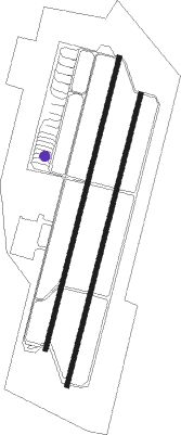
Runway info
Runway 02L / 20R  | ||
| length | 3063m (10049ft) | |
| bearing | 19° / 199° | |
| width | 46m (150ft) | |
| surface | concrete | |
| blast zone | 255m (837ft) / 255m (837ft) | |
| Runway 02R / 20L | ||
| length | 3057m (10030ft) | |
| bearing | 19° / 199° | |
| width | 45m (148ft) | |
| surface | concrete | |
Nearby beacons
| code | identifier | dist | bearing | frequency |
|---|---|---|---|---|
| CRA | CAM RANH VOR/DME | 0.1 | 123° | 116.50 |
| CR | CAM RANH NDB | 0.3 | 337° | 414 |
| LKH | LIEN KHUONG VOR/DME | 52.7 | 254° | 112.30 |
| HYD | DALAT NDB | 53.8 | 255° | 312 |
| DL | DALAT NDB | 57.9 | 255° | 330 |
Departure and arrival routes
| Transition altitude | 9030ft |
| Transition level | 10000ft |
| SID end points | distance | outbound heading | |
|---|---|---|---|
| RW02 (ALL) | |||
| NITO1A | 95mi | 62° | |
| PTH1A | 16mi | 227° | |
| DALA1A | 16mi | 255° | |
| KARA1B, KARA1A | 39mi | 355° | |
| RW02L | |||
| FURA1A, NITO1C | 95mi | 62° | |
| PTH1C | 16mi | 227° | |
| DALA1C | 16mi | 255° | |
| PANL1A | 41mi | 302° | |
| NIHO1A | 22mi | 355° | |
| KARA1E, KARA1D | 39mi | 355° | |
| RW02R | |||
| FURA1A | 95mi | 62° | |
| PANL1A | 41mi | 302° | |
| NIHO1A | 22mi | 355° | |
| RW20 (ALL) | |||
| NITO1B | 95mi | 62° | |
| PTH1B | 16mi | 227° | |
| DALA1B | 16mi | 255° | |
| KARA1C | 39mi | 355° | |
| RW20L | |||
| KOPO1A | 95mi | 62° | |
| ANKI1B | 22mi | 227° | |
| BANK1B | 22mi | 254° | |
| SOTE1B | 22mi | 302° | |
| NIHO1B | 22mi | 355° | |
| RW20R | |||
| NITO1D, KOPO1A | 95mi | 62° | |
| ANKI1B | 22mi | 227° | |
| PTH1D | 16mi | 227° | |
| BANK1B | 22mi | 254° | |
| DALA1D | 16mi | 255° | |
| SOTE1B | 22mi | 302° | |
| NIHO1B | 22mi | 355° | |
| KARA1F | 39mi | 355° | |
| STAR starting points | distance | inbound heading | |
|---|---|---|---|
| ALL | |||
| SUID1A | 16.2 | 47° | |
| PANC1A | 16.1 | 75° | |
| NHAT1A | 13.9 | 176° | |
| PHUS1A | 16.2 | 242° | |
| RW02 (ALL) | |||
| ANKI1A | 21.6 | 47° | |
| BANK1A | 21.5 | 74° | |
| COTU2A | 21.7 | 197° | |
| HUNT2A | 21.6 | 242° | |
| RW02L | |||
| NHAT1C | 13.9 | 176° | |
| RW20 (ALL) | |||
| BANK1C | 21.5 | 74° | |
| PANL1B | 21.6 | 150° | |
| COTU3B | 21.7 | 197° | |
| HUNT2B | 21.6 | 242° | |
| RW20R | |||
| SUID1B | 16.2 | 47° | |
| PANC1B | 16.1 | 75° | |
| NHAT1B | 13.9 | 176° | |
| PHUS1B | 16.2 | 242° | |
Instrument approach procedures
| runway | airway (heading) | route (dist, bearing) |
|---|---|---|
| RW02LY | CR220 (295°) | CR220 4000ft CR021 (16mi, 258°) CR022 (8mi, 296°) 2600ft |
| RNAV | CR022 2600ft CR023 (3mi, 19°) 2140ft MR02L (4mi, 19°) 583ft CR218 (5mi, 19°) CR219 (12mi, 83°) 4000ft CR220 (15mi, 153°) 4000ft CR220 (turn) 4000ft | |
| RW02LZ | CR021 (342°) | CR021 5000ft CR022 (8mi, 296°) 2600ft |
| RNAV | CR022 2600ft CR023 (3mi, 19°) 2140ft MR02L (4mi, 19°) 583ft CR218 (5mi, 19°) CR219 (12mi, 83°) 4000ft CR220 (15mi, 153°) 4000ft CR220 (turn) 4000ft | |
| RW02RY | CR220 (295°) | CR220 4000ft CR021 (16mi, 258°) CR822 (8mi, 296°) 2610ft |
| RNAV | CR822 2610ft CR823 (3mi, 19°) 2140ft VVCR (6mi, 18°) 69ft CR818 (4mi, 21°) CR219 (11mi, 89°) 4000ft CR220 (15mi, 153°) 4000ft CR220 (turn) 4000ft | |
| RW02RZ | CR021 (342°) | CR021 5000ft CR822 (8mi, 296°) 2610ft |
| RNAV | CR822 2610ft CR823 (3mi, 19°) 2140ft VVCR (6mi, 18°) 69ft CR818 (4mi, 21°) CR219 (11mi, 89°) 4000ft CR220 (15mi, 153°) 4000ft CR220 (turn) 4000ft | |
| RW20LY | CR223 (299°) | CR223 4000ft CR201 (21mi, 336°) CR293 (7mi, 288°) 3120ft |
| RNAV | CR293 3120ft CR294 (4mi, 199°) 2140ft VVCR (7mi, 200°) 84ft CR295 (4mi, 197°) 2000ft CR222 (15mi, 133°) CR223 (10mi, 68°) 4000ft CR223 (turn) 4000ft | |
| RW20LZ | CR201 (230°) | CR201 5000ft CR293 (7mi, 288°) 3120ft |
| RW20LZ | CR202 (199°) | CR202 4000ft CR293 (4mi, 197°) 3120ft |
| RW20LZ | CR209 (159°) | CR209 6000ft CR293 (10mi, 108°) 3120ft |
| RNAV | CR293 3120ft CR294 (4mi, 199°) 2140ft VVCR (7mi, 200°) 84ft CR295 (4mi, 197°) 2000ft CR222 (15mi, 133°) CR223 (10mi, 68°) 4000ft CR223 (turn) 4000ft | |
| RW20RY | CR223 (299°) | CR223 4000ft CR201 (21mi, 336°) CR203 (7mi, 289°) 3100ft |
| RNAV | CR203 3100ft CR204 (4mi, 199°) 2140ft VVCR (7mi, 199°) 96ft CR205 (4mi, 199°) 2000ft CR222 (15mi, 133°) CR223 (10mi, 68°) 4000ft CR223 (turn) 4000ft | |
| RW20RZ | CR201 (230°) | CR201 5000ft CR203 (7mi, 289°) 3100ft |
| RW20RZ | CR202 (199°) | CR202 4000ft CR203 (4mi, 199°) 3100ft |
| RW20RZ | CR209 (159°) | CR209 6000ft CR203 (10mi, 108°) 3100ft |
| RNAV | CR203 3100ft CR204 (4mi, 199°) 2140ft VVCR (7mi, 199°) 96ft CR205 (4mi, 199°) 2000ft CR222 (15mi, 133°) CR223 (10mi, 68°) 4000ft CR223 (turn) 4000ft |
Holding patterns
| STAR name | hold at | type | turn | heading* | altitude | leg | speed limit |
|---|---|---|---|---|---|---|---|
| ANKI1A | ANKIN | VHF | right | 232 (52)° | 9000ft - 14000ft | 1.0min timed | 230 |
| ANKI1A | CR021 | VHF | left | 117 (297)° | 5000ft - 14000ft | 1.0min timed | 230 |
| BANK1A | BANKE | VHF | left | 261 (81)° | 11000ft - 14000ft | 1.0min timed | 230 |
| BANK1A | CR021 | VHF | left | 117 (297)° | 5000ft - 14000ft | 1.0min timed | 230 |
| BANK1C | BANKE | VHF | left | 261 (81)° | 11000ft - 14000ft | 1.0min timed | 230 |
| BANK1C | CR209 | VHF | left | 289 (109)° | 6000ft - 14000ft | 1.0min timed | 230 |
| COTU2A | CR021 | VHF | left | 117 (297)° | 5000ft - 14000ft | 1.0min timed | 230 |
| COTU2A | SIMME | VHF | left | 355 (175)° | 12000ft - 14000ft | 1.0min timed | 230 |
| COTU3B | CR202 | VHF | left | 19 (199)° | 4000ft - 14000ft | 1.0min timed | 230 |
| COTU3B | SIMME | VHF | left | 355 (175)° | 12000ft - 14000ft | 1.0min timed | 230 |
| HUNT2A | CR021 | VHF | left | 117 (297)° | 5000ft - 14000ft | 1.0min timed | 230 |
| HUNT2A | LIGUN | VHF | left | 63 (243)° | 14000ft - 14000ft | 1.0min timed | 230 |
| HUNT2B | CR201 | VHF | right | 110 (290)° | 5000ft - 14000ft | 1.0min timed | 230 |
| HUNT2B | LIGUN | VHF | left | 63 (243)° | 14000ft - 14000ft | 1.0min timed | 230 |
| PANL1B | CHUTU | VHF | left | 277 (97)° | 11000ft - 14000ft | 1.0min timed | 230 |
| PANL1B | CR209 | VHF | left | 289 (109)° | 6000ft - 14000ft | 1.0min timed | 230 |
| SOTE1A | BIDAM | VHF | left | 303 (123)° | 8000ft - 14000ft | 1.0min timed | 230 |
| SOTE1A | CR021 | VHF | left | 117 (297)° | 5000ft - 14000ft | 1.0min timed | 230 |
| *) magnetic outbound (inbound) holding course | |||||||
Disclaimer
The information on this website is not for real aviation. Use this data with the X-Plane flight simulator only! Data taken with kind consent from X-Plane 12 source code and data files. Content is subject to change without notice.